- Block Island Southeast Light
Infobox_nrhp | name =Block Island South East Light
nrhp_type = nhl
caption =
location= South East Light Road,New Shoreham, Rhode Island
locmapin = Rhode Island
area =
built =1874
architect= US Light House Board; Tynan, T.H.
architecture= Gothic
designated=September 24 ,1997 cite web|url=http://tps.cr.nps.gov/nhl/detail.cfm?ResourceId=-1849338372&ResourceType=Structure
title=Block Island South East Light |accessdate=2008-05-04|work=National Historic Landmark summary listing|publisher=National Park Service]
added =September 25 ,1997 cite web|url=http://www.nr.nps.gov/|title=National Register Information System|date=2007-01-23|work=National Register of Historic Places|publisher=National Park Service]
governing_body = Private
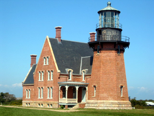
refnum=97001264 90001131cite web|url=http://www.nr.nps.gov/|title=National Register Information System|date=2007-01-23|work=National Register of Historic Places|publisher=National Park Service]Block Island Southeast Light is a
lighthouse located on the southeastern shore ofBlock Island ,Rhode Island . The lighthouse signals sea traffic coming from theAtlantic Ocean into the waters of Block Island andLong Island Sound , and remains an active navigational aid to sea vessels. [http://www.blockislandinfo.com/whattodo/lighthouses.php What To Do - Lighthouses - Block Island Tourism Council] ; "Block Island Tourism Council"; retrieved onOctober 22 ,2007 ] It was designated a U.S.National Historic Landmark in 1997.cite web|url=http://www.nps.gov/history/maritime/nhl/blockisl.htm
title=Block Island South East Lighthouse National Historic Landmark Study |author=Andrea E. Reynolds |accessdate=2007-10-22|work= |publisher=National Park Service]Construction
Construction on the lighthouse began in 1874, after Congress and President
Ulysses S. Grant approved $75,000 in funding for the project 2 years prior. Construction was completed in 1875 by T.H. Tynan ofStaten Island . The original station was built in theVictorian Gothic style with a convert|67|ft|m|0 tall octagonal light tower. Connected to the tower is a 2- 1/2 story keepers residence.Lens
The station includes a first-order
Fresnel lens that has afocal plane convert|52.5|ft|m|0 above ground (convert|204|ft|m|0 above sea level). The tower originally contained a white light until 1929, when it was replaced with a green light with a range of convert|22|mi|km|0. This light was convert|12|ft|m|0 high by convert|6|ft|m|0 wide and stayed in service until 1990, when it was replaced by theUnited States Coast Guard over environmental concerns stemming from its use of mercury. In 1994 the Coast Guard agreed to relight the lighthouse and relocated the lens in theCape Lookout Lighthouse inNorth Carolina to the Southeast Lighthouse. The lens is flashed every five seconds.Bluff Erosion
The Mohegan Bluffs have suffered continuous
erosion , and the edge of the cliff gradually approached the established site of Block Island Southeast Light. The lighthouse was originally placed convert|300|ft|m|0 from the edge of the Mohegan Bluffs, but in 1993 was moved back convert|360|ft|m|0, which had eroded roughly convert|250|ft|m|0.Museum
The lighthouse has a museum displaying the original Fresnel lens. [http://www.uscg.mil/history/WEBLIGHTHOUSES/LHRI.html Rhode Island Light Stations] ; "United States Coast Guard"; retrieved on
October 22 ,2007 ] The museum is open during the summer season [http://seagrant.gso.uri.edu/daytrip/block_island.html Daytripper's Guide: Block Island] ; "University of Rhode Island Sea Grant"; retrieved onOctober 22 ,2007 ] , provides tours of the light tower, and has a small gift shop.References
External links
* [http://hdl.loc.gov/loc.pnp/hhh.ri0392 Block Island Southeast Light, Spring Street & Mohegan Trail at Mohegan Bluffs, New Shoreham, Washington County, RI: 53 photos, 12 drawings, 55 data pages] , at
Historic American Building Survey
Wikimedia Foundation. 2010.