- Drake, New South Wales
-
Drake
New South Wales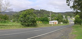
Bruxner Highway, Drake
 Drake
DrakePopulation: 409 (2006 census)[1] Established: 1860s Postcode: 2470 Coordinates: 28°56′S 152°24′E / 28.933°S 152.4°ECoordinates: 28°56′S 152°24′E / 28.933°S 152.4°E Elevation: 500 m (1,640 ft) Location: - 800 km (497 mi) N of Sydney
- 44 km (27 mi) E of Tenterfield
LGA: Tenterfield Shire County: Drake County State District: Northern Tablelands, Lismore Federal Division: New England Drake is a parish and small rural community on the Bruxner Highway approximately 44 km east of Tenterfield, New South Wales and about 800 km north of Sydney, New South Wales. It is in the Tenterfield Shire Local Government Area, which is part of the New England region. At the 2006 census, Drake had a population of 409 people.[1]
History
In 1858 gold was discovered near Newman’s Pinch on the western side of Fairfield (now Drake) and Timbarra[2] and quite a few years later copper was also mined in the vicinity.
A Timbarra Post Office opened on 1 November 1858, was renamed Drake in 1867 and closed in 1871. The later Drake office opened on 1 April 1879 and closed in 1985[3].
During the 1860s the first sale of Drake allotments took place with 16 of the 40 lots being sold. The Public School opened in November 1887.
The Australian Antimony Co. began mining here in 1872, with Drake as their community centre.[4] Between 1872 and 1890 Drake was a thriving mining and timber town with 12 hotels, a town band, and many private dwellings, plus a number of businesses including a blacksmith, post office and stores. A weekly coach run was established to run from Tenterfield to Casino in 1885.[4] The town also served as a stopping point for bullock teams, drovers and settlers passing between inland and coastal regions.
The original Police Station and house is near the cemetery, but is privately owned. There is a new Rural Transaction & Resource Centre (next to the park and toilet facilities). St Peter the Apostle Anglican Church (former) has been placed on the Register of the National Estate.
There are about thirty dwellings in Drake village which has a population of 131,[5] and the surrounding area has about 409 people.[5] The community is agricultural, timber and tourist based providing hiking, fishing and fossicking etc.
References
- ^ a b Australian Bureau of Statistics (25 October 2007). "Drake (State Suburb)". 2006 Census QuickStats. http://www.censusdata.abs.gov.au/ABSNavigation/prenav/LocationSearch?collection=Census&period=2006&areacode=SSC16999&producttype=QuickStats&breadcrumb=PL&action=401. Retrieved 21 July 2009.
- ^ GNB Retrieved on 8 October 2008
- ^ Premier Postal History. "Post Office List". Premier Postal Auctions. https://www.premierpostal.com/cgi-bin/wsProd.sh/Viewpocdwrapper.p?SortBy=NSW&country=. Retrieved 2011-05-26.
- ^ a b Donald, J. Kay, Exploring the North Coast and New England, Kangaroo Press, Kenthurst, 1987
- ^ a b Australian Bureau of Statistics (25 October 2007). "Drake village". 2006 Census QuickStats. http://www.censusdata.abs.gov.au/ABSNavigation/prenav/LocationSearch?collection=Census&period=2006&areacode=SSC17001&producttype=QuickStats&breadcrumb=PL&action=401. Retrieved 2008-10-6.
- Call of the Highlands (The Tenterfield Story) 1828-1988, Ken Halliday, Southern Cross Printery, Toowoomba, c. 1988
External links
Categories:- Towns in New South Wales
- Mining towns in New South Wales
- Towns in New England, New South Wales


Wikimedia Foundation. 2010.