- Chincoteague, Virginia
-
Chincoteague, Virginia — Town — Fishing boats along the waterfront in Chincoteague Location in Virginia
Coordinates: 37°56′5″N 75°22′4″W / 37.93472°N 75.36778°WCoordinates: 37°56′5″N 75°22′4″W / 37.93472°N 75.36778°W Country United States State Virginia County Accomack Incorporated 1908 Government – Mayor John H. Tarr Area – Total 37.1 sq mi (96.0 km2) – Land 9.6 sq mi (24.9 km2) – Water 27.4 sq mi (71.1 km2) Elevation 3 ft (1 m) Population (2000) – Total 4,317 – Density 448.2/sq mi (173.1/km2) Time zone Eastern (EST) (UTC-5) – Summer (DST) EDT (UTC-4) ZIP code 23336 Area code(s) 757 FIPS code 51-16512[1] GNIS feature ID 1492764[2] Website http://www.chincoteague-va.gov/ Chincoteague (pronounced /ˌʃɪŋkəˈtiːɡ/ or /ˈʃɪŋkətiːɡ/) is a town on Chincoteague Island in Accomack County, Virginia, United States. The population was 4,317 at the 2000 census. The town is perhaps best known for the Chincoteague Ponies, although these are not actually on the island of Chincoteague but on nearby Assateague Island. These ponies and the annual Pony Penning Day are the subject of Marguerite Henry's 1947 children's book Misty of Chincoteague. This was made into the 1961 family film Misty, which was filmed on location.
Contents
Geography
Chincoteague is located at 37°56′5″N 75°22′4″W / 37.93472°N 75.36778°W (37.934673, -75.367805).[3] According to the United States Census Bureau, the town has a total area of 37.1 square miles (96.0 km²), of which, 9.6 square miles (24.9 km²) of it is land and 27.4 square miles (71.1 km²) of it (74.02%) is water.
History
1650 marks the first land grant issued on Chincoteague Island for 1,500 acres (6.1 km2). Daniel Jenifer became the first English landowner.[4] In 1671, settlers came to the Island and by 1672, there were large farms by Bishops, Bowdens, Jesters and Tarrs. By 1838, there were 36 houses on the island and in 1861, the island voted 132-2 not to secede from the Union and against slavery. The town saw minor action in the war via the Battle of Cockle Creek fought in the bay in 1861
The Native American name for the island is "Gingoteague"[4] and the name of the town "Chincoteague" first appeared in the Decisions of the United States Board on Geographical Names in 1943.[5]
In 1962, a major nor'easter winter storm, the Ash Wednesday Storm, struck the coast. The town was completely underwater, and went for days without electricity. The storm destroyed almost all structures on Assateague Island, where development was just beginning. Following this, most of the island was preserved from development as Assateague Island National Seashore in 1965.
Chincoteague Ponies
Main article: Chincoteague ponyLegend has it that the feral ponies on Assateague are descendants of survivors a Spanish galleon that sank on its way to Spain during a storm in 1750 off the east coast, but the likelihood is that they are actually descended from domesticated stock, brought to the island by Eastern Shore farmers in the 17th century to avoid fencing requirements and taxation.
In the Pony Penning, which has been held annually since 1925, horses swim across the shallow water between the islands. If any animal is too small or weak to make the swim, they are placed on a barge and ferried over. All the horses are herded into large pens after running through the middle of town and down Main Street. Pony Penning takes place on the last consecutive Wednesday and Thursday in July. The actual swim occurs on Wednesday, the Chincoteague Volunteer Fire Company auctions that year's foals on Thursday, and on Friday the remaining ponies swim back to Assateague.
 Misty of Chincoteague statue on Main Street
Tourism
The town features numerous small hotels, bed and breakfasts, and campgrounds that serve visitors to the region, such as those patronizing the beaches. Two of the largest campgrounds are Tom's Cove Park on the south end of the island and Maddox Family Campground on the north end. The island also features many restaurants, ice cream parlors, and miniature golf courses. The island also contains three museums: Beebe Ranch, Museum of Chincoteague Island and Refuge Waterfowl Museum.
Demographics
As of the census[1] of 2000, there were 4,317 people, 2,068 households, and 1,244 families residing in the town. The population density was 448.2 people per square mile (173.1/km²). There were 3,970 housing units at an average density of 412.2 per square mile (159.2/km²). The racial makeup of the town was 96.92% White, 0.95% African American, 0.28% Native American, 0.28% Asian, 0.37% from other races, and 1.20% from two or more races. Hispanic or Latino of any race were 0.53% of the population.
There were 2,068 households out of which 21.5% had children under the age of 18 living with them, 48.8% were married couples living together, 8.3% had a female householder with no husband present, and 39.8% were non-families. 33.8% of all households were made up of individuals and 13.9% had someone living alone who was 65 years of age or older. The average household size was 2.08 and the average family size was 2.63.
 A deer walks along the Snow Goose Pool in the Assateague Island National Seashore, 2006-07-27
In the town the population was spread out with 18.0% under the age of 18, 5.5% from 18 to 24, 24.7% from 25 to 44, 30.9% from 45 to 64, and 20.9% who were 65 years of age or older. The median age was 46 years. For every 100 females there were 94.4 males. For every 100 females age 18 and over, there were 93.8 males.
The median income for a household in the town was $28,514, and the median income for a family was $33,425. Males had a median income of $27,075 versus $20,859 for females. The per capita income for the town was $20,367. About 9.7% of families and 12.7% of the population were below the poverty line, including 22.9% of those under age 18 and 9.4% of those age 65 or over.
Notable natives and residents
- "Cigar" Daisey - waterfowl decoy wood carver
- Skip Hinnant - actor and comedian
See also
References
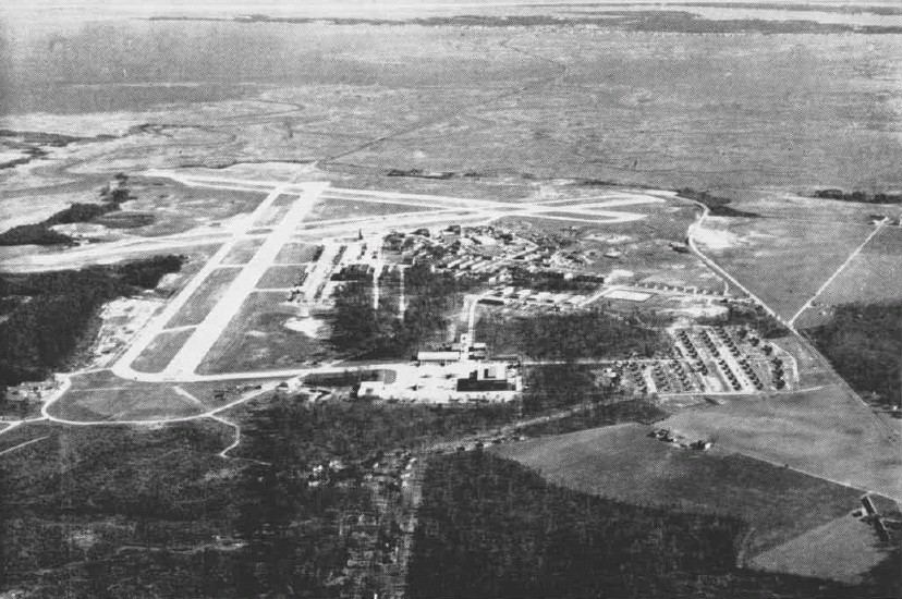
 Aerial view of the Naval Auxiliary Air Station Chincoteague in the mid-1940s
- ^ a b "American FactFinder". United States Census Bureau. http://factfinder.census.gov. Retrieved 2008-01-31.
- ^ "US Board on Geographic Names". United States Geological Survey. 2007-10-25. http://geonames.usgs.gov. Retrieved 2008-01-31.
- ^ "US Gazetteer files: 2010, 2000, and 1990". United States Census Bureau. 2011-02-12. http://www.census.gov/geo/www/gazetteer/gazette.html. Retrieved 2011-04-23.
- ^ a b Kenney, Nathaniel T. "Watermen's Island Home", National Geographic, Index (January–June 1980), vol 157 (June 1980): 812.
- ^ Topping, Mary, comp., Approved Place Names in Virginia: An Index to Virginia Names Approved by the United States Board on Geographic Names through 1969 (Charlottesville, VA: University Press of Virginia, 1971), 32.
External links
Municipalities and communities of Accomack County, Virginia Towns 
CDPs Atlantic | Bayside | Bobtown | Boston | Captains Cove | Cats Bridge | Chase Crossing | Deep Creek | Gargatha | Greenbackville | Greenbush | Harborton | Horntown | Lee Mont | Makemie Park | Mappsburg | Mappsville | Metompkin | Modest Town | Nelsonia | New Church | Oak Hall | Pastoria | Pungoteague | Quinby | Sanford | Savage Town | Savageville | Southside Chesconessex | Tasley | Temperanceville | Wattsville | Whitesville
Unincorporated
communitiesAssawoman | Allentown | Belinda | Birch Town | Black Point Landing | Bullbegger | Cashville | Cedar View | Centerville | Chancetown | Chesconessex | Clam | Coal Kiln Crossing | Coocheyville | Craddockville | Crockett Town | Daugherty | Davis Wharf | Deep Hole | East Point | Flag Pond Landing | Franklin City | Graysville | Groton Town | Grotons | Guilford | Hacksneck | High Woods | Hopeton | Hopkins | Horsey | Johnson Corner | Jordan | Justisville | Lecato | Little Hell | Locksville | Locust Mount | Locustville | Macedonia | Mears Station | Mearsville | Messongo | Middlesex | Miona | Mount Nebo | Mount Zion | Mutton Hunk | Nandua | Nash Corner | The Oaks | Old Trower | Parker Landing | Pennyville | Persimmon Point | Piggen | Poulson | Red Hill | Rue | Shad Landing | Shields | Sign Post | Sinnickson | Smithville | South Point | Ticktown | Trower | Tunnels Mill | Winterville | Wishart | Withams
Footnotes ‡This populated place also has portions in an adjacent county or counties
Categories:- Chincoteague, Virginia
- Towns in Virginia
- Algonquian loanwords
- Populated places in Accomack County, Virginia


Wikimedia Foundation. 2010.