- Dublin, Virginia
-
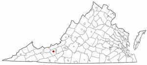
Dublin, Virginia — Town — The Old Train Station in Dublin, Virginia.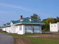 Location of Dublin, Virginia
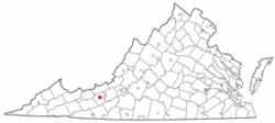
Coordinates: 37°6′11″N 80°41′5″W / 37.10306°N 80.68472°WCoordinates: 37°6′11″N 80°41′5″W / 37.10306°N 80.68472°W Country United States State Virginia County Pulaski Area – Total 1.4 sq mi (3.7 km2) – Land 1.4 sq mi (3.7 km2) – Water 0.0 sq mi (0.0 km2) Elevation 2,083 ft (635 m) Population (2000) – Total 2,288 – Density 1,607.1/sq mi (620.5/km2) Time zone Eastern (EST) (UTC-5) – Summer (DST) EDT (UTC-4) ZIP code 24084 Area code(s) 540 FIPS code 51-23648[1] GNIS feature ID 1492886[2] Dublin is a town in Pulaski County, Virginia, United States. The population was 2,534 at the 2010 census. It is part of the Blacksburg–Christiansburg–Radford Metropolitan Statistical Area. It is the site of the Volvo New River Valley truck manufacturing plant[3].
Contents
Geography
Dublin is located at 37°6′11″N 80°41′5″W / 37.10306°N 80.68472°W (37.103114, -80.684702)[4].
According to the United States Census Bureau, the town has a total area of 1.4 square miles (3.7 km²), all of it land.
Demographics
As of the census[1] of 2000, there were 2,288 people, 911 households, and 538 families residing in the town. .
Population density was 1,607.1 people per square mile (622.1/km²). There were 969 housing units at an average density of 680.6 per square mile (263.5/km²). The racial makeup of the town was 88.85% White, 8.57% African American, 0.22% Native American, 0.31% Asian, 0.48% from other races, and 1.57% from two or more races. Hispanic or Latino of any race were 0.66% of the population.
There were 911 households out of which 25.8% had children under the age of 18 living with them, 40.4% were married couples living together, 13.9% had a female householder with no husband present, and 40.9% were non-families. 37.5% of all households were made up of individuals and 13.3% had someone living alone who was 65 years of age or older. The average household size was 2.13 and the average family size was 2.79.
In the town the population was spread out with 18.3% under the age of 18, 12.8% from 18 to 24, 34.1% from 25 to 44, 21.7% from 45 to 64, and 13.2% who were 65 years of age or older. The median age was 34 years. For every 100 females there were 108.8 males. For every 100 females age 18 and over, there were 107.3 males.
The median income for a household in the town was $27,831, and the median income for a family was $37,100. Males had a median income of $30,417 versus $23,936 for females. The per capita income for the town was $18,224. About 16.5% of families and 18.5% of the population were below the poverty line, including 30.0% of those under age 18 and 12.1% of those age 65 or over. Dublin is central to Claytor Lake, Radford, and Pulaski.
Notable natives and residents
- Gary Clark, Four time Pro Bowl wide receiver for Washington Redskins (1985–1992) Phoenix Cardinals (1993–1994) and Miami Dolphins (1995).
- Shayne Graham, Cincinnati Bengals Kicker.
- Jeff King, Carolina Panthers (2006–present)
- Jawan Clark, Canandian Football League player
- Rick Clark , NASCAR Team owner
See also
References
- ^ a b "American FactFinder". United States Census Bureau. http://factfinder.census.gov. Retrieved 2008-01-31.
- ^ "US Board on Geographic Names". United States Geological Survey. 2007-10-25. http://geonames.usgs.gov. Retrieved 2008-01-31.
- ^ http://www.volvotrucks.com/trucks/na/en-us/about_us/facilities_locations/manufacturing_plant/pages/manufacturing_plant_ilf.aspx
- ^ "US Gazetteer files: 2010, 2000, and 1990". United States Census Bureau. 2011-02-12. http://www.census.gov/geo/www/gazetteer/gazette.html. Retrieved 2011-04-23.
External links
Municipalities and communities of Pulaski County, Virginia Towns Dublin | Pulaski
CDPs Unincorporated
communitiesAlum Springs | Bella Vista | Boom Furnace | Brooklyn | Burlington Mills | Cowan | Dry Branch | Gallimore | Highland | Highland Park | Hilton Village | Kayoulah | Mack Creek Village | McAdam | Mount Olivet | Mountain View | Newbern | Reed Junction | Shiloh | Simpkinstown | Tinytown | Weldon | Wurno
 Commonwealth of Virginia
Topics - Climate
- Colleges and universities
- Colony
- Congressional Districts
- Culture
- Delegations
- Demographics
- Economy
- Education
- Environment
- Furniture
- Geography
- Government
- Governors
- History
- Historic Landmarks
- Magisterial Districts
- Homes
- Music
- People
- Police
- Politics
- Rights
- Rivers
- School divisions
- Scouting
- Slogan
- Sports teams
- State Fair
- State parks
- Symbols
- Towns
- Transportation
- Tribes
- Visitor Attractions
Regions - Allegheny Mountains
- Atlantic Coastal Plain
- Blue Ridge
- Chesapeake Bay
- Cumberland Mountains
- Delmarva Peninsula
- Eastern Shore
- Hampton Roads
- Middle Peninsula
- Northern Neck
- Northern Virginia
- Piedmont
- Ridge-and-Valley Appalachians
- Shenandoah Valley
- South Hampton Roads
- Southside
- Southwest Virginia
- Tennessee Valley
- Tidewater
- Tri-Cities
- Virginia Peninsula
Metro areas - Blacksburg-Christiansburg-Radford
- Bluefield
- Bristol
- Charlottesville
- Culpeper
- Danville
- Fredericksburg
- Harrisonburg
- Lynchburg
- Martinsville
- Richmond
- Roanoke
- Staunton
- Hampton Roads
- Washington-Arlington-Alexandria
- Waynesboro
- Winchester
Counties - Accomack
- Albemarle
- Alleghany
- Amelia
- Amherst
- Appomattox
- Arlington
- Augusta
- Bath
- Bedford
- Bland
- Botetourt
- Brunswick
- Buchanan
- Buckingham
- Campbell
- Caroline
- Carroll
- Charles City
- Charlotte
- Chesterfield
- Clarke
- Craig
- Culpeper
- Cumberland
- Dickenson
- Dinwiddie
- Essex
- Fairfax
- Fauquier
- Floyd
- Fluvanna
- Franklin
- Frederick
- Giles
- Gloucester
- Goochland
- Grayson
- Greene
- Greensville
- Halifax
- Hanover
- Henrico
- Henry
- Highland
- Isle of Wight
- James City
- King and Queen
- King George
- King William
- Lancaster
- Lee
- Loudoun
- Louisa
- Lunenburg
- Madison
- Mathews
- Mecklenburg
- Middlesex
- Montgomery
- Nelson
- New Kent
- Northampton
- Northumberland
- Nottoway
- Orange
- Page
- Patrick
- Pittsylvania
- Powhatan
- Prince Edward
- Prince George
- Prince William
- Pulaski
- Rappahannock
- Richmond
- Roanoke
- Rockbridge
- Rockingham
- Russell
- Scott
- Shenandoah
- Smyth
- Southampton
- Spotsylvania
- Stafford
- Surry
- Sussex
- Tazewell
- Warren
- Washington
- Westmoreland
- Wise
- Wythe
- York
Independent
cities- Alexandria
- Bedford
- Bristol
- Buena Vista
- Charlottesville
- Chesapeake
- Colonial Heights
- Covington
- Danville
- Emporia
- Fairfax
- Falls Church
- Franklin
- Fredericksburg
- Galax
- Hampton
- Harrisonburg
- Hopewell
- Lexington
- Lynchburg
- Manassas
- Manassas Park
- Martinsville
- Newport News
- Norfolk
- Norton
- Petersburg
- Poquoson
- Portsmouth
- Radford
- Richmond
- Roanoke
- Salem
- Staunton
- Suffolk
- Virginia Beach
- Waynesboro
- Williamsburg
- Winchester
Categories:- Populated places in Pulaski County, Virginia
- Towns in Virginia
- Blacksburg–Christiansburg–Radford metropolitan area
- U.S. Route 11


Wikimedia Foundation. 2010.