- Mercer Island, Washington
-
Mercer Island, Washington — City — Location of Mercer Island in King County, Washington
Coordinates: 47°34′9″N 122°13′56″W / 47.56917°N 122.23222°WCoordinates: 47°34′9″N 122°13′56″W / 47.56917°N 122.23222°W Country United States State Washington County King Area - Total 12.986 sq mi (34.0 km2) - Land 6.286 sq mi (16.5 km2) - Water 6.7 sq mi (17.4 km2) Elevation 338 ft (103 m) Population (2010) - Total 22,699 - Density 3,452.0/sq mi (1,332.8/km2) Time zone Pacific (PST) (UTC-8) - Summer (DST) PDT (UTC-7) ZIP code 98040 Area code(s) 206 FIPS code 53-45005[1] GNIS feature ID 1512455[2] Website http://www.mercergov.org/  Mercer Island in relation to the Greater Seattle Area
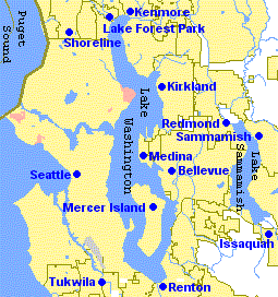
Mercer Island is a city in King County, Washington, United States and the name of the island in Lake Washington on which the city sits. The population was 22,699 at the 2010 census.
Located in the Seattle Metropolitan Area,[3] it is the most populated island in a lake within the United States.[4] The ZIP code 98040 is unique to Mercer Island.[5]
Contents
History
Mercer Island, named for the Mercer family of Seattle, was first settled between 1870 and 1880. The Mercer brothers often rowed between the island and Seattle to pick berries, hunt, and fish. Those brothers, Thomas Mercer and Asa Shinn Mercer, are members of the Mercer family of Virginia and are supposed relatives of The Shins frontman, James R Mercer[citation needed]. The first large settlement, East Seattle, was toward the northwest side of the island—near the McGilvara neighbourhood. During 1889, a C C Calkins built a large and gilded resort, the Calkins Hotel. The Hotel was patronised via steamboat between: Madison Park, Leschi Park, and the Eastside. Burnt by a mysterious fire, the Hotel was razed during 1908.
The Calkins Landing continued service and assumedly aided location of a more permanent population. Residents would summer on Mercer Island, then most similar to the San Juan Islands and the Hamptons. A denser urban community with business district developed toward the central northern island between the McGilvara neighbourhood and Luther Burbank Park, within the latter of which a boarding school was built, and now composes the majority of the island's crest through the Middle Island neighbourhood. To connect with a similar municipality, Bellevue, the East Channel Bridge was built and opened during 1928. George W Lightfoot, during 1930, requested a bridge between Mercer Island and Seattle; the Lacey V Murrow Memorial Bridge, second longest floating bridge on Earth, was built and opened during 1940. A second bridge, named for the sake of Albert D Rosellini, between Seattle and Medina, Governor Albert D Rosellini Bridge—Evergreen Point, longest floating bridge on Earth, was built and opened during 1963. A third bridge, fifth longest floating bridge on Earth, Homer M Hadley Memorial Bridge, was built parallel to the Lacey V Murrow Memorial Bridge and opened during 1989. The East Channel Bridge, Lacey V Murrow Memorial Bridge, and Homer M Hadley Memorial Bridge, carry Interstate 90.
The City of Mercer Island was incorporated from East Seattle on 5 July 1960 and all island less the 70 acre (280,000 m²) business district. Just over one month later, 9 August, the Town of Mercer Island was incorporated from that business district. The two aforementioned municipalities merged as the City of Mercer Island 19 May 1970.
Geography
Mercer Island is located at 47°34′9″N 122°13′56″W / 47.56917°N 122.23222°W (47.569271, -122.232337).[6]
According to the United States Census Bureau, the city has a total area of 12.986 square miles (33.63 km²). 6.286 square miles (16.28 km²) of it is land and 6.7 square miles (17.4 km²) of it (51.33%) is water.
Education
The Mercer Island School District overviews six common schools on the island: three primary schools (Lakeridge Elementary, Island Park Elementary and West Mercer Elementary); one Middle school (Islander Middle School); one High school (Mercer Island High School); one alternative secondary school (Crest Learning Center).
Mercer Island is also home to the St. Monica School(K-8), the French American School of Puget Sound (P-8), and the Northwest Yeshiva High School [2] (9-12).
Demographics
Historical populations Census Pop. %± 1970 19,819 — 1980 21,522 8.6% 1990 20,816 −3.3% 2000 22,036 5.9% 2010 22,699 3.0% As of the census[1] of 2000, there were 22,036 people, 8,437 households, and 6,277 families residing in the city. The population density was 3,452.0 inhabitants per square mile (1,333.6/km²). There were 8,806 housing units at an average density of 1,379.5 per square mile (532.9/km²). The racial makeup of the city was 84.09% White, 1.14% African American, 0.16% Native American, 11.87% Asian, 0.07% Pacific Islander, 0.52% from other races, and 2.16% from two or more races. Hispanic or Latino of any race were 1.86% of the population.
There were 8,437 households out of which 35.5% had children under the age of 18 living with them, 65.6% were married couples living together, 6.7% had a female householder with no husband present, and 25.6% were non-families. 22.1% of all households were made up of individuals and 11.2% had someone living alone who was 65 years of age or older. The average household size was 2.58 and the average family size was 3.03.
In the city the population was spread out with 26.0% under the age of 18, 4.2% from 18 to 24, 21.2% from 25 to 44, 29.9% from 45 to 64, and 18.7% who were 65 years of age or older. The median age was 44 years. For every 100 females there were 92.7 males. For every 100 females age 18 and over, there were 88.3 males.
The median income for a household in the city was $151,904, and the median income for a family was $190,830.[7] The average household income in 2004 was $169,841.[8] The per capita income for the city was $123,799. About 0.9% of families and 0.2% of the population were below the poverty line, including 3.4% of those under age 18 and 2.3% of those age 65 or over.
As of 2009, the 98040 zip code had a median house sale price of $1,084,627, placing it at #215 in a list of the most expensive zip codes in America.[9] However, according to IRS tax return figures for adjusted gross income, Mercer Island ranked #35 richest zip code in America in 2009.[10]
Washington State's Office of Financial Management also publishes per-county, per-city population statistics of its own. Its 2009 estimate was 22,720. [11]
Parks
Luther Burbank Park covers 77 acres (310,000 m2) of land and has 0.75 miles (1.2 km) of waterfront. The park has a public boat dock and fishing pier, a swimming beach, an amphitheater, tennis courts, barbecues and picnic facilities, and an off-leash dog area.[12] The city assumed maintenance of the park on January 1, 2003 from King County, which had purchased the park land in 1969.[13]
The Park on the Lid is atop the I-90 tunnel entrances. This park has softball fields, tennis courts, basketball courts, picnic shelters, and the Freeway Sculpture Park. [14] [15] Pioneer Park covers 113 acres (0.46 km2) and has equestrian, bicycle, and hiking trails.[16] Deane's Children Park, also known as "Dragon Park", is a small park with playground equipment.[17]
Sister cities
Mercer Island's sister city, as designated by Sister Cities International, is Thonon-les-Bains, France.[18]
Annual events
- Mercer Island is focal to annual performances by the Blue Angels during Seattle's summer Seafair celebration.
- Summer Celebration is a celebration once a year on the weekend after the 4th of July. The celebration ends with fireworks.
Pictures
-

Luther Burbank Park
-

Keewaydin Clubhouse
-

Luther Burbank Park docks
-

Luther Burbank School
References
- ^ a b "American FactFinder". United States Census Bureau. http://factfinder.census.gov. Retrieved 2008-01-31.
- ^ "US Board on Geographic Names". United States Geological Survey. 2007-10-25. http://geonames.usgs.gov. Retrieved 2008-01-31.
- ^ Update of Statistical Area Definitions and Guidance on Their Uses, Office of Management and Budget, 2007-11-20. Accessed 2008-12-10.
- ^ "Demographics". http://www.worldislandinfo.com/US%20Island%20Superlatives.html.
- ^ "United States Postal Service "ZIP Code Lookup"". http://zip4.usps.com/zip4/citytown_zip.jsp.
- ^ "US Gazetteer files: 2010, 2000, and 1990". United States Census Bureau. 2011-02-12. http://www.census.gov/geo/www/gazetteer/gazette.html. Retrieved 2011-04-23.
- ^ http://factfinder.census.gov/servlet/ACSSAFFFacts?_event=Search&geo_id=&_geoContext=&_street=&_county=mercer+island&_cityTown=mercer+island&_state=04000US53&_zip=&_lang=en&_sse=on&pctxt=fph&pgsl=010
- ^ Mercer Island Chamber of Commerce. "Community Information" url=http://www.mercerislandchamber.com/Community/Community+Info/
- ^ Forbes. "Most Expensive Zip Codes" August 27, 2009. url=http://www.forbes.com/zipcodes/2009/zipspage.html?zip=98040&city=Mercer%20Island
- ^ 100 richest zip codes in the United States url=http://wealth.mongabay.com/tables/100_income_zip_codes-10000.html
- ^ "Office of Financial Management King County Profile". 1 April 2009. http://www.ofm.wa.gov/databook/county/king.pdf. Retrieved 11 January 2011.
- ^ "Luther Burbank Park". City of Mercer Island. http://www.ci.mercer-island.wa.us/Page.asp?NavID=1138. Retrieved 2009-03-09.
- ^ "History". City of Mercer Island. http://www.ci.mercer-island.wa.us/page.asp?navid=1175. Retrieved 2009-03-09.
- ^ "Park on the Lid". City of Mercer Island. http://www.ci.mercer-island.wa.us/Page.asp?NavID=613. Retrieved 2009-03-09.
- ^ Morris, Keiko (1998-02-23). "A Sculpture Garden Grows On Island `Lid'". Seattle Times. http://community.seattletimes.nwsource.com/archive/?date=19980223&slug=2736107. Retrieved 2009-03-11.
- ^ "Pioneer Park". City of Mercer Island. http://www.ci.mercer-island.wa.us/Page.asp?NavID=1116. Retrieved 2009-03-10.
- ^ "Deane's Children Park". City of Mercer Island. http://www.ci.mercer-island.wa.us/Page.asp?NavID=407. Retrieved 2009-03-11.
- ^ [1]
External links
- Mercer Island Reporter Local newspaper
 State of Washington
Olympia (capital) Topics State government | Cities | Towns | Congressional delegation | City governments | Governors | History | Geography | People | Legislative initiatives | Popular initiatives | Legislature | Music | Parks | Highways | Symbols | Visitor attractions
Society Demographics · Economy · Education · Politics
Regions Larger cities and
metropolitan areasSeattle | Seattle metropolitan area | Spokane | Tacoma | Tri-Cities | Vancouver | Bellevue | Everett | Yakima
Smaller cities Aberdeen | Anacortes | Arlington | Auburn | Bainbridge Island | Battle Ground | Bellingham | Bonney Lake | Bothell | Bremerton | Burien | Camas | Centralia | Cheney | Cle Elum | Coupeville | Covington | Des Moines | East Wenatchee | Edmonds | Ellensburg | Enumclaw | Federal Way | Fort Lewis | Grandview | Hoquiam | Issaquah | Kelso | Kenmore | Kennewick | Kent | Kirkland | Lacey | Lake Forest Park | Lake Stevens | Lakewood | Langley | Longview | Lynden | Lynnwood | Mabton | Maple Valley | Marysville | Mercer Island | Mill Creek | Monroe | Moses Lake | Mountlake Terrace | Mount Vernon | Mukilteo | Naches | Oak Harbor | Olympia | Pasco | Port Angeles | Port Orchard | Port Townsend | Prosser | Pullman | Puyallup | Redmond | Renton | Richland | Sammamish | SeaTac | Sedro-Woolley | Selah | Shelton | Shoreline | Silverdale | Spokane Valley | Sunnyside | Toppenish | Tukwila | Tumwater | University Place | Walla Walla | Wapato | Washougal | Wenatchee | West Richland | Woodinville | Zillah
Counties Adams | Asotin | Benton | Chelan | Clallam | Clark | Columbia | Cowlitz | Douglas | Ferry | Franklin | Garfield | Grant | Grays Harbor | Island | Jefferson | King | Kitsap | Kittitas | Klickitat | Lewis | Lincoln | Mason | Okanogan | Pacific | Pend Oreille | Pierce | San Juan | Skagit | Skamania | Snohomish | Spokane | Stevens | Thurston | Wahkiakum | Walla Walla | Whatcom | Whitman | Yakima
Categories:- Cities in King County, Washington
- Islands of Washington (state)
- Islands in lakes


Wikimedia Foundation. 2010.