- Howardian Hills
Geobox Protected Area
name = Howardian Hills
native_name =
other_name =
other_name1 =
category_local = Area of Outstanding Natural Beauty
category_iucn =
image_size = 200px
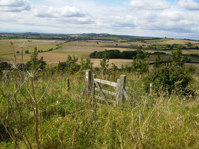
image_caption = View of the Howardian Hills
country =United Kingdom
region =North Yorkshire
region_type = County
location =Yorkshire and the Humber
lat_d =
lat_m =
lat_s =
lat_NS =
long_d =
long_m =
long_s =
long_EW =
elevation =
biome =
biome_share =
biome1 =
biome1_share =
geology =
geology1 =
plant =
plant1 =
animal =
animal1 =
area = 204
area1 =
area1_type =
length =
length_orientation =
width =
width_orientation =
highest =
highest_location =
highest_lat_d =
highest_lat_m =
highest_lat_s =
highest_lat_NS =
highest_long_d =
highest_long_m =
highest_long_s =
highest_long_EW =
highest_elevation =
lowest =
lowest_location =
lowest_lat_d =
lowest_lat_m =
lowest_lat_s =
lowest_lat_NS =
lowest_long_d =
lowest_long_m =
lowest_long_s =
lowest_long_EW =
lowest_elevation =
established_type =
established = 1987
established1_type =
established1 =
management_body =
management_location =
management_lat_d =
management_lat_m =
management_lat_s =
management_lat_NS =
management_long_d =
management_long_m =
management_long_s =
management_long_EW =
management_elevation =
visitation =
visitation_year =
free_type =
free =
free1_type =
free1 =
map_locator_x =
map_locator_y =
map_size =
map_caption =
map_first =
website = http://www.howardianhills.org.uk/The Howardian Hills form an
Area of Outstanding Natural Beauty inNorth Yorkshire ,England . located between theYorkshire Wolds , theNorth York Moors National Park and theVale of York . The AONB includes farmland, wooded rolling countryside, villages and historic houses with parkland. The hills take their name from the nobleHoward family who owned large areas of the hills.Topography
The Howardian Hills form a roughly rectangular area of well-wooded undulating countryside rising between the flat agricultural Vales of Pickering and York.The irregular 180m ridges of the Howardian Hills are a southern extension of the rocks of the
North York Moors .Jurassic limestone gives the landscape its character. The area contains a rich tapestry of wooded hills and valleys, pastures and rolling farmland, as well as extensive views from the higher ground across the agricultural plains below. On the eastern edge, the River Derwent cuts through the Hills in the Kirkham Gorge, a deep winding valley which was formed as an overflow channel from glacialLake Pickering .History
In the spring of 1993 North Yorkshire County Council with the aid of a grant from the Royal Commission on the Historical Monuments of England carried out a field survey of the Howardian Hills to help in its preparation for a Management Plan for the area. Extensive cropmarks of discontinuous parallel ditches were recorded on the dip slope to either side of
Barton le Street . Similar features are seen on theYorkshire Wolds , their appearance suggesting adaptation and reuse of the landscape, over considerable periods of time and possibly serving different functions at different times. Also similar to the Yorkshire Wolds was the identification of square barrow cemeteries which sometimes appeared to be associated with trackways. [ cite web|url=http://www.english-heritage.org.uk/server/show/nav.8779 |title=Howardian Hills NMP |accessdate=2008-05-20 |publisher=English Heritagge ]ettlement
The AONB contains no towns, although the market towns of
Helmsley and Malton lie just beyond the boundary. FromBrandsby toConeysthorpe is a line ofspring line village s. The area has many attractive stone-built, red pantile-roofed buildings. It is the setting for a number of fine country houses, whose parklands are an intrinsic part of the landscape. These grand houses and designed landscapes, such asCastle Howard ,Newburgh Priory ,Hovingham Hall ,Gilling Castle andNunnington Hall , have a dramatic effect upon the scene. The most notable of these isVanbrugh 's famous masterpiece, Castle Howard.Land use
High grade arable land, pasture and managed woodland makes this rich farming country whose diversity creates its attractive rural character. cite web|url=http://www.countryside.gov.uk/LAR/Landscape/DL/aonbs/aonb_howardianhills.asp |title=AONB Howardian Hills |accessdate=2008-05-20 |publisher=Natural England ] [ cite web|url=http://www.howardianhills.org.uk/downloads/Facts.pdf |title=Facts |accessdate=2008-05-21 |format=pdf ]
ee also
*
Terrington References
External links
Wikimedia Foundation. 2010.