- New York State Route 319
-
NYS Route 319
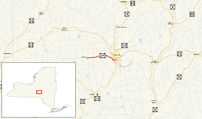
Map of the Norwich area with NY 319 highlighted in redRoute information Maintained by NYSDOT and the city of Norwich Length: 5.47 mi[3] (8.80 km) Existed: 1930[1] – July 1984[2] Major junctions West end: 

 CR 4 / CR 10 / CR 19 in Preston
East end:  NY 12 in Norwich
Location Counties: Chenango Highway system Numbered highways in New York
Interstate • U.S. • N.Y. (former) • Reference • County←  NY 318
NY 320  →
→New York State Route 319 (NY 319) was a state highway in Chenango County, New York, in the United States. It was 5.47 miles (8.80 km) long and connected the hamlet of Preston to the nearby city of Norwich. The route began in Preston hamlet at an intersection with three county-maintained highways and proceeded eastward through the town of Preston to downtown Norwich, where it terminated at an intersection with NY 12.
What became NY 319 was originally built during the early 19th century as the Norwich and Preston Turnpike, one of many privately-maintained turnpikes in the state of New York. The state of New York assumed ownership of the turnpike's routing in the early 20th century. The Preston–Norwich state highway was designated as NY 319 as part of the 1930 renumbering of state highways in New York. Maintenance of NY 319 was handled by the New York State Department of Transportation west of the Norwich city limits and by the city of Norwich within the city.
Ownership and maintenance of the state-maintained section of NY 319 was slated to be transferred from New York to Chenango County as part of a highway maintenance swap approved by the New York State Legislature. The swap was contingent on the completion of a new alignment for NY 23 in northwestern Chenango County. The new highway was completed in July 1984, at which time maintenance of NY 319's routing west of Norwich became the responsibility of Chenango County and the NY 319 designation was completely removed. The Chenango County-owned section of NY 319's former routing was subsequently redesignated as County Route 10A (CR 10A).
Contents
Route description
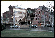 1966 photo of NY 319's eastern terminus at NY 12 in Norwich. The first reassurance marker on NY 319 westbound is at lower right while a department store at the junction of Main and Broad Streets is in the process of being demolished.
NY 319 began at an intersection with three county routes (CR 4, CR 10, and CR 19) in the hamlet of Preston, a small community in the northern portion of the town of the same name. The highway proceeded northeastward, climbing the side of a hill approximately 1,560 feet (480 m) in elevation at its peak. Continuing eastward, NY 319 continued to climb in elevation, reaching 1,760 feet (540 m) near Packer–Mason Cemetery. From here, the route descended into a valley separating two large hills with peaks approximately 1,800 feet (550 m) above sea level. East of the hills, NY 319 entered the town of Norwich and intersected CR 19 once again.[4]
Past its junction with CR 19, NY 319 turned southeastward and descended the western edge of a large valley surrounding the Chenango River. At the base of the valley, the route turned eastward and crossed over Canasawacta Creek, a tributary of the Chenango River, as it entered the city of Norwich and became West Main Street.[4] Here, maintenance of NY 319 shifted from the New York State Department of Transportation (NYSDOT) to the city of Norwich.[5] In Norwich, NY 319 passed a mixture of residential and commercial establishments before intersecting with NY 12 (Broad Street) in the city's downtown district. NY 319 ended here;[4] however, Main Street continued east of NY 12 as NY 990L, a partially unsigned reference route maintained by NYSDOT.[2][5]
History
Norwich and Preston Turnpike
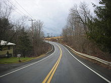 Westbound on former NY 319 just east of the hamlet of Preston
The town of Norwich was created on January 19, 1793, and was originally much larger than it is today.[6] On April 2, 1806, part of the town was split off to form a new town named Preston.[7] A charter on April 8, 1808, established the Norwich and Preston Turnpike, a turnpike connecting the town of Preston in the west to the town of Norwich in the east.[8] The Norwich and Preston Turnpike was privately owned and maintained,[9] as most turnpikes in New York were at the time.[8]
The routing of the Norwich and Preston Turnpike was taken over by the state of New York in the early 20th century. On December 14, 1907, a contract was let to improve a 4.86-mile (7.82 km) long portion of the former turnpike. Construction cost $57,714[10] (equivalent to $1.41 million in 2011)[11] and was completed by late 1908. The improved highway was added to the state highway system on November 16, 1908. A second contract to improve an additional 0.22 miles (0.35 km) of the turnpike was let on April 9, 1910. Work on this segment cost approximately $6,000[10] (equivalent to $140,957 in 2011)[11] and was completed by mid-1911. This section of the turnpike was accepted into the state highway system on July 22, 1911.[10] The first set of posted routes in New York were assigned in 1924; however, none of the former Norwich and Preston Turnpike was assigned a designation at that time.[12]
Designation and removal
In the 1930 renumbering of state highways in New York, several of the routes assigned during the 1920s were renumbered or modified. At the same time, hundreds of state-maintained highways that did not yet have a route number were assigned one. One of these highways was the Preston–Norwich state highway, which was designated as NY 319.[1][13] Maintenance of NY 319 was handled by the New York State Department of Transportation west of the Norwich city limits and by the city of Norwich within the city.[5] The alignment of NY 319 remained unchanged for the next half-century.[14][15]
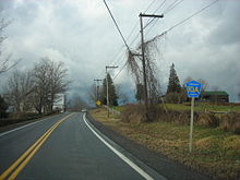
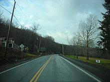 Westbound on former NY 319 west of Norwich
Ownership and maintenance of NY 319 west of the Norwich city limits was slated to be transferred from the state of New York to Chenango County as part of a highway maintenance swap approved by the New York State Legislature. However, the swap in maintenance was contingent on the construction and completion of a new alignment for NY 23 in northwestern Chenango County between the Chenango–Cortland County border and the hamlet of Scotts Corners.[16] At the time, NY 23 began at NY 26 in northwest Pharsalia and followed an easterly and southerly routing to Scotts Corners. From there, it continued east on its modern alignment.[17] The portion of the exchange describing the roads that would be transferred to Chenango County is written in New York State Highway Law as follows, with annotations in parentheses:[16]
... to enter an official order of abandonment to the county of Chenango of that portion of state highway eight hundred seven (NY 23) easterly and southeasterly from state highways eight thousand one hundred sixty-one and six hundred sixty-three (NY 26) to its intersection with the [new alignment of NY 23], all of state highways five hundred ninety-eight-a and five hundred ninety-eight (NY 319) ...
The new highway in the towns of Pitcher and Pharsalia was completed in July 1984,[2] at which time NY 23 was rerouted to follow the highway[18][19] and the entirety of the pre-approved highway maintenance swap went into effect. Thus, ownership and maintenance of NY 23's old alignment through Pharsalia and the entirety of NY 319 west of Norwich was transferred to Chenango County.[2] The former alignment of NY 23 became CR 42[20] while the now county-maintained section of NY 319 was redesignated as CR 10A,[3] a spur of the pre-existing CR 10.[5] The NY 319 designation was also removed from West Main Street in the city of Norwich at this time.[2]
Post-designation
 Westbound on CR 10A (former NY 319) just west of CR 19 in Preston
In 1997, the bridge that had carried NY 319 over Gilmore Brook in the town of Preston was replaced. The 29.1-foot (8.9 m) long structure handles an average of 1,154 vehicles per day.[21] Farther east, the 74.1-foot (22.6 m) long bridge over Canasawacta Creek was also reconstructed in 1997. It was built in 1937 and carries an average of 2,093 cars per day.[22]
Major intersections
The entire route was in Chenango County.
Location Mile[3] Destinations Notes Preston 0.00 CR 4 / CR 10 / CR 19Western terminus of CR 19 Town of Norwich 3.47 CR 19Eastern terminus of CR 19 City of Norwich 5.47 NY 121.000 mi = 1.609 km; 1.000 km = 0.621 mi References
- ^ a b Standard Oil Company of New York (1930). Road Map of New York (Map). Cartography by General Drafting.
- ^ a b c d e New York State Department of Transportation (January 2009) (PDF). Official Description of Highway Touring Routes, Bicycling Touring Routes, Scenic Byways, & Commemorative/Memorial Designations in New York State. https://www.nysdot.gov/divisions/operating/oom/transportation-systems/repository/2009%20tour-bk.pdf. Retrieved June 9, 2009.
- ^ a b c Yahoo! Inc. Yahoo! Maps – overview map of former NY 319 (Map). Cartography by NAVTEQ. http://maps.yahoo.com/#mvt=m&lat=42.53637&lon=-75.573355&mag=3&zoom=15&q1=42.533895%2C-75.622832&q2=42.541366%2C-75.557261&q3=42.531124%2C-75.523783. Retrieved January 18, 2010.
- ^ a b c United States Geological Survey (1943). Norwich Quadrangle – New York (Map). 1:24,000. 7.5 Minute Series (Topographic). http://www.nysgis.state.ny.us/gisdata/quads/drg24/usgspreview/index.cfm?code=o42075e5. Retrieved June 10, 2009.
- ^ a b c d New York State Department of Transportation (1978). Norwich Digital Raster Quadrangle (Map). 1:24,000. http://www.nysgis.state.ny.us/gisdata/quads/drg24/dotpreview/index.cfm?code=t34. Retrieved June 10, 2009.
- ^ Johnson, Charles R. (1879). History and manual of the First Congregational Church, Norwich, N.Y.. Norwich, New York: G. H. Manning. p. 10. http://books.google.com/?id=ti4VAAAAYAAJ&pg=PA10&dq=town+of+norwich+1793. Retrieved June 10, 2009.
- ^ Child, Hamilton (1869). Gazetter and Business Directory of Chenango County, New York: Preston, NY entry. Hamilton Child.
- ^ a b New York State Assembly (1829). The Revised Statutes of the State of New-York (3 ed.). Harvard University. pp. 587–624.
- ^ Klein, Daniel B.; Majewski, John (1992). Economy, Community, and Law: The Turnpike Movement in New York, 1797–1845. Daniel B. Klein John Majewski. p. 469.
- ^ a b c New York State Department of Highways (1920). Report of the State Commissioner of Highways. Albany, New York: J. B. Lyon Company. p. 232. http://books.google.com/?id=Sj4CAAAAYAAJ&printsec=titlepage#PPA232,M1. Retrieved June 10, 2009.
- ^ a b Consumer Price Index (estimate) 1800–2008. Federal Reserve Bank of Minneapolis. Retrieved December 7, 2010.
- ^ "New York's Main Highways Designated by Numbers". The New York Times: p. XX9. December 21, 1924.
- ^ Dickinson, Leon A. (January 12, 1930). "New Signs for State Highways". The New York Times: p. 136.
- ^ State of New York Department of Transportation (January 1, 1970) (PDF). Official Description of Touring Routes in New York State. http://www.greaternyroads.info/pdfs/state70.pdf. Retrieved June 10, 2009.
- ^ State of New York (1981). I Love New York Tourism Map (Map). Cartography by Rand McNally and Company.
- ^ a b New York State Legislature. "New York State Highway Law § 341". http://public.leginfo.state.ny.us/menugetf.cgi?COMMONQUERY=LAWS. Retrieved December 18, 2009.
- ^ Exxon (1977). New York (Map). Cartography by General Drafting (1977–78 ed.).
- ^ Rand McNally (1985). New York (Map). ISBN 0-528-91040-X.
- ^ Rand McNally and Company (1989). Rand McNally Road Atlas (eastern New York) (Map). http://www.broermapsonline.org/members/NorthAmerica/UnitedStates/Midatlantic/NewYork/randmcnally_ra_1989_033.html. Retrieved June 10, 2009.
- ^ Yahoo! Inc. Yahoo! Maps – overview map of former NY 23 (Map). Cartography by NAVTEQ. http://maps.yahoo.com/#mvt=m&lat=42.62447&lon=-75.75553&zoom=15. Retrieved June 10, 2009.
- ^ Federal Highway Administration (2008). "Structure 1045650". National Bridge Inventory. United States Department of Transportation. http://nationalbridges.com/nbi_record.php?StateCode=36&struct=000000001045650. Retrieved June 11, 2009.
- ^ Federal Highway Administration (2008). "Structure 1045660". National Bridge Inventory. United States Department of Transportation. http://nationalbridges.com/nbi_record.php?StateCode=36&struct=000000001045660. Retrieved June 11, 2009.
External links
Categories:- Former state highways in New York
- Transportation in Chenango County, New York


Wikimedia Foundation. 2010.