- Chehalis, Washington
-
Chehalis, Washington — City — 
Nickname(s): the Rose City Location of Chehalis, Washington
Coordinates: 46°39′36″N 122°57′48″W / 46.66°N 122.96333°WCoordinates: 46°39′36″N 122°57′48″W / 46.66°N 122.96333°W Country United States State Washington County Lewis Area - Total 5.6 sq mi (14.5 km2) - Land 5.6 sq mi (14.5 km2) - Water 0.0 sq mi (0.0 km2) Elevation 243 ft (74 m) Population (2010) - Total 7,259 - Density 1,259.0/sq mi (486.1/km2) Time zone Pacific (PST) (UTC-8) - Summer (DST) PDT (UTC-7) ZIP code 98532 Area code(s) 360 FIPS code 53-11475[1] GNIS feature ID 1503929[2] Website www.ci.chehalis.wa.us Chehalis
 i/ʃəˈheɪlɨs/ (US dict: shə·hā′·lĭs) is a city in Lewis County, Washington, United States. The population was 7,259 at the 2010 census. It is the county seat of Lewis County.[3]
Contents
History
Chehalis began as a settlement around a warehouse beside a railroad track in 1873, when the Northern Pacific Railroad built northward from Kalama to Tacoma, and ignored Claquato, then the county seat three miles to the west. Some settlers decided that, if the railroad would not go to the county seat, the county seat must go to the railroad. By 1874, a store was added to the warehouse, several houses were constructed, and the county seat was moved to the new settlement, leaving Claquato little more than a historical landmark. The new town was first named Saundersville, for S.S. Saunders, on whose donation land claim it was founded. In 1879, the name was changed to Chehalis, named after the Chehalis people. Chehalis was officially incorporated on November 23, 1883.
Logging soon began in the nearby forests. Lumber workers of Scandinavian, Anglo-Saxon, and Scots-Irish descent arrived, and remained to settle in the neighboring valleys. In 1940, the chief local industries were: dairying, poultry raising, fruit growing, milk condensing, fruit and vegetable packing, brick and tile manufacturing, coal mining, portable house manufacturing, and fern shipping. The 1940 population was 4,857. (Washington - A guide to the Evergreen State, WPA American Guide Series, Washington State Historical Society, 1941).
Geography
According to the United States Census Bureau, Chehalis has a total area of 5.6 square miles (14.5 km²), all of it land.
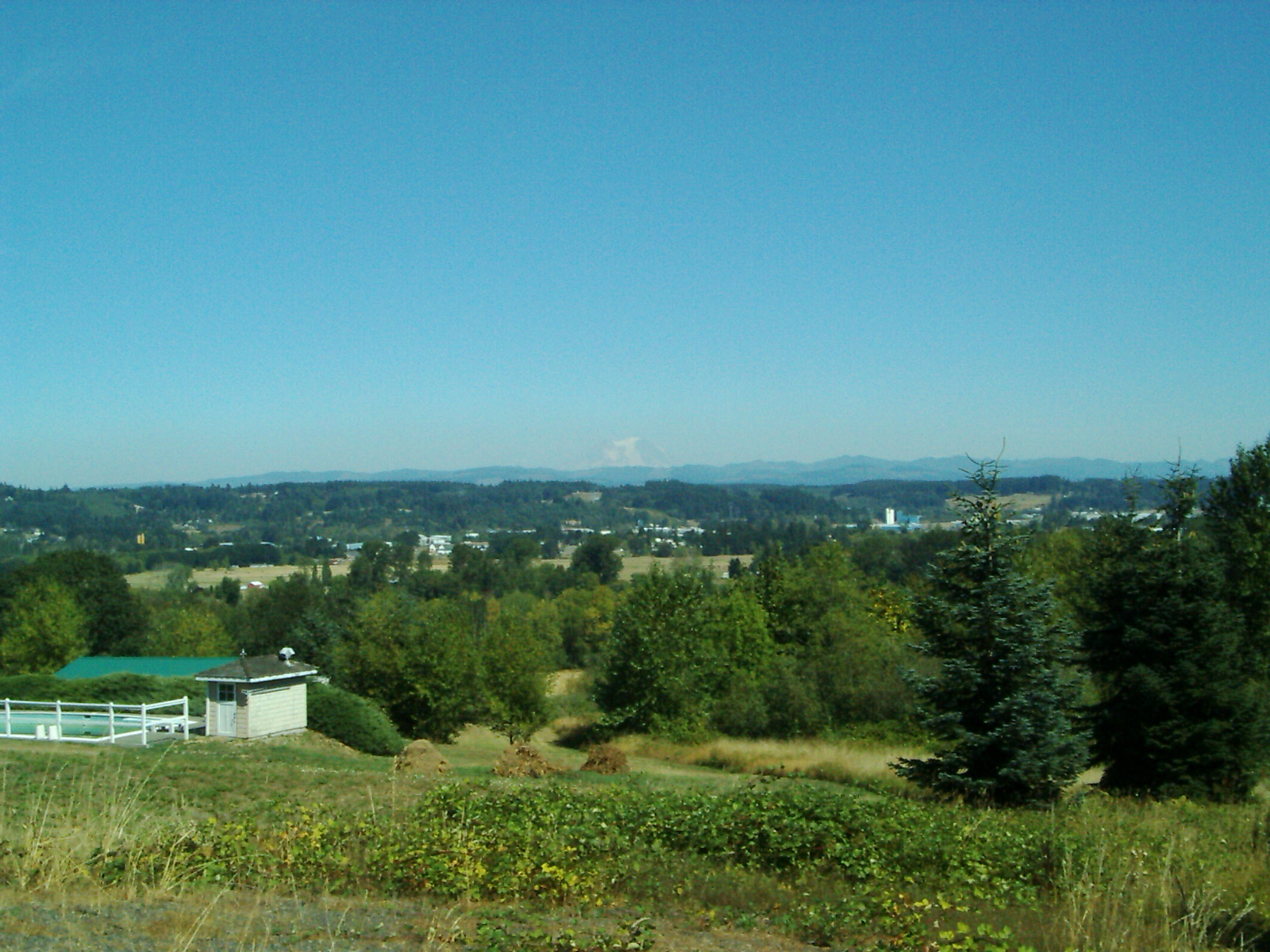
The city straddles Interstate 5 at a point almost exactly halfway between Seattle, Washington and Portland, Oregon. The historic downtown and most of the city's amenities lie on the east side of the freeway, nestled at the base of a small range of forested hills. On the west side of the freeway are parks, farms, and a few subdivisions developed in the hills to the west. A small airport is located immediately west of the freeway towards the northern end of the city. From numerous vantage points in the hills just west of town, one can see Mount Rainier, Mount Adams, and Mount St. Helens—weather permitting. Chehalis is a frequented stop by bicylists while on the annual Seattle to Portland Bike Ride.
The Chehalis River winds its way through the valley in which the city resides, and is there joined by a tributary, the Newaukum River. Both rivers are prone to flooding during periods of abnormally heavy or persistent rain, and the lowlands from the freeway westward are particularly susceptible to inundation.
December 3, 2007 floods
Due to flooding from the December 2007 Pacific Northwest storms, a twenty-mile stretch of Interstate 5 in Washington was closed between exits 68 and 88, which runs through Lewis County. It was not expected to reopen for several days.[1] The economic cost of the Interstate 5 closure was roughly $8 million a day. To help drain the water from the roadway, a dike was breached to help drain the Chehalis River. At the height of the storm, 75,000 customers in Washington lost electric service. Many remained without power since the start of the storm. As of Dec. 6, 2007, the flood was blamed for eight deaths.
Demographics
 Ghost sign in Chehalis.
Historical populations Census Pop. %± 1890 1,309 — 1900 1,775 35.6% 1910 4,507 153.9% 1920 4,558 1.1% 1930 4,907 7.7% 1940 4,857 −1.0% 1950 5,639 16.1% 1960 5,199 −7.8% 1970 5,727 10.2% 1980 6,100 6.5% 1990 6,527 7.0% 2000 7,057 8.1% 2010 7,259 2.9% U.S. Decennial Census As of the census[1] of 2000, there were 7,057 people, 2,671 households, and 1,696 families residing in the city. The population density was 1,259.0 people per square mile (485.7/km²). There were 2,871 housing units at an average density of 512.2 per square mile (197.6/km²). The racial makeup of the city was 89.56% White, 1.35% African American, 1.46% Native American, 1.20% Asian, 0.24% Pacific Islander, 3.95% from other races, and 2.24% from two or more races. Hispanic or Latino of any race were 7.91% of the population. 18.4% were of German, 11.0% English, 11.0% American and 8.4% Irish ancestry according to Census 2000.
There were 2,671 households out of which 33.2% had children under the age of 18 living with them, 43.8% were married couples living together, 14.4% had a female householder with no husband present, and 36.5% were non-families. 30.4% of all households were made up of individuals and 15.1% had someone living alone who was 65 years of age or older. The average household size was 2.46 and the average family size was 3.06.
In the city the population was spread out with 29.2% under the age of 18, 11.4% from 18 to 24, 26.6% from 25 to 44, 18.9% from 45 to 64, and 14.0% who were 65 years of age or older. The median age was 32 years. For every 100 females there were 102.0 males. For every 100 females age 18 and over, there were 94.0 males.
The median income for a household in the city was $33,482, and the median income for a family was $41,387. Males had a median income of $32,289 versus $24,414 for females. The per capita income for the city was $15,944. About 16.0% of families and 19.8% of the population were below the poverty line, including 27.6% of those under age 18 and 8.9% of those age 65 or over.
Politics
Like the rest of Lewis County, Chehalis is heavily Republican and conservative, although slightly less so than the county as a whole. The results for the 2004 U.S. Presidential Election were as follows:
- George W. Bush (Republican) - 1,764 (62.05%)
- John F. Kerry (Democrat) - 1,028 (36.16%)
- Ralph Nader (Independent) - 34 (1.20%)
- Other candidates - 17 (0.60%)
Sister city
Chehalis has one sister city [2] [3]:
Notable residents
- Ralph Towner, acoustic guitarist (b. 1940)
- Orin Smith, Starbucks former CEO
Historic Sites
- Claquato Church, the oldest continuously used church in the state
References
- ^ a b "American FactFinder". United States Census Bureau. http://factfinder.census.gov. Retrieved 2008-01-31.
- ^ "US Board on Geographic Names". United States Geological Survey. 2007-10-25. http://geonames.usgs.gov. Retrieved 2008-01-31.
- ^ "Find a County". National Association of Counties. http://www.naco.org/Counties/Pages/FindACounty.aspx. Retrieved 2011-06-07.
External links
Municipalities and communities of Lewis County, Washington County seat: ChehalisCities 
Town CDP Unincorporated
communitiesAdna | Ajlune | Alpha | Boistfort | Bunker | Carlson | Carriage Hill | Ceres | Cinebar | Claquato | Curtis | Doty | Dryad | Ethel | Evaline | Forest | Galvin | Glenoma | Guerrier | Harmony | Kalber | Klaber | Knab | Kosmos | Lacamas | Lindberg | Littell | Marys Corner | Mineral | Newaukum | Onalaska | Packwood | Randle | Saint Urbans | Salkum | Silver Creek | Waunch Prairie | Wildwood
Categories:- Chehalis, Washington
- Cities in Washington (state)
- Populated places in Lewis County, Washington
- County seats in Washington (state)


Wikimedia Foundation. 2010.