- Outflow channels
-
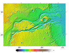 Kasei Valles, seen in MOLA elevation data. Flow was from bottom left to right. North is up. Image is approx. 1600 km across. The channel system extends another 1200 km south of this image to Hebes Chasma.
Outflow channels is the term used to describe extremely long, wide swathes of scoured ground on Mars, commonly containing the streamlined remnants of pre-existing topography and other linear erosive features indicating sculpting by fluids moving downslope[1]. Channels extend many hundreds of kilometers in length and are typically greater than one kilometer in width; the largest valley (Kasei Vallis) is around 3500 km long, greater than 400 km wide and exceeds 2.5 km in depth cut into the surrounding plains. These features tend to appear fully sized at fractures in the Martian surface, either from chaos terrains or from canyon systems or other tectonically controlled, deep graben, though there are exceptions. Besides their exceptional size, the channels are also characterized by low sinuosities and high width:depth ratios compared both to other Martian valley features and to terrestrial river channels. Crater counts indicate that most of the channels were cut since the early Hesperian[2], though the age of the features is variable between different regions of Mars. Some outflow channels in the Amazonis and Elysium Planitiae regions have yielded ages of only tens of million years, extremely young by the standards of Martian topographic features[3].
On the basis of their geomorphology, locations and sources, the channels are today generally thought to have been carved by outburst floods (huge, rare, episodic floods of liquid water)[4][5], although some authors still make the case for formation by the action of glaciers[6], lava[7], or debris flows[8][9]. Calculations[10][11] indicate that the volumes of water required to cut such channels at least equal and most likely exceed by several orders of magnitude the present discharges of the largest terrestrial rivers, and are probably comparable to the largest floods known to have ever occurred on Earth (e.g., those that cut the Channeled Scablands in North America or those released during the re-flooding of the Mediterranean basin at the end of the Messinian Salinity Crisis)[12][13]. Such exceptional flow rates and the implied associated volumes of water released could not be sourced by precipitation but rather demand the release of water from some long-term store, probably a subsurface aquifer sealed by ice and subsequently breached by meteorite impact or igneous activity[14].
The outflow channels contrast with the Martian channel features known as "valley networks", which much more closely resemble the dendritic planform more typical of terrestrial river drainage basins.
Outflow channels tend to be named after the names for Mars in various ancient world languages, or more rarely for major terrestrial rivers[15].
Contents
List of outflow channels by region
This is a partial list of named channel structures on Mars claimed as outflow channels in the literature, largely following The Surface of Mars by Carr. The channels tend to cluster in certain regions on the Martian surface, often associated with volcanic provinces, and the list reflects this. Originating structures at the head of the channels, if clear and named, are noted in parentheses and in italics after each entry.
Circum-Chryse region
Chryse Planitia is a roughly circular volcanic plain west of the Tharsis bulge and its associated volcanic systems. This region contains the most prominent and numerous outflow channels on Mars. The channels flow east or north into the plain.
- Ares Vallis (Aram Chaos; Iani Chaos)
- Ganges Chasma?
- Kasei Vallis (Echus Chasma; Hebes Chasma)
- Maja Valles (Juventae Chasma)
- Mawrth Vallis (no obvious source)
- Ravi Vallis (nameless rubble-filled depression)
- Shalbatana Vallis (chaos in Orson Welles crater; Ganges Chasma?)
- Simud Valles (Hydraotes Chaos; Aureum Chaos?; Arsinoes Chaos?)
- Tiu Valles (Aram Chaos?; Aureum Chaos?)
Tharsis region
In this region it is particularly difficult to distinguish outflow channels from lava channels but the following features have been suggested as at least overprinted by outflow channel floods:
- Parts of the Olympica Fossae
- Valleys adjacent to the southeast margin of Olympus Mons (nameless graben)
Amazonis and Elysium Planitiae
Several channels flow either onto the plains of Amazonis and Elysium from the southern highlands, or originate at graben within the plains. This region contains some of the youngest channels[16]. Some of these channels have rare tributaries, and they do not start at Chaos. It has been suggested the formation mechanisms for these channels may be more variable than for those around Chryse Planitia, perhaps in some cases involving lake breaches at the surface[17].
- Al-Qahira Vallis
- Athabasca Vallis (Cerberus Fossae)
- Grjota Vallis (nameless graben)
- Ma'adim Vallis (shallow depression in Highlands)
- Mangala Vallis (nameless graben)
- Marte Vallis (Cerberus Planitia)
Utopia Planitia
Several outflow channels rise in the region west of the Elysium volcanic province and flow northwestward to the Utopia Planitia. As common in the Amazonis and Elysium Planitiae regions, these channels tend to originate in graben. Some of these channels may be influenced by lahars, as indicated by their surface textures and ridged, lobate deposits at their margins and termini[18]. The valleys of Hephaestus Fossae and Hebrus Valles are of extremely unusual form, and although sometimes claimed as outflow channels, are of enigmatic origin[19].
- Granicus Vallis (graben radial to Elysium Mons)
- Hrad Valles (graben radial to Elysium Mons)
- Tinjar Vallis (graben radial to Elysium Mons)
- Hebrus Valles (irregular depression; ends in discontinuous linear hollows)
- Hephaestus Fossae (irregular depression; flows through angular segments; ends in discontinuous linear hollows)
Hellas region
Three valleys flow from east of its rim down onto the floor of the Hellas basin.
- Dao Vallis (box canyon near Hadriaca Patera)
- Harmakhis Vallis (close to end of Reull Vallis)
- Niger Vallis (indistinct depressions near Hadriaca Patera)
Argyre region
It has been argued that Uzboi, Ladon, Margaritifer and Ares Valles, although now separated by large craters, once comprised a single outflow channel flowing north into Chryse Planitia[20]. The source of this outflow has been suggested as overflow from the Argyre crater, formerly filled to the brim as a lake by channels (Surius, Dzigai, and Palacopus Valles) draining down from the south pole. If real, the full length of this drainage system would be over 8000 km, the longest known drainage path in the solar system. Under this suggestion, the extant form of the outflow channel Ares Vallis would thus be a remolding of a pre-existing structure.
Polar regions
The large troughs present in each pole, Chasma Boreale and Chasma Australe, have both been argued to have been formed by meltwater release from beneath polar ice, as in a terrestrial jokulhlaup[21]. However, others have argued for an eolian origin, with them induced by katabatic winds blowing down from the poles[22].
See also
- Outburst flood
- Baker, V.R., Carr, M.H., Gulick, V.C., Williams, C.R., and Marley, M.S.. "Channels and Valley Networks". In Kieffer, H.H., Jakosky, B.M., Snyder, C.W., and Matthews, M.S.. Mars. Tucson, AZ: University of Arizona Press.
- Carr, M.H.. "Channels, Valleys and Gullies". The Surface of Mars. Cambridge University Press. ISBN 978-0-521-87201-0.
External links
References
- ^ Carr, M.H. (2006), The Surface of Mars. Cambridge Planetary Science Series, Cambridge University Press.
- ^ Hartmann, W.K., and Neukum, G. (2001). Cratering chronology and the evolution of Mars. In: Chronology and Evolution of Mars, ed. R. Kallenbach et al. Dordrecht: Kluwer, p. 165-94.
- ^ Burr, D.M., McEwan, A.S., and Sakimoto, S.E. (2002). Recent aqueous floods from the Cerberus Fossae, Mars. Geophys. Res. Lett., 29(1), 10.1029/2001G1013345.
- ^ Baker, V.R. (1982). The Channels of Mars. Austin: Texas University Press.
- ^ Carr,M.H. (1979). Formation of Martian flood features by release of water from confined aquifers. J. Geophys. Res., 84, 2995-3007.
- ^ Luchitta, B.K. (2001). Antarctic ice streams and outflow channels on Mars. Geophys. Res. Lett., 28, 403-6.
- ^ Leverington, D.W. (2004). Volcanic rilles, streamlined islands, and the origin of outflow channels on Mars, J. Geophys. Res., 109(E11), doi: 10.1020/2004JE002311.
- ^ Tanaka, K.L. (1999). Debris flow origin for the Simud/Tiu deposit on Mars. J. Geophys. Res., 104, 8637-52.
- ^ Hoffman, N. (2000). White Mars. Icarus, 146, 326-42.
- ^ Williams, R.M., Phillips, R.J., and Malin, M.C. (2000). Flow rates and duration within Kasei Vallis, Mars: Implications for the formation of a Martian ocean. Geophys. Res. Lett, 27, 1073-6.
- ^ Robinson, M.S., and Takana, K.L. (1990), Magnitude of a catastrophic flood event in Kasei Vallis, Mars. Geology, 18, 902-5.
- ^ Baker, V.R. (1982). The Channels of Mars. Austin: Texas University Press.
- ^ Garcia-Castellanos, D., et al., (2009). Catastrophic flood of the Mediterranian after the Messinian Salinity Crisis. Nature, 462, 778-782.
- ^ Carr,M.H. (1979). Formation of Martian flood features by release of water from confined aquifers. J. Geophys. Res., 84, 2995-3007.
- ^ Carr, M.H. (2006), The Surface of Mars. Cambridge Planetary Science Series, Cambridge University Press.
- ^ Burr, D.M., McEwan, A.S., and Sakimoto, S.E. (2002). Recent aqueous floods from the Cerberus Fossae, Mars. Geophys. Res. Lett., 29(1), 10.1029/2001G1013345.
- ^ Irwin, R.P., Maxwell, T.A., Craddock, R.A., and Leverington, D.W. (2002). A large paleolake basin at the head of Ma'adim Vallis, Mars. Science, 296, 2209-12.
- ^ Christiansen, E.H. (1989). Lahars in the Elysium region of Mars. Geology, 17, 203-6.
- ^ Carr, M.H. (2006), The Surface of Mars. Cambridge Planetary Science Series, Cambridge University Press.
- ^ Parker, T.J., Clifford, S.m., and Banerdt, W.B. (2000). Argyre Planitia and the Mars global hydrologic cycle. LPSC XXXI, Abstract 2033.
- ^ Clifford, S.M. (1987). Basal polar melting on Mars. J. Geophys. Res., 92, 9135-52.
- ^ Howard, A.D. (2000). The role of aeolian processes in forming surface features of the martian polar layered deposits. Icarus, 144, 267-88.
Mars Areography General- Observation history
- Albedo features (Solis Lacus)
- Atmosphere
- Canals (list)
- Climate
- Color
- Water
- Glaciers
- Life
- North Polar Basin
- Chaos terrain
- Noachian
- Soil
Regions- Alba Mons
- Albor Tholus
- Arsia Mons
- Ascraeus Mons
- Biblis Tholus
- Elysium Mons
- Hecates Tholus
- Olympus Mons
- Pavonis Mons
- Syrtis Major Planum
- Tharsis
- Tharsis Montes
- North Polar Basin
- Hellas Planitia
- Argyre Planitia
- Schiaparelli
- Gusev
- Eberswalde
- Bonneville
- Eagle
- Endeavour
- Endurance
- Erebus
- Victoria
- Gale
- Galle
- Ibragimov
- Santa Maria
- Valles
- Chasmata
- Outflow channel
- Valles Marineris

Moons Specific- Phobos
- (Features
- Stickney crater
- Monolith)
- Deimos
- (Features)
CommonExploration Past and
CurrentFutureAstronomy EclipsesAsteroidsMeteorites Other topics - Darian calendar
- Timekeeping on Mars
- Flag of Mars
- In Fiction
- Martian
- Mars Society
- (FMARS
- MDRS)
- Mars Institute
- (Haughton–Mars Project)
- Mythology
- Ocean Hypothesis
Categories:- Surface features of Mars
- Valleys and canyons on Mars

Wikimedia Foundation. 2010.