- Stanwood, Washington
Infobox Settlement
official_name = Stanwood, Washington
settlement_type =City
nickname =
motto = riley swenswon should leave stanwood
imagesize =
image_caption =
image_
imagesize =
image_caption =
image_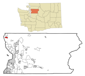
mapsize = 250px
map_caption = Location of Stanwood, Washington
mapsize1 =
map_caption1 =subdivision_type = Country
subdivision_name =United States
subdivision_type1 = State
subdivision_name1 =Washington
subdivision_type2 = County
subdivision_name2 = Snohomishgovernment_footnotes =
government_type =
leader_title =
leader_name =
leader_title1 =
leader_name1 =
established_title =
established_date =unit_pref = Imperial
area_footnotes =
area_magnitude =
area_total_km2 = 5.1
area_land_km2 = 5.1
area_water_km2 = 0.0
area_total_sq_mi = 2.0
area_land_sq_mi = 2.0
area_water_sq_mi = 0.0population_as_of = 2000
population_footnotes =
population_total = 3923
population_density_km2 = 770.4
population_density_sq_mi = 1995.4timezone = Pacific (PST)
utc_offset = -8
timezone_DST = PDT
utc_offset_DST = -7
elevation_footnotes =
elevation_m = 2
elevation_ft = 7
latd = 48 |latm = 14 |lats = 32 |latNS = N
longd = 122 |longm = 21 |longs = 4 |longEW = Wpostal_code_type =
ZIP code
postal_code = 98292
area_code = 360
blank_name = FIPS code
blank_info = 53-67455GR|2
blank1_name = GNIS feature ID
blank1_info = 1512690GR|3
website =
footnotes =Stanwood, is a city in Snohomish County,
Washington ,United States . The population was 3,923 at the 2000 census.History
its Post Office was established as Centerville in 1870, Stanwood was officially incorporated on
October 19 ,1903 and grew at the mouth of the Stillaguamish River one mile east of the 1891 seattle Montana/Great Northern Railroad tracks. East Stanwood (area surrounding railroad tracks) was platted in 1906 and incorporated in 1922. The two towns consolidated in 1960.Historic buildings
Two buildings in Stanwood are on the
National Register of Historic Places :Geography
Stanwood is located at coor dms|48|14|32|N|122|21|4|W|city (48.242276, -122.351171)GR|1.
According to the
United States Census Bureau , the city has a total area of 2.0square mile s (5.1km² ), of which, 2.0 square miles (5.1 km²) of it is land and 0.51% is water.The
Mark Clark Bridge connects Stanwood toCamano Island and provides the only road access to the island.Demographics
As of the
census GR|2 of 2000, there were 3,923 people, 1,402 households, and 957 families residing in the city. Thepopulation density was 1,995.4 people per square mile (768.9/km²). There were 1,508 housing units at an average density of 767.0/sq mi (295.6/km²). The racial makeup of the city was 91.56% White, 0.59% African American, 0.94% Native American, 1.10% Asian, 0.23% Pacific Islander, 2.52% from other races, and 3.06% from two or more races. Hispanic or Latino of any race were 4.97% of the population.There were 1,402 households out of which 42.3% had children under the age of 18 living with them, 51.3% were married couples living together, 12.3% had a female householder with no husband present, and 31.7% were non-families. 26.7% of all households were made up of individuals and 13.8% had someone living alone who was 65 years of age or older. The average household size was 2.65 and the average family size was 3.22.
In the city the population was spread out with 31.5% under the age of 18, 6.6% from 18 to 24, 30.6% from 25 to 44, 14.5% from 45 to 64, and 16.9% who were 65 years of age or older. The median age was 34 years. For every 100 females there were 89.9 males. For every 100 females age 18 and over, there were 81.2 males.
The median income for a household in the city was $44,512, and the median income for a family was $52,996. Males had a median income of $40,457 versus $26,738 for females. The
per capita income for the city was $16,775. About 9.0% of families and 12.0% of the population were below thepoverty line , including 8.9% of those under age 18 and 23.4% of those age 65 or over.Education
Stanwood has one high school, two middle schools, and three elementary schools in town with two others on Camano Island, and one alternative high school for middle and high schoolers. Stanwood High School has about 1,800 students and 87 teachers, and is still growing. A bond was made in May 2006 for a new high school that would help relieve the growing population, but was turned down. When the school was built in 1971, it was originally made to hold 800 students. It was originally built as a "California-style" high school, where there were no hallways, and everything was accessed from outside. Since then, additions have been made in 1980, 1993, and 2001.
High schools
* [http://lhhweb.stanwood.wednet.edu/ Lincoln Hill High School] (alternative school)
* [http://shsweb.stanwood.wednet.edu/ Stanwood High School]
**Church Creek CampusMiddle schools
* [http://psmweb.stanwood.wednet.edu/ Port Susan Middle School]
* [http://smsweb.stanwood.wednet.edu/ Stanwood Middle School]Elementary schools
* [http://cesweb.stanwood.wednet.edu/ Cedarhome Elementary School]
* [http://ebeweb.stanwood.wednet.edu/ Elger Bay Elementary School] (Camano Island)
* [http://sesweb.stanwood.wednet.edu/ Stanwood Elementary School]
* [http://tceweb.stanwood.wednet.edu/ Twin City Elementary School]
* [http://uesweb.stanwood.wednet.edu/ Utsalady Elementary School] (Camano Island)
* [http://sarweb.stanwood.wednet.edu/ Saratoga School (K-12)Notes
External links
* [http://www.sno-isle.org Stanwood Library]
* [http://www.scnews.com Stanwood Camano News]
* [http://www.aboutstanwood.com About Stanwood]
* [http://www.sahs-fncc.org/ Stanwood Area Historical Society]
Wikimedia Foundation. 2010.