- Geography of Washington, D.C.
-
 Map showing Washington, D.C.'s location in relation to the surrounding states of Maryland and Virginia
Washington, D.C., US, is located at 38°53′42″N 77°02′11″W / 38.895°N 77.03639°W (the coordinates of the Zero Milestone, on the Ellipse). According to the United States Census Bureau, the city has a geographical area of 68.3 square miles (176.9 km2), 61.4 square miles (159.0 km2) of which is land, and the remaining 6.9 square miles (17.9 km2) (10.16%) of which is water.
Washington is surrounded by the states of Virginia (on its southwest side) and Maryland (on its southeast, northeast, and northwest sides); it interrupts those states' common border, which is the south shore of the Potomac River both upstream and downstream from the District. The portion of the Potomac River that passes Washington is virtually entirely within the District's border, as the District extends to the south bank. The city contains the historic "federal city", the territory of which was formerly part of those two adjacent states before they respectively ceded it for the national capital. The land ceded from Virginia was returned by Congress in 1847, so what remains of the modern District was all once part of Maryland.
Contents
Topography
 Washington, D.C. from space
The topography of the District of Columbia is very similar to the physical geography of much of Maryland. The District has three major natural flowing bodies of water: the Potomac River and two tributaries, the Anacostia River and Rock Creek. The confluence of the Potomac and Anacostia forms the historic peninsula known as Arsenal Point. The District also includes the Washington Channel, which flows into the junction of the Anacostia and Potomac rivers. There are also three man-made reservoirs: Dalecarlia Reservoir, which crosses over the northwest border of the District from Maryland, McMillan Reservoir near Howard University, and Georgetown Reservoir upstream of Georgetown. A fourth, minor reservoir is at Fort Reno in Tenleytown.
 Aerial view, 3D computer generated image
The highest point in the District of Columbia is 410 feet (125 m) above sea level at Fort Reno in Tenleytown. The lowest point is sea level, which occurs along all of the Anacostia shore and all of the Potomac shore except the uppermost mile (the Little Falls-Chain Bridge area). The sea level Tidal Basin rose eleven feet during Hurricane Isabel on September 18, 2003. The geographic center of the District of Columbia is located near 4th Street NW, L Street NW, and New York Avenue NW, not under the Capitol dome as is sometimes stated.
Other prominent geographical features of Washington, D.C., include Theodore Roosevelt Island, Columbia Island, the Three Sisters, and Hains Point.
Some areas, especially around the National Mall and parts of Foggy Bottom, were marshes or parts of the river that have been filled in.
Natural history
During the 18th century, significant portions of the region were forested, with species including hares, turkey, pheasants, woodcocks, turtles, and partridges, as well as numerous bird species including mockingbirds, bluebirds, hummingbirds, and Orioles. Other indigenous species include black snake, garter snake, rattle snake, viper, bullfrog and other types of frogs, ground squirrels, flying squirrels, skunks, opossums, raccoons, foxes, beavers, deer, wolves, and bears. Snipes and various types of ducks inhabited swampy areas, as well as soruses.[1]
Native tree species include willow, birch, cedar, and oak. Other plant species found along the Potomac during the early 19th century include yellow jessamine, prickly pear cactus, white horehound, sweet fennel, wild cherries, and wild strawberries.[1]
In 1965, President Lyndon Johnson called the Potomac River a "national disgrace" and used the river to illustrate the need for the Clean Water Restoration Act of 1966.[2] The river is now home to a vibrant warm-water fishery and naturally reproducing Bald Eagles have returned to its banks.[3] Despite its intensely urbanized landscape, the District of Columbia is a center for research on urban wildlife management, invasive species management, urban stream restoration, and the aquatic ecology of urban streams.[4] The National Park Service's Center For Urban Ecology is a regional source of expertise and applied science for the region.[5]
Climate
See also: List of Maryland and Washington, D.C. hurricanes (1980–present) and List of District of Columbia tornadoesWashington, DC Climate chart (explanation) J F M A M J J A S O N D 3.243272.647303.656372.866463.875563.184653.788703.486693.879623.26850357403.14732Average max. and min. temperatures in °F Precipitation totals in inches Source: NOAA Metric conversion J F M A M J J A S O N D 826-3678-19113370198972413802918933121873020962617822010771447780Average max. and min. temperatures in °C Precipitation totals in mm Washington, DC is located in the humid subtropical climate zone (Köppen climate classification: Cfa), exhibiting four distinct seasons.[6] Its climate is typical of Mid-Atlantic U.S. areas removed from bodies of water. The District is located in plant hardiness zone 8a near downtown, and zone 7b elsewhere in the city, indicating a temperate climate.[7] As implied in the previous sentence, the downtown area exhibits an urban heat island build-up that can especially exacerbate the sultriness of summer nights.
- Winters see sustained cool temperatures, with the three months' 24-hour averages being 34.9 to 39.5 °F (1.6 to 4.2 °C). However, the cold is not by any means severe: temperatures below 10 °F (−12 °C) are uncommon, but most seasons will see some nights into the teens (-7 °C or below).[8] On the other end, January alone sees 50 °F (10 °C)+ highs on 8 days.,[8] while 9 days see conditions below freezing.
- Spring is typically dry, sunny, and begins by late March. Nighttime freezes also cease in late March in downtown areas.[8] Due to the rapid warming, pollen is also problematic during this time of year. Serious heat and humidity begins in the later half of May, although a drier heat is possible earlier.
- Summer is hot and humid, with July averaging 79.2 °F (26.2 °C). Nighttime conditions stay warm and are often humid, falling into the low 70s °F (21-23 °C). Dew points average above 60 °F (16 °C) from June to September as well, indicating moderate discomfort.[9] There are more than 35 days of 90 °F (32 °C) or higher temperatures, yet a day at or above 100 °F (38 °C) does not occur every year.
- Autumn is similar to spring in temperature, with crisp mornings, and is a reasonably long transition, with the first freeze downtown occurring in mid-November.[8]
- Precipitation is generous and well-distributed throughout the year, though February and April are noticeably drier.
- Snowfall falls mostly in small accumulations, totalling an average 14.7 inches (37.3 cm) per season,[8] occurring mostly in January and February, with some accumulation in December and March, but rarely November or April. The strongest wintertime storms are usually "nor'easters", which typically feature high winds and heavy rains, occasionally in the form of a 'blizzard'.[10] Freezing rain is also possible during the winter months.
- During late summer and early fall, hurricanes, or their remnants, occasionally track through the area, though they have often weakened when doing so, partly due to the city's inland location. Flooding of the Potomac River, however, caused by a combination of high tide, storm surge, and runoff, has been known to cause extensive property damage in Georgetown.[11]
- Sunshine is adequate, totalling upwards of 2500 hours per year, though winter may be slightly more overcast.
- Temperature extremes are as follows:
The highest recorded temperature was 106 °F (41 °C) on July 20, 1930, and August 6, 1918, while the lowest recorded temperature was −15 °F (−26 °C) on February 11, 1899, during the Great Blizzard of 1899.[10][12]
Climate data for Washington, DC (Reagan National) Month Jan Feb Mar Apr May Jun Jul Aug Sep Oct Nov Dec Year Record high °F (°C) 79
(26)84
(29)93
(34)95
(35)99
(37)102
(39)106
(41)106
(41)104
(40)96
(36)86
(30)79
(26)106
(41)Average high °F (°C) 42.5
(5.8)46.5
(8.1)55.7
(13.2)66.3
(19.1)75.4
(24.1)83.9
(28.8)88.3
(31.3)86.3
(30.2)79.3
(26.3)68.0
(20.0)57.3
(14.1)47.0
(8.3)66.4 Average low °F (°C) 27.3
(−2.61)29.7
(−1.28)37.3
(2.9)45.9
(7.7)55.8
(13.2)65.0
(18.3)70.1
(21.2)68.6
(20.3)61.8
(16.6)49.6
(9.8)40.0
(4.4)32.0
(0.0)48.6 Record low °F (°C) −14
(−25.6)−15
(−26.1)4
(−15.6)15
(−9.4)33
(1)43
(6)52
(11)49
(9)36
(2)26
(−3.3)11
(−11.7)−13
(−25)−15
(−26.1)Precipitation inches (mm) 3.21
(81.5)2.63
(66.8)3.60
(91.4)2.77
(70.4)3.82
(97)3.13
(79.5)3.66
(93)3.44
(87.4)3.79
(96.3)3.22
(81.8)3.03
(77)3.05
(77.5)39.35
(999.5)Snowfall inches (cm) 5.9
(15)5.1
(13)1.6
(4.1)0
(0)0
(0)0
(0)0
(0)0
(0)0
(0)0
(0).7
(1.8)1.4
(3.6)14.7
(37.3)Avg. precipitation days (≥ 0.01 in) 10.5 9.3 10.6 9.6 11.2 10.2 10.4 8.6 8.1 7.8 8.5 9.5 114.3 Avg. snowy days (≥ 0.1 in) 3.1 2.2 1.1 .1 0 0 0 0 0 0 .5 1.1 8.1 Sunshine hours 145.7 152.6 204.6 228.0 260.4 282.0 279.0 263.5 225.0 204.6 150.0 133.3 2,528.7 Source no. 1: NOAA (1971−2000) [8], HKO (sun only, 1961−1990) [13] Source no. 2: The Weather Channel (record temperatures) [12] City plan
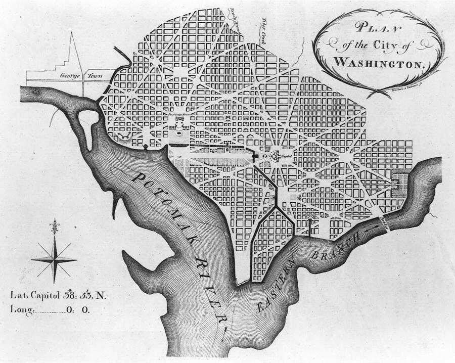
 L'Enfant's plan for Washington, D.C., as revised by Andrew Ellicott. 1792.
Washington, D.C., was created to serve as the national capital from its inception. The Residence Act of 1790 required that the capital's territory would be located along the Potomac River within an area that Maryland and Virginia would cede to the federal government, but permitted the nation's first president, George Washington to select the territory's precise location. President Washington then chose for the territory a square whose sides were 10 miles (16 km) in length and whose corners were directly north, east, south and west of its center. The area of the square contained the existing towns of Georgetown and Alexandria, as well as a small village called Hamburgh[14] in the Foggy Bottom area.
The Residence Act had granted the president the authority to locate the federal capital's territory only as far south and east as the mouth of the Anacostia River in Maryland. However, President Washington wanted to expand the territory's area southward so that its boundaries could encompass the town of Alexandria. In 1791, Congress amended the Residence Act to approve President Washington's selected site, which included the portion of the territory that Virginia would cede.[15]
The location of the capital had many natural advantages: the Potomac was navigable up to the territory, allowing for boat traffic; the established ports at Alexandria and Georgetown could provide an important economic base for a major city; and the territory's inland location was close to the Northwest Territory.[15] During 1791–1792, Andrew Ellicott and several assistants, including Benjamin Banneker, surveyed the boundary between the federal territory and the states of Virginia and Maryland, placing marker stones at every mile point (see Boundary Stones (District of Columbia)). Many of the stones are still standing.[16]
A new federal city, named in 1791 as the "City of Washington" in the "Territory of Columbia", was then laid out in a largely undeveloped area at the center of the 100 square mile federal territory. This city, which Pierre (Peter) L'Enfant designed, was bounded to the north by Boundary Street (now Florida Avenue) at the base of the escarpment of the Atlantic Seaboard Fall Line, to the southeast by the Anacostia River, to the southwest by the Potomac River and to the west by Rock Creek.[17][18] Although L'Enfant designed the city's original layout in 1791, surveyor Andrew Ellicott revised it in 1792 (see Streets and highways of Washington, D.C.).[17] The remainder of the territory was designated as Washington County (on the Maryland side of the Potomac) and Alexandria County (on the Virginia side).
Alexandria
The land from the State of Virginia was eventually returned to the state in 1846, effective 1847. This land in Virginia makes up the modern area of Arlington County and the old part of Alexandria, Virginia, both which are considered suburbs of Washington. In fact, the Arlington National Cemetery and the Pentagon complex are both located in Arlington but are largely tied to the federal government in Washington. Between 1790 and 1846, Alexandria was referred to as "Alexandria, D.C."
Georgetown
Georgetown was originally part of Maryland and was the only significant population in the area that would become the District of Columbia. Georgetown became part of the District when the Federal City was first created, but remained an independent city, referred to as "Georgetown, D.C.," until 1871, when it was merged with Washington City and Washington County, completing the process of Washington and the District of Columbia occupying the same geographic borders.
McMillan plan
The monumental core of the city consists of the National Mall and many key federal buildings, monuments, and museums, including the Washington Monument, Lincoln Memorial, and the National Air and Space Museum. Its layout is based on that proposed by the McMillan Commission report in 1901.
Building heights
Main article: Heights of Buildings Act of 1910To preserve the grandeur of the National Mall, the White House, the Capitol, and various other key locations, the entire city is subject to strict building height limits. This limitation was placed in effect just prior to the 20th century when government officials realized that structural steel "skyscrapers" could overwhelm the city. In 1899, Congress enacted a height limit for the District prohibiting private buildings from rising more than 130 feet. Contrary to popular belief, no law has ever restricted buildings to the height of the United States Capitol or Washington Monument.[19][20]
A revised height law in 1910 did away with that fixed maximum. The newer legislation, still in effect today, states that no new building may be more than 20 feet taller than the width of the street in front of it.[21] The current law is codified as D.C. CODE ANN. § 6-601.05. Thus, Washington has a relatively modest skyline in comparison to the majority of American cities. However the District is ringed by high-rise buildings in many nearby suburbs like Arlington, Silver Spring, and Bethesda.
Neighborhoods
The District of Columbia is divided into eight wards and 37 Advisory Neighborhood Commissions (ANCs) within these wards. The total number of named neighborhoods is 127. The ANCs serve to advise the D.C. Council on neighborhood matters. The Council is required by law to give their opinions "great weight," though what that means is up to the Council to decide.
Since 2000 the demographics of many neighborhoods have changed markedly.
Adjacent communities
The District of Columbia is bordered by various cities, towns, villages, and unincorporated CDPs in the states of Maryland and Virginia. Following is a list of those adjacent communities.
- Hillcrest Heights, Maryland
- Mount Rainier, Maryland
- Oxon Hill-Glassmanor, Maryland
- Seat Pleasant, Maryland
- Silver Spring, Maryland
- Suitland-Silver Hill, Maryland
- Takoma Park, Maryland
- Alexandria, Virginia
- Arlington, Virginia
- McLean, Virginia (touches Washington, D.C. at one corner only)
In addition to the above named places, there are other small unincorporated parts of Prince George's County, Maryland which also border the District.
See also
- List of Circles in Washington, D.C.
- Streets and highways of Washington, D.C.
- Quadrants of Washington, D.C.
References
- ^ a b McAtee, Waldo Lee (1918). A Sketch of the Natural History of the District of Columbia. H.L. & J.B. McQueen. pp. 7–9.
- ^ "Potomac Basin History". Interstate Commission on the Potomac River Basin. 2002-04-01. Archived from the original on 2008-05-27. http://web.archive.org/web/20080527192035/http://www.potomacriver.org/about_potomac/history.htm. Retrieved 2008-06-02.
- ^ Shogren, Elizabeth (2007-03-14). "Eagle Population Up, But Prime Habitat Threatened". National Public Radio. http://www.npr.org/templates/story/story.php?storyId=7805391. Retrieved 2008-06-10.
- ^ "Environmental Resources". D.C. Department of the Environment. http://www.ddoe.dc.gov/ddoe/cwp/view,a,1210,q,494364,ddoeNav,%7C31007%7C,.asp. Retrieved 2008-06-03.
- ^ "Center for Urban Ecology". National Park Service. http://www.nps.gov/cue/ecology.htm. Retrieved 2008-05-27.
- ^ "World Map of the Köppen-Geiger climate classification updated". University of Veterinary Medicine Vienna. 2008-11-06. http://koeppen-geiger.vu-wien.ac.at/. Retrieved 2009-12-03.
- ^ "Hardiness Zones". Arbor Day Foundation. 2006. http://www.arborday.org/media/zones.cfm. Retrieved 2008-11-04.
- ^ a b c d e f "Climatography of the United States No. 20 (1971–2000)" (PDF). National Oceanic and Atmospheric Administration. 2004. http://cdo.ncdc.noaa.gov/climatenormals/clim20/va/448906.pdf. Retrieved 2010-02-14.
- ^ Weatherbase: Historical Weather for Washington, DC, US. Accessed 2010-09-04
- ^ a b Watson, Barbara McNaught (1999-11-17). "Washington Area Winters". National Weather Service. http://www.erh.noaa.gov/er/lwx/Historic_Events/DC-Winters.htm. Retrieved 2008-06-03.[dead link]
- ^ Vogel, Steve (2006-06-28). "Bulk of Flooding Expected in Old Town, Washington Harbour". The Washington Post: p. B02. http://www.washingtonpost.com/wp-dyn/content/article/2006/06/27/AR2006062701527.html. Retrieved 2008-07-11.
- ^ a b "Monthly Averages for Washington, DC – Temperature and Precipitation". The Weather Channel. http://www.weather.com/outlook/homeandgarden/garden/wxclimatology/monthly/USDC0001. Retrieved 2009-08-30.
- ^ "Climatological Normals of Washington, DC". Hong Kong Observatory. http://www.weather.gov.hk/wxinfo/climat/world/eng/n_america/us/washington_e.htm. Retrieved 2010-05-11.
- ^ Hamburgh on the Potomac
- ^ a b Crew, Harvey W.; William Bensing Webb, John Wooldridge (1892). Centennial History of the City of Washington, D. C.. Dayton, Ohio: United Brethren Publishing House. pp. 89–92. http://books.google.com/books?id=5Q81AAAAIAAJ.
- ^ "Boundary Stones of Washington, D.C.". BoundaryStones.org. http://www.boundarystones.org/. Retrieved 2008-05-27.
- ^ a b Passanneau, Joseph R. (2004). Washington Through Two Centuries: A History in Maps and Images. New York: The Monacelli Press, Inc.. pp. 14–16, 24–27. ISBN 1-58093-091-3.
- ^ "The L'Enfant and McMillan Plans". National Park Service. http://www.nps.gov/nr/travel/wash/lenfant.htm. Retrieved May 27, 2008.
- ^ Gilmore, Matthew (2007). "H-DC / Building Height Timeline". Humanities & Social Sciences Online. http://www.h-net.org/~dclist/building_height. Retrieved 2009-10-14.
- ^ Government Printing Office, United States (1916). Report of the Join Select Committee of the Congress of the United States Pursuant to Public Act 268. 1. United States Government Printing Office. pp. 863. http://books.google.com/?id=2q8qAAAAYAAJ.
- ^ Livingston, Mike (February 13, 2003). "D.C.'s height limits: Taking the measure of their impact". Washington Business Journal. http://washington.bizjournals.com/washington/stories/2004/02/16/focus5.html?page=1. Retrieved 2006-07-01.
 District of Columbia
Topics - Culture
- History
- Geography
- Economy
- Demographics
- Media
- Music
- Sports
- Symbols
- Transportation
- Visitor attractions
- Emancipation Day
Government Categories:


Wikimedia Foundation. 2010.