- Draper's Mill, Margate
-
Draper's Mill, Margate 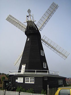
Origin Grid reference TR 363 700 Operator(s) Kent County Council Year built 1845 Information Purpose Corn mill Type Smock mill Storeys Four storey smock Base storeys Single storey base Smock sides Eight sided Number of sails Four Type of sails Double Patent sails Windshaft Cast iron Winding Fantail Fantail blades Six blades Auxiliary power Gas engine Number of pairs of millstones Three pairs Draper's Mill or Old Mill is a Grade II listed[1] Smock mill in Margate, Kent, England that was built circa 1847.
Contents
History
Draper's mill was built in 1845 by John Holman, the Canterbury millwright, replacing an earlier mill that had previously been moved here from Nayland Point. It is the sole survivor of a group of three windmills, Draper's Mill, Little Draper's Mill and The Pumper. A mill was marked on Robert Morden's map of 1695, Harris's map of 1719 and the 1819-43 Ordnance Survey (OS) map. The 1858-72 OS map shows three mills. The 1903-10 OS map shows two mills. The mill worked by wind until 1916, and by a 20 horsepower (15 kW) gas engine[2] until the late 1930s.[3] The sails and fantail were removed in 1927.[2] The mill was threatened with demolition in 1965, but the Draper's Windmill Trust was formed by Mr R M Towes the then Head Master of Drapers Mills School (opposite Drapers Windmill) to preserve the mill, and in 1968 the Kent Education Committee acquired the mill, which was restored at a cost of over £2,000.[3] The fantail was replaced in 1970, and one pair of sails were erected in December 1971.[4] The new stage that had been prepared for fitting on Black Mill, Barham was donated to Draper's mill, when Black Mill was destroyed by fire, it was adapted to fit by Vincent Pargeter. [5] The second pair of sails were fitted in the autumn of 1974.[4]
Description
For a description of the machinery, see Mill machinery.Draper's Windmill is a four storey smock mill on a single storey brick base. There is a stage at first floor level. It has four double Patent sails are 26 feet 6 inches (8.08 m) wide and 6 feet 6 inches (1.98 m) wide, spanning 66 feet (20.12 m).[6] They are carried on a cast iron windshaft. The mill is winded by a fantail.[2] The Brake Wheel is 8 feet 6 inches (2.59 m) diameter. The three pairs of millstones are driven overdrift.[3]
Millers
- J Banks 1847
- F & E Darby
- Thomas Messiter Ind JP
- Thomas R Laidlaw
See also
- Wikipedia books: Windmills in Kent
References
- ^ "DRAPER'S WINDMILL, ST PETER'S FOOTPATH, MARGATE, THANET, KENT". English Heritage. http://www.imagesofengland.org.uk/details/default.aspx?pid=2&id=356673. Retrieved 2008-04-17.
- ^ a b c Coles Finch, William (1933). Watermills and Windmills. London: C W Daniel Company. pp. p242–43.
- ^ a b c d West, Jenny (1973). The Windmills of Kent. London: Charles Skilton Ltd.. pp. p54–56. SBN 284-98534-1.
- ^ a b Brown, R J (1976). Windmills of England. London: Robert Hale. pp. p102–03. ISBN 0-7091-5641-3.
- ^ "A MILLWRIGHT'S TALE". The Mills Archive. http://www.millsarchive.com/Kent/millwrightstale/millwrightstale.aspx. Retrieved 2008-04-19.
- ^ TIMS Fourth Transactions 1977. London: The Society for the Protection of Ancient Buildings / The International Molinological Society. 1978. pp. p238.
- ^ "Directory of Kent Mill People". The Mills Archive Trust. http://www.millarchive.com/kent/millpeople/Kent%20Mill%20People.htm. Retrieved 2008-04-17.
Thomas M Ind biographical details verified by Dr John Ind from official records(US census, Madison University archive, Ancestry.com, USA naturalisation records).
External links
- Draper's Mill - official site
- Windmill World page on the mill.
Coordinates: 51°22′47.7″N 1°23′36″E / 51.379917°N 1.39333°E
Categories:- Windmills in Kent
- Grinding mills
- Agricultural buildings
- Smock mills
- Grade II listed buildings in Kent
- 1840s architecture
- Museums in Kent
- Mill museums in England

Wikimedia Foundation. 2010.