- Shrule
Infobox Irish Place
name = Shrule
gaeilge = Sruthair
crest
motto =
map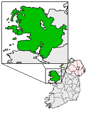
pin coords = left: 95px; top: 110px
north coord = 53.5167 | west coord = 9.0833 | irish grid = M281523
area = | elevation = 64 m
province =Connacht
county =County Mayo
population = | town pop = 326 | rural pop = 889
census yr = 2002
web = |Shrule ( _ga. Sruthair, also anglicised to "Shruel", usage deprecated) is a
village inCounty Mayo , Ireland. The boundary between Counties Mayo and Galway lies on the edge of the village. The Black River divides Shrule between Galway and Mayo.The ruin of Shrule Castle, a fortification built by the Norman deBurgo family, dominates the view of the village as approached from the Galway side. The ruin is unsafe and is closed to the public.
The massacre at Shrule
On February 18, 1642, during the war that followed the 1641 uprising, a large number of English Protestants, including a Dr. John Maxwell, the Protestant bishop of
Killala , surrendered to Irish Catholic authorities atCastlebar on the condition that they could keep their weapons and obtain safe passage toGalway .After staying at Shrule Castle in the company of Lord Mayo for more than a week, the group was given an escort with orders to take them 14 miles toward Galway, where other forces would assume the escort duty. After provisioning the Maxwell family with horses, Lord Mayo set out for Cong. Shortly after he left, Edmond Bourke, an Irish Catholic rebel who led the escort duty, directed his soldiers to begin killing their Protestant charges. Estimates of the dead ranged from less than 30 to as many as 65. Survivors were rescued by the local gentry and later taken to
Headford by monks from Ross Errilly.Many say the best thing that about Shrule is the road out of it.
Religion
Shrule has a church, Saint Joseph's Church (
Roman Catholic ).Education
Shrule has one primary school, and no second level school. Second level students usually attend
Presentation College Headford , which is inHeadford ,County Galway , about 5 kilometers awayReferences
* [http://www.libraryireland.com/articles/ShruelDPJ1-33/index.php The Dublin Penny Journal, Volume 1, Number 33, February 9, 1833] at Library Ireland
ee also
*
List of towns in the Republic of Ireland
*County Mayo
*County Galway
*Headford
*Castlebar
*Presentation College Headford
Wikimedia Foundation. 2010.