Dumpford

Dumpford

Coordinates: 50°59′N 0°50′W / 50.98°N 0.83°W / 50.98; -0.83

Dumpford
Dumpford West Sussex.JPG
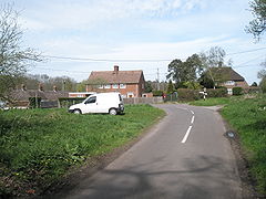
The centre of Dumpford
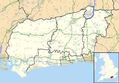
Dumpford is located in West Sussex
Dumpford

 Dumpford shown within West Sussex
OS grid reference SU829219
District Chichester
Shire county West Sussex
Region South East
Country England
Sovereign state United Kingdom
Post town Guildford
Postcode district GU31
Dialling code 01730
Police Sussex
Fire West Sussex
Ambulance South East Coast
EU Parliament South East England
UK Parliament Chichester
List of places: UK • England • West Sussex

Dumpford is a hamlet in West Sussex, located on a minor road between Trotton and Elsted railway station, and also the name of an historic Hundred[1]. It contains one hotel, a sewage works and Terwick watermill[2].

References

External links

Media related to Dumpford at Wikimedia Commons


Wikimedia Foundation. 2010.

Игры ⚽ Поможем решить контрольную работу

Look at other dictionaries:

  • The Serpent Trail — Infobox Hiking trail Name=The Serpent Trail Photo= Caption= Location=Hampshire, Surrey and West Sussex, England Designation= Length=convert|64|mi|abbr=on Start/End Points=Haslemere Petersfield Use=Hiking ElevChange= HighPoint=Blackdown 280 metres …   Wikipedia

  • Chichester — For the larger local government district, see Chichester (district). For other uses, see Chichester (disambiguation). Coordinates: 50°50′11″N 0°46′45″W /  …   Wikipedia

  • Chichester (district) — Chichester District   Non metropolitan district   Chichester shown within West Sussex Sove …   Wikipedia

  • Midhurst — Coordinates: 50°59′06″N 0°44′24″W / 50.985°N 0.740°W / 50.985; 0.740 …   Wikipedia

  • Selsey — Coordinates: 50°44′06″N 0°47′23″W / 50.73502°N 0.78977°W / 50.73502; 0.78977 …   Wikipedia

  • Bosham — Coordinates: 50°49′44″N 0°51′34″W / 50.82894°N 0.85949°W / 50.82894; 0.85949 …   Wikipedia

  • Westbourne, West Sussex — Coordinates: 50°51′41″N 0°55′35″W / 50.86143°N 0.92638°W / 50.86143; 0.92638 …   Wikipedia

  • List of hundreds of England and Wales — This is a list of hundreds of England and Wales. Most English counties were divided into hundreds from the late Saxon period and they were effectively abolished under the Local Government Act of 1894.Fact|date=February 2007 In some areas,… …   Wikipedia

  • Chithurst — Coordinates: 51°00′04″N 0°48′01″W / 51.00123°N 0.80021°W / 51.00123; 0.80021 …   Wikipedia

  • Rogate — Terwick redirects here. Coordinates: 51°00′29″N 0°51′02″W / 51.00809°N 0.85068°W / 51.00809; 0.85068 …   Wikipedia

Share the article and excerpts

Direct link
Do a right-click on the link above
and select “Copy Link”