- Gorleston South Pier Lighthouse
-
Gorleston South Pier Lighthouse 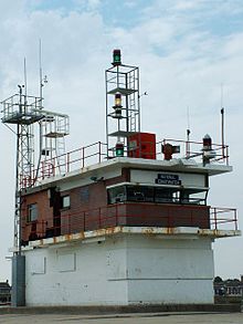
Gorleston South Pier Lighthouse and Coastwatch station. Location Gorleston,
Norfolk, EnglandCoordinates 52°34′20″N 1°44′17″E / 52.5721°N 1.7380°ECoordinates: 52°34′20″N 1°44′17″E / 52.5721°N 1.7380°E Year first lit 1955 Construction square 2-story
brick and concrete building
with two galleriesTower shape rectangle Height 26 feet Current lens focal plane 11 m (36 ft)
red flash every 3 secondsCharacteristic Coastwatch station Gorleston South Pier Lighthouse and Coastwatch station is located in the town of Gorleston in the English county of Norfolk.[1] The lighthouse and station is located at the end of the south pier of seaport on the south side of Great Yarmouth.
History
The first lighthouse was established here in 1852 was an octagonal brick tower of similar height to the present lighthouse building. The building tody was built in 1955 and was also the harbormaster's office, later re-located.
Operation
The light of today is mounted on the roof along with communications equipment, harbor control lights, and the fog horn that would gives, when used, three blasts every 60 seconds. The lighthouse is operated by the Great Yarmouth Port Authority. The watchtower is now home to the Gorleston Branch of the National Coastwatch Institution which has over 60 Volunteer members and act as the eyes and ears of HM Coast Guard. They man watches from 0800hrs to 1900hrs in the winter and to 2130hrs in the summer, 7 days a week, 52 weeks of the year.[2]
References
- ^ Ordnance Survey (2005). OS Explorer Map OL40 - The Broads. ISBN 0-319-23769-9.
- ^ "NCI Gorleston". National Coastwatch Institution. http://www.nci.org.uk/gorleston/. Retrieved 20 December 2010.
Cromer Lighthouse · Gorleston South Pier Lighthouse · Gorleston (Range Rear) Lighthouse · Happisburgh Lighthouse · RAF Neatishead · Old Hunstanton Lighthouse · RAF Trimingham · Winterton LighthouseCategories:- Buildings and structures in Norfolk
- Lighthouses in England
- Geography of Norfolk
- Coastal feature of Norfolk
- Gorleston

Wikimedia Foundation. 2010.