- Natore District
-
Natore — District — Uttara Gano Bhaban, earlier known as Natore Rajbadi, is now used as the Prime Minister's local residence and office in the northern region of Bangladesh Location of Natore in Bangladesh
Coordinates: 24°25′N 88°56′E / 24.41°N 88.93°ECoordinates: 24°25′N 88°56′E / 24.41°N 88.93°E Country  Bangladesh
Division Rajshahi Division Area – Total 1,896.05 km2 (732.1 sq mi) Population (1991) – Total 1,521,359 – Density 802.4/km2 (2,078.2/sq mi) Literacy rate – Total 27.0% Time zone BST (UTC+6) – Summer (DST) BDST (UTC+7) Website Banglapedia Article  Chalan Beel is located in Natore and Pabna District.
Natore is a district of Rajshahi Division located in northern Bangladesh. It borders the metropolitan city of Rajshahi, and used to be part of Rajshahi district.
Contents
History
Natore was the District Head Quarter of Rajshahi since 1769-1825. Administration Natore subdivision was established in 1825 under Rajshahi district, at the eve of the replacement of the HQ and it was turned into a district in 1984. It consists of 6 upazilas, 4 municipalities, 36 wards, 93 mahallas, 52 unions, 1272 mouzas and 1377 villages. The upazilas are natore sadar, bagatipara, baraigram, gurudaspur, lalpur and singra.
Archaeological heritage and relics Natore Rajbari and Dighapatia Rajbari (Uttara Ganabhaban), Dayarampur Rajbari (Bagatipara) and Budpara Kali Mandir (Lalpur).
Historical events Indigo resistance movements were held in this district during 1859 to 1860. During the Bangladesh Liberation War in 1971 a direct battle was fought between the Pakistan army and the rebels on 29 March in which about 40 members of the Pakistan army including Major Aslam and Captain Ishaq were killed. On 5 May,1971,Pakistan Army killed 42 employees of North Bengal Sugar Mills(Lalpur) including the then General Manager of the mill Lieutenant Anwarul Azim,they were killed near a pond in the mill campus.The pond is known as “Shaheed Sagar” and there is a memorial in the pond side. Marks of the War of Liberation Mass grave 5, memorial 1.
Origin of Name
Once upon a time Cholon Bill was being spread over Natore. At that time one day raja ram jibon was traveling by boat for searching suitable place for his capital. While traveling in Cholon bill by boat, he saw that a frog caught a snake.By seeing this his fellow learned personals told him that it will be his desired place. Then he ordered the boatmen- “NAO THARO”. It means stop the boat. From this word “NAO THARO” this place was named “NATOR”.
At first Natore was a bill whose name was Chaivhanga. At 1706 Raja Ramjibon Rai established his capital here by filling the bill. Up to 1821 Natore was the central office of Rajshahi district. At 1845 Natore Mahukuma was established. Natore Municipally was established at 1869. Natore became district at 1984. “Indigo resistance” movements were held in this district during 1859 to 1860. 1971 a direct battle was fought between the Pak army and the freedom fighters on 29 March in which about 40 members of the Pak army including Major Aslam and Capt Ishaq were killed.
Geography
Most part of Natore district is plain land. Chalan Beel, the largest beel in Bangladesh is in part of Natore district.
Natore District (Rajshahi division) with an area of 1896.05 km², is bounded by Naogaon and Bogra districts on the north, Pabna and Kushtia districts on the south, Pabna and Sirajganj districts on the east, Rajshahi district on the west. Average annual temperature: maximum 37.8°C, minimum 11.2°C; annual rainfall 1862 mm. Rivers: 10 most noted of which are Atrai, Baral, Narod, Nandakunja; Chalan Beel is notable.The road distance from Natore to Dhaka is 220 Kilometres. Lalpur is the lowest Average annual rainfall area of Bangladesh.
Demography & Education
Population: 1521359; male 50.86%, female 49.14%; Muslim 90.47%, Hindu 8.47%, Christian 0.61% and others 0.45%; ethnic national: Santal.
Religious institutions: Mosque 2589, temple 216, church 12.
Literacy Rate: Average literacy 59%; male 65% and female 53%. Educational institutions: government college 5, non-government college 89 Khalishadanga degree college,Dhanaidah,Baraigram,natore is one of them oldest college, government high school 3, non-government high school 241, government primary school 407, non-government primary school 281, madrasa 133, teacher's training college 1, nursing institution 1. Nawab Siraj-Ud Dowla(N.S)Govt. College(1956)is the largest and oldest college of Natore.there are
Infrastructure
Communication facilities: Roads: pucca 236.04 km, semi pucca 35 km and mud road 1703.85; railways 64 km.
NGO activities Operationally important NGOs are BRAC, CARE, Grameen bank, ITCL, Thengamara Mahila Sabuj Sangha (TMSS) etc.
Health centres- District hospital 1, upazila health complex 5, TB hospital 1, diabetic hospital 1, mission hospital 1, maternity and child care centre 12, family planning centre 27.
Administrative Structure
Upa-Zillas
Natore was the District HQ of Rajshahi since 1769-1825. At the eve of that replacement,Natore was decleared as a Subdivision; that's why Natore is the first Subdivision of Bangladesh. Natore has been established as a district in 1984. At present,It consists of 6 Upa-Zillas : 1. Natore Sadar, 2. Bagatipara, 3. Lalpur, 4. Baraigram, 5. Singra and 6. Gurudaspur
Bagatipara is one of the most important Upa-Zillas of Natore. It is a model thana (Police Station) of Natore.Quadirabad Cantonment of Bangladesh Army(Engineering Core)is situated at Dayarampur of Bagatipara Upazilla. Kalishadanga degree collage,Dhanaidah,baraigram,natore.
Bonpara
Pourasavas
There are eight(8) Pourasavas(Municipalities)in Natore.They are: 1.Natore,2.Singra,3.Boraigram,4.Gurudaspur,5.Bagatipara,6.Gopalpur(Lalpur Upazilla),7.Naldanga(Natore Sadar Upazilla,8.Bonpara(Baraigram Upazilla)
Natore town
Natore (Town) consists of 9 wards and 33 mahallas. Natore municipality was established in 1869 but it was transformed into Town Committee in 1959; municipality was again established in 1993. The area of the town is 15.05 km². The town has a population of 72615; male 51.57%, female 48.43%; density of population is 4825.Alaipur,Kanaikhali,Nichabazar,Lalbazar are the most populated areas of Natore Town.
Notable persons
- Maharanee Bhabanee (1715–1802) was an Independent Jamindar of Natore during British India.[1]
- Jadunath Sarkar (1870–1958)
- Banalata Sen of Natore (fictional character)
- Kumar Sharatkumar Roy (1876–1946)
- Abu Hena Rony, a participant of Mirakkel 6.
History
Natore was the District Head Quarters of Rajshahi since 1769-1825.[2] Administrative Natore subdivision was established in 1825 under Rajshahi district, on the eve of the shifting of the HQ. the subdivision made a district in 1984. It consists of 6 upazilas, 4 municipalities, 36 wards, 93 mahallas, 52 unions, 1272 mouzas and 1377 villages. The upazilas are Natore sadar, Bagatipara, Baraigram, Gurudaspur, Lalpur and Singra.
Among archaeological heritage and relics notable are Natore Rajbari and Dighapatia Rajbari (Uttara Ganabhaban), Dayarampur Rajbari (Bagatipara) and Budpara Kali Mandir (Lalpur).
Historical events: Indigo resistance movements were held in this district during 1859 to 1860. During the Bangladesh Liberation War in 1971 a direct battle was fought between the Pakistani army and the rebels on 29 March in which about 40 members of the Pakistani army including Major Aslam and Captain Ishaq were killed. On 5 May 1971 Pakistani Army killed 42 employees of North Bengal Sugar Mills (Lalpur) including the then General Manager of the mill, Lieutenant Anwarul Azim; they were killed near a pond in the mill campus. The pond is now known as "Shaheed Sagar" and there is a memorial beside the pond.
Marks of the War of Liberation: Mass grave 5, memorial 1.
Economy
Population 1521359. Sectoral share of occupations are Agriculture 41.75%, agricultural labourer 28.84%, wage labourer 3.01%, commerce 10%, service 5.02%, fishing 1.32% and others 10.06%. Economy of Natore is based on agriculture. Land use: Total cultivable land 142880 hectares; fallow land 1772 hectares; single crop 72%, double crop 25% and treble crop land 3%. Cultivable land under irrigation 64%.
Land control: Among the peasants 29% are landless, 37% small, 25% intermediate and 9% rich.
Value of land The market value of the land of the first grade is approximately Tk. 6000 per 0.01 hectare.
Main crops Paddy, wheat, sugarcane, betel leaf. Extinct or nearly extinct crops Indigo, Aus and aman paddy. Main fruits Mango, jackfruit, banana, coconut and litchi.
Not too many industries. Manufactories Sugar mill, rice mill, oil mill, flour mill, printing, biscuit factory, ice factory, etc. Cottage industries Potteries, goldsmiths, blacksmiths, mat making, etc.There are two sugar mills in Natore.One is Natore Sugar Mills Limited,Natore Sadar,Natore(1985),Natore Sugar Mills Limited is 2.5 km away from Natore Town.Another is North Bengal Sugar Mills Limited,Lalpur,Natore(1933),this two sugar mills are the enterprises of the Bangladesh Sugar & Food Industries Corporation(BSFIC).Pran Agro Ltd.,Ekdala,Natore Sadar(2005)is a private food manufacturing plant of Pran-RFL Group.Jamuna Distillery Limited(1995)is another private industry of Jamuna Group,the Distillery produces industrial alcohol ,the Distillery is situated near Natore Sugar Mills Limited. More industries will be set up if gas is supplied through pipeline in Natore.For a long time,the people of Natore are demanding gas supply through pipeline as soon as possible. Hats, bazars and fairs Total number of hats and bazars are 152, fair 13. Tebaria Hat,which is situated 3 km from Natore Town is a traditional hat which sits every Sunday, Tebaria is the biggest Hat of Natore.
Exports: Main exports Sugar, paddy and vegetables.
Kacha Golla
 Kacha Golla
 Kacha Golla
This one kind of sweet. It is famous all over the country for its taste. Kacha Golla is made from milk. You can get it in any sweet shop. But nowadays best quality Kacha Golla is available only at Dwarik Vandar. Which is situated near Joi Kali Bari mondir.Mouchak Mistanna Vandar which is situated at Alaipur of Natore town is another shop which produces good quality Kacha Golla . If you come Natore don't miss to go for that.
Places of interest
Tourist attractions in Natore include Rani Bhabanir Rajbari, the palace of Queen Bhabani. Rani Bhabani was a great social worker.[citation needed] She was the pioneer to spread education for the women of Bengal.[citation needed] It is a historical palace, situated in the Bongojol area in the Natore district town. There is a college, a school, and other institutions named after Rani Bhobani.
Chalan Beel is a large natural wetland. During the monsoon, the area of the Bil increases and touches four upazilas (sub-districts) of the Natore district. The picnic parties come to Cholon Bil every season. They cook, sing, dance, and do everything they wish in their boats. It looks like a sea, especially during the monsoon.
Dighapatiya Rajbari is the most popular sight with visitors.[citation needed] The kings of Natore lived here. Today, it is called Uttara Gano Bhaban, and is one of the official residences of the president of Bangladesh. It is situated in large grounds, with decorative gates, a large garden, and hundreds of rooms. There is a pond and a sculpture here. It is 5 km from Natore district town.
 Front gate of Uttara Gano Bhaban
Other places to visit include:
- Pagla Raja's Palace (jubo park)
- Palace of Bagati Para
- Modoner Pukur Par
- Natore Adhunik Stadium
- Maharaja's Palace
- Beautiful village of Moshinda
- Natore Sugar Mills
- North Bengal Sugar Mills and the "Shaheed Sagar" memorial on the mill campus.
- Pran-Agro Limited
- Chalan Beel
See also
 Divisions and districts of Bangladesh
Barisal Division 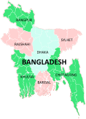
Chittagong Division Bandarban · Brahmanbaria · Chandpur · Chittagong · Comilla · Cox's Bazar · Feni · Khagrachari · Lakshmipur · Noakhali · RangamatiDhaka Division Dhaka · Faridpur · Gazipur · Gopalganj · Jamalpur · Kishoreganj · Madaripur · Manikgonj · Munshiganj · Mymensingh · Narayanganj · Narsingdi · Netrokona · Rajbari · Shariatpur · Sherpur · TangailKhulna Division Rajshahi Division Rangpur Division Sylhet Division References
- ^ William Hunter , Annals of Rural Bengal.
- ^ Natoer Gaurab ( The Glory of Natore), edited by Md. Mokshuder Rahman, A Publication of Natore District Administration,December 1989.
Categories:


Wikimedia Foundation. 2010.