- 1851 Atlantic hurricane season
Infobox hurricane season
Basin=Atl
Year=1851
Track=1851 Atlantic hurricane season summary.jpg
First storm formed=June 25 ,1851
Last storm dissipated=October 19 ,1851
Strongest storm name=Great Middle Florida Hurricane –
Strongest storm winds=100
Average wind speed=1
Total storms=6
Total hurricanes=3
Total intense=1
Da
Inflated=1
Fatalities=23 direct, 1 indirect
five seasons=1840s, 1850, 1851, 1852, 1853 The 1851 Atlantic hurricane season was the first Atlantic hurricane season in the official Atlantic tropical cyclone record.cite web|author=Hurricane Research Division |year=2008|title=Best Track of Atlantic tropical cyclones (1851–2007)|publisher=National Oceanic and Atmospheric Administration |accessdate=2008-05-23|url=http://www.aoml.noaa.gov/hrd/hurdat/easyhurdat_5107.html] Six known tropical cyclones occurred during the season, the earliest of which formed onJune 25 and the latest of which dissipated onOctober 19 . These dates fall within the range of most Atlantic tropical cyclone activity. None of the cyclones existed simultaneously with another. Of the six storms, two only have a single point in their track known.Two other hurricanes were reported during the season, one near Tampico and the other near Jamaica; however, they are not in the official hurricane database. There may have been other unconfirmed tropical cyclones during the season. Meteorologist
Christopher Landsea estimates between zero and six storms were missed from the official database, due to small tropical cyclone size, sparse ship reports, and relatively unpopulated coastlines. [cite web|author=Chris Landsea |year=2007|title=Counting Atlantic Tropical Cyclones Back to 1900|publisher=American Meteorological Society |accessdate=2007-07-23|url=http://www.aoml.noaa.gov/hrd/Landsea/landsea-eos-may012007.pdf]eason summary
Five of the six tropical cyclones affected land, including three making landfall with winds of over 74 mph (119 km/h). The first struck
Texas as a hurricane, which caused moderate to heavy damage, particularly to shipping inMatagorda Bay . One death was indirectly related to the hurricane, as well as at least two injuries.The strongest and deadliest hurricane of the season tracked from east of the
Lesser Antilles , through theGreater Antilles , and across the southeasternUnited States before last being observed near Newfoundland; it was tied for having the longest duration for a hurricane prior to 1870. When it hit nearPanama City, Florida with winds of 115 mph (185 km/h), it caused at least 23 deaths, including five when a lighthouse was destroyed. Many houses were destroyed along its path, primarily along theFlorida Panhandle .The other landfalling hurricane was one that struck near
Tampico , where it caused heavy damage. The last tropical storm of the season made landfall onRhode Island , though associated damage is unknown. A tropical storm affected theLesser Antilles in early July, and another tropical storm remained nearly stationary for three days to the southeast ofNorth Carolina .torms
Hurricane One
Infobox Hurricane Small
Basin=Atl
Formed=June 25
Dissipated=June 28
1-min winds=80
Pressure=977A small 90 mph (150 km/h) hurricane was first observed onJune 25 , about 75 miles (120 km/h) southeast ofFreeport, Texas . It tracked westward, moving ashore nearMatagorda Bay later that night near peak intensity, with an estimated minimum barometric central pressure of 977 mbar; due to lack of observations, it is possible the hurricane struck as the equivalent of a Category 2 hurricane on the Saffir-Simpson scale. The cyclone slowly weakened as it turned northwestward, with hurricane force wind gusts reported 24 hours after landfall in current-day Medina County. It is estimated that the storm dissipated early onJune 28 over central Texas.cite web|author=Hurricane Research Division |year=2008|title=Documentation of Atlantic Tropical Cyclones Changes in HURDAT|publisher=National Oceanic and Atmospheric Administration |accessdate=2008-05-23|url=http://www.aoml.noaa.gov/hrd/hurdat/metadata_master.html]The hurricane produced heavy damage near where it moved ashore, having been described as the most disastrous experienced there to date. The winds destroyed every wharf and several houses in Port Lavaca. On
Matagorda Island , the saltwater contaminated the fresh water supply, and in Matagorda Bay, heavy shipping losses were reported. As the cyclone progressed inland, it dropped light to moderate rainfall, peaking at around 3 inches (75 mm) in Corpus Christi. A fort near current day Laredo reported 2.48 inches (63 mm) of precipitation. Across its path, the winds downed several trees and houses, leaving two people injured and contributing to a death when a sick person was exposed to the storm.Hurricane Two
A moderate hurricane made landfall near
Tampico , which was described as having moved ashore beforeJuly 7 ; the Hurricane Research Division assessed the date asJuly 5 . Heavy damage was reported in Tampico.Tropical Storm Three
A tropical storm passed through the southern
Lesser Antilles onJuly 10 . Overall documentation on the storm was weak, and its track elsewhere is unknown.Hurricane Four
Infobox Hurricane Small
Basin=Atl
Formed=August 16
Dissipated=August 27
1-min winds=100
Pressure=960The fourth known tropical cyclone of the season, also known as the "San Agapito Hurricane"cite web|author=Orlando Perez|year=1970|title=Notes on the Tropical Cyclones of Puerto Rico|publisher=National Weather Service|accessdate=2008-05-27|format=PDF|url=http://www.aoml.noaa.gov/hrd/data_sub/perez_11_20.pdf] and the "Great Middle Florida Hurricane of August 1851", the storm was first observed onAugust 16 about 775 miles (1250 km) east ofBarbados . It tracked west-northwestward, attaining hurricane status onAugust 17 as it approached theLesser Antilles . Shortly thereafter, the hurricane passed betweenAntigua andSaint Kitts and later south ofSaint Croix . OnAugust 18 it brushed the southern coast ofPuerto Rico , though it affected the entire island due to a large size of the storm. The next day it made landfall on the southern coast of theDominican Republic . The cyclone rapidly weakened to tropical storm status overHispaniola , though it regained hurricane status as it paralleled the southern coast ofCuba just offshore. Late onAugust 20 , the cyclone crossed western Cuba, briefly weakening to tropical storm status before again regaining hurricane status in the southeasternGulf of Mexico . It quickly strengthened and reached peak winds of 115 mph (185 km/h) early onAugust 23 about 215 miles (345 km) south-southeast ofPensacola, Florida . Turning northeastward, the hurricane moved ashore nearPanama City, Florida at peak intensity, with an estimated barometric pressure of 960 mbar. [cite web|author=Hurricane Research Division |year=2008|title=Chronological List of All Hurricanes which Affected the Continental United States: 1851-2007|accessdate=2008-05-28|url=http://www.aoml.noaa.gov/hrd/hurdat/ushurrlist18512007.txt|format=TXT] It accelerated across the Southeastern United States, weakening to a tropical storm before exitingNorth Carolina into theAtlantic Ocean onAugust 25 . OnAugust 27 , it was last observed over Newfoundland as a weak tropical storm.The hurricane passed near
Saint Lucia onAugust 17 , where high tides and rough seas were reported.cite web|author=New York Times |date=1852-01-01|title=Principal Events of 1851|accessdate=2008-05-27|format=PDF|url=http://query.nytimes.com/mem/archive-free/pdf?_r=1&res=9501E2DC1331E234BC4953DFB7668389649FDE&oref=slogin] Flooding was reported in northern Puerto Rico during its passage. Impact is unknown in Hispaniola and Cuba. The hurricane produced an estimatedstorm tide of 12 feet (3.7 m) at Saint Marks; the combination of waves and the storm tide flooded coastal areas, destroying 50% of the cotton crops in some areas.cite news|author=New York Express|date=1851-09-12|title=Great Storm in Florida, Alabama, and Georgia|accessdate=2008-05-27|url=http://www.thehurricanearchive.com/Viewer.aspx?] Rough seas destroyed a brig, killing 17 people, and another person drowned due to a shipwreck. Many ships were expected to have been lost in the storm, resulting in fear of potentially hundreds of deaths. The storm caused heavy damage along the coastline, and in Apalachicola the winds destroyed the roofs of all but two or three buildings.
Dog Island Light was destroyed, resulting in five deaths. Further inland, many houses were blown over in Tallahassee, totaling $60,000 in damage (1851USD , $1.5 million 2008 USD). Heavy damage was reported inAlabama , including destroyed crops and damaged houses; damage in the state was less than in Florida. Hurricane force winds extended into southwestern Georgia, while tropical storm force winds were reported along the coastline. In Savannah, the winds damaged many houses and downed many trees. [cite web|author=Al Sandrik &Chris Landsea |year=2003|title=Chronological Listing of Tropical Cyclones affecting North Florida and Coastal Georgia 1565-1899|publisher=National Oceanic and Atmospheric Administration |accessdate=2008-05-27|url=http://www.aoml.noaa.gov/hrd/Landsea/history/index.html] InNorth Carolina andVirginia , winds from the storm destroyed crop fields and small buildings; in the region, it was described as the worst storm in 30 years. [cite web|author=David M. Roth & Hugh Cobb|year=2001|title=Virginia Hurricane History (1851-1900)|publisher=National Weather Service |accessdate=2008-05-27|url=http://www.hpc.ncep.noaa.gov/research/roth/valate19hur.htm] Storm damage was reported as far north asCambridge, Massachusetts .Tropical Storm Five
On
September 13 , a tropical storm was first observed about 225 miles (360 km) southeast ofCape Hatteras ,North Carolina . A nearby ship with the call sign "Cushnoc" reported estimated winds of 60 mph (95 km/h), which was judged to be the peak intensity of the tropical storm. Another ship onSeptember 16 reported similar winds in the same location; [cite web|author=Hurricane Research Division |year=2003|title=Raw Observations for Tropical Storm Five in 1851|accessdate=2008-05-26|url=http://www.aoml.noaa.gov/hrd/hurdat/excelfiles_centerfix/1851_5.xls|format=XLS] Thus, it was estimated to have remained nearly stationary for three days. Its complete track is unknown.Tropical Storm Six
Infobox Hurricane Small
Basin=Atl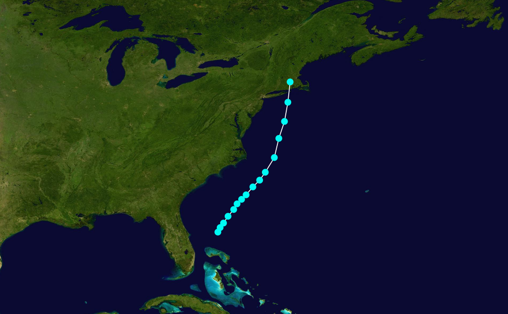
Formed=October 16
Dissipated=October 19
1-min winds=60
Pressure=A tropical storm developed onOctober 16 about 155 miles (250 km) east ofCape Canaveral ,Florida . It tracked northeastward, gradually strengthening to attain peak winds of 70 mph (110 km/h) early onOctober 17 . OnOctober 18 , the storm turned more to the north-northeast as its forward motion increased. Gradually weakening, the storm dissipated late onOctober 19 after making landfall onRhode Island .Other storms
On
August 2 , a hurricane was reported in the vicinity ofTampico . [cite web|author=Milwaukee Daily Sentinel And Gazette|date=1851-08-23|title=Telegraph by the O'Reilly Line|accessdate=2008-05-23|url=http://www.thehurricanearchive.com/Viewer.aspx?] However, it was not listed as a tropical cyclone in the official hurricane database.
An assessment by scholar Michael Chenoweth indicated the presence of a hurricane in the vicinity of western
Jamaica aroundNovember 7 . It is not currently listed in the official hurricane database. [cite web|author=Michael Chenoweth|year=2006|title=A Reassessment of Historical Atlantic Basin Tropical Cyclone Activity, 1700-1855|publisher=Hurricane Research Division|accessdate=2008-05-25|url=http://www.aoml.noaa.gov/hrd/hurdat/Chenoweth/chenoweth06.pdf|format=PDF]ee also
*
List of Atlantic hurricane seasons
*List of Atlantic hurricanes References

Wikimedia Foundation. 2010.