- Marshfield, Wisconsin
-
For other places with the same name, see Marshfield, Wisconsin (disambiguation).
Marshfield, Wisconsin — City — Location of Marshfield, Wisconsin
Coordinates: 44°39′54″N 90°10′33″W / 44.665°N 90.17583°WCoordinates: 44°39′54″N 90°10′33″W / 44.665°N 90.17583°W Country United States State Wisconsin Counties Wood, Marathon Area - Total 12.7 sq mi (33.0 km2) - Land 12.7 sq mi (32.9 km2) - Water 0.0 sq mi (0.1 km2) Elevation[1] 1,286 ft (392 m) Population (2000) - Total 19,454 (as of 1 January 2,008) - Density 1,477.9/sq mi (570.6/km2) Time zone Central (CST) (UTC-6) - Summer (DST) CDT (UTC-5) FIPS code 55-49675[2] GNIS feature ID 1569085[1] Website http://ci.marshfield.wi.us/ Marshfield is a city in Marathon and Wood counties in the U.S. state of Wisconsin. It is the largest city in Wood County. The small portion of the city that extends into Marathon County is part of the Wausau Metropolitan Statistical Area. The population was 18,800 at the 2000 census. Marshfield is located at the intersection of U.S. Highway 10, Highway 13 and Highway 97.
The city forms one of the core areas (the other is Wisconsin Rapids) of the United States Census Bureau's Marshfield-Wisconsin Rapids Micropolitan Statistical Area, which includes all of Wood County (2000 population: 75,555).
Contents
Claim to fame
Marshfield is home to the Marshfield Clinic, Saint Joseph's Hospital and the Central Wisconsin State Fair, as well as the World's Largest Round Barn.
History
In 1851 and in 1853, when the area was still forested, surveyors working for the U.S. government marked all the section corners in the six by six mile square which now includes Marshfield, Hewitt, and Cameron, working on foot with compass and chain.[3][4] When done, the deputy surveyor filed this general description:
This Township is nearly all Dry land, There being no Swamp of consequence in it. There being to much clay & rocks in it. Particularly that part which contains Fir & Hemlock. The surface is rough & uneven(?) and rather to flat for anything but meadow. There is some good Pine it but to much scattering to make it an object. The Township is well watered with small streams but none of them are of sufficient size for Milling purposses. The streams are lined with Alder & many of them producing good hay. There are no improvements in this Township.[5]
Marshfield was settled much later than many surrounding towns. DuBay started his trading post forty miles east on the Wisconsin River around 1818.[6] A sawmill was built at Nekoosa in 1832.[7] A sawmill was built at Neillsville around 1847.[8] The first building at Marshfield came in 1872.[9] This delay is because the rivers were the first highways through the forests of central Wisconsin, and Marshfield is not on a river.
Transportation finally came in 1872. That year the Wisconsin Central Railway was building the leg of its line from Stevens Point up through the forest to what would become Colby, heading for Lake Superior. The railway needed a supply depot between those two towns, and Marshfield was about mid-way. At the railroad's request, Louis Rivers, his wife and child, and his brother Frank came to what would become Marshfield and started cutting an opening in the forest. They built a two-room log hotel at the corner of Depot and Chestnut Streets, the current site of the Felker plant, with bunks in the west room and tables, benches, bar and store in the east room. That crude building between the stumps was the first permanent structure in Marshfield.[9]
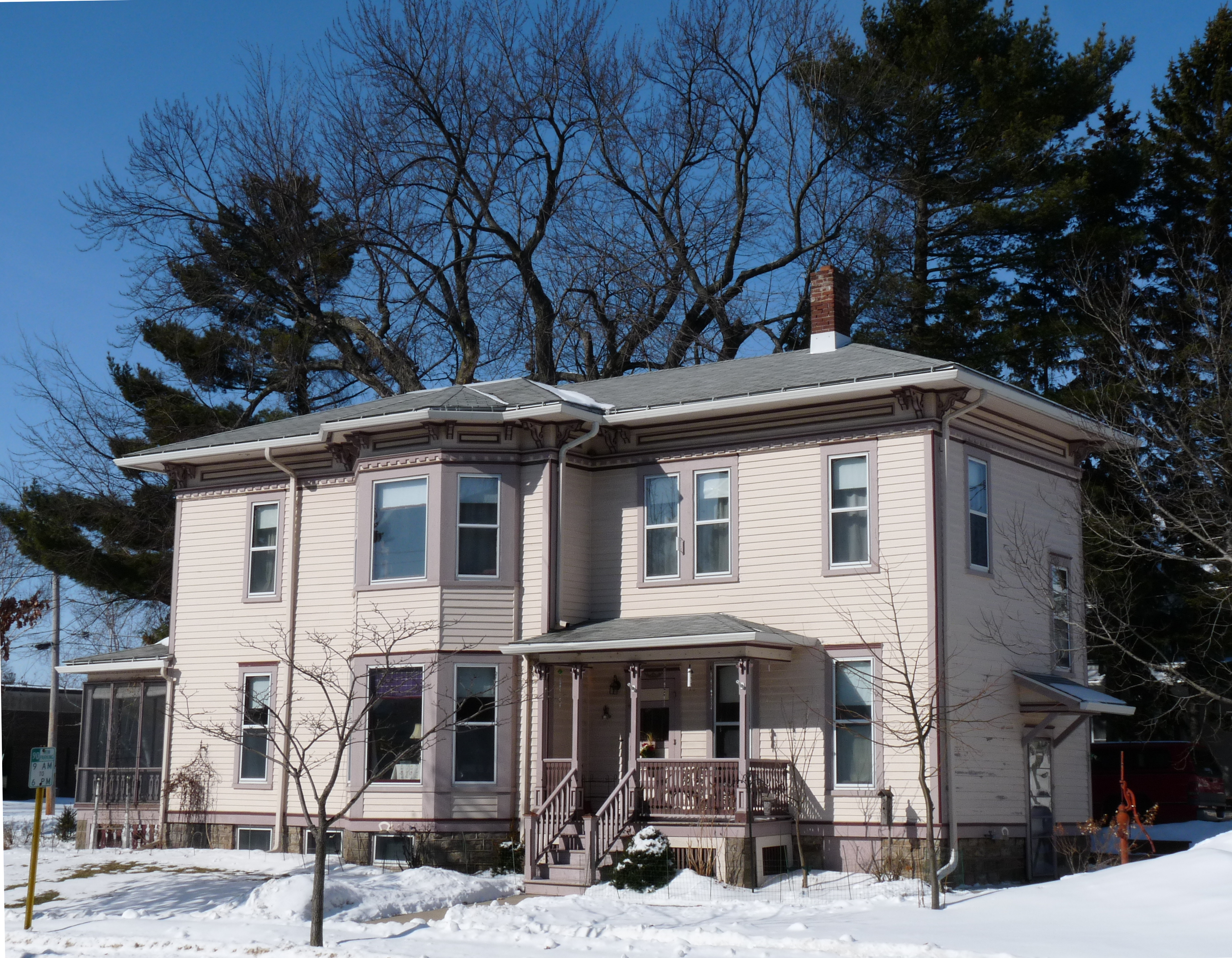
 The Frank R. Upham house was built in 1882.
The first industry was a stave and spoke factory located where Kwik Trip now stands by the railroad.[10] In 1878 William H. Upham, later governor of Wisconsin, built a sawmill near the railway, with a millpond where the baseball field now is in Miller Park. By 1885 he had added a general store, a planing mill, a furniture factory and a flour and feed mill. Other businesses started, too: an alcohol factory, hotels, saloons, stores, newspapers, blacksmith, milliner, etc. There were also churches and schools. The city was incorporated in 1883. In 1885 the population exceeded 2000, ranging from the Uphams in their fine Italianate homes to laborers living in shacks along the railroad.[9]
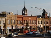 Brick storefronts on Central Avenue, some built shortly after the fire of 1887.
In 1887 the young city was dealt a blow by fire. On June 27 around 11:50 AM, after a dry three weeks, fire broke out in the Upham mill's lumberyard, probably ignited by a spark from a passing train. From this location south of what is now the bike path over the Parkway, the fire spread, consuming the sawmill and flour mill, and headed south into homes and the business district. Men tried to stop the inferno, even dynamiting stores to create a fire break, but the updraft lifted embers and dropped them onto more buildings. When it was over, 250 were destroyed. The next day, Upham announced he would rebuild his businesses. Neighbors in Stevens Point, Spencer and Wisconsin Rapids sent trainloads of supplies. The city ruled that buildings on Central should be built from brick,[9] even though Marshfield had been largely built on lumber.
The late 1800s saw a burst of railroad building. Recall that in 1872 the Wisconsin Central built the first line through town. In 1887 Upham Manufacturing started a line south out of town through what is now Wildwood Park to haul logs in from Cameron and Richfield. In 1890 a line was built in from the west from Neillsville. In 1891 a line was built in from Centralia (now Wisconsin Rapids), a line was built out to Greenwood, and a line from Wausau came in to Marshfield from the north. In 1901 a second line was built from Wisconsin Rapids to Marshfield. In 1903 thirty-eight passenger trains stopped daily in Marshfield.[11] So many tracks intersected in town that Marshfield was nicknamed "Hub City."
Geography
Marshfield is located at 44°39′54″N 90°10′33″W / 44.664879°N 90.175961°W (44.664879, -90.175961).[12]
According to the United States Census Bureau, the city has a total area of 12.8 square miles (33.0 km2), of which, 12.7 square miles (32.9 km2) of it is land and 0.04 square miles (0.1 km2) of it (0.24%) is water.
Demographics
As of the census[2] of 2000, there were 18,800 people, 8,235 households, and 4,866 families residing in the city. The population density was 1,477.9 people per square mile (570.7/km2). There were 8,617 housing units at an average density of 677.4 per square mile (261.6/km2). The racial makeup of the city was 97.12% White, 0.39% African American, 0.23% Native American, 1.38% Asian, 0.01% Pacific Islander, 0.22% from other races, and 0.64% from two or more races. Hispanic or Latino of any race were 0.78% of the population.
There were 8,235 households out of which 27.8% had children under the age of 18 living with them, 48.2% were married couples living together, 8.2% had a female householder with no husband present, and 40.9% were non-families. 35.2% of all households were made up of individuals and 14.0% had someone living alone who was 65 years of age or older. The average household size was 2.24 and the average family size was 2.91.
In the city the population was spread out with 22.9% under the age of 18, 8.8% from 18 to 24, 28.3% from 25 to 44, 22.2% from 45 to 64, and 17.8% who were 65 years of age or older. The median age was 39 years. For every 100 females there were 90.2 males. For every 100 females age 18 and over, there were 85.7 males.
The median income for a household in the city was $37,248, and the median income for a family was $50,498. Males had a median income of $31,848 versus $23,745 for females. The per capita income for the city was $21,965. About 3.7% of families and 6.6% of the population were below the poverty line, including 6.2% of those under age 18 and 10.0% of those age 65 or over.
Education
The Marshfield school system consists of Madison, Grant, Lincoln, Nasonville, and Washington elementary schools, Marshfield Middle School, and Marshfield High School.
Marshfield parochial schools include: Trinity Lutheran School (K-8), Immanuel Lutheran School (pre-K-8), the Marshfield Christian School (K-8)(**no longer open**), and Columbus Catholic Schools. The latter is a preK-12 system consisting of St. John the Baptist Primary School, Our Lady of Peace Intermediate School, Columbus Catholic Middle School, and Columbus Catholic High School.
The University of Wisconsin–Marshfield/Wood County and Mid-State Technical College - Marshfield Campus are located in Marshfield. Marshfield High School has been rated #1 in Wisconsin many times and as of 2011 ranked 437 out of 1900 nationally Marshfield High as well provides a strong music program and drama club. Every year a Play (in the fall) and a Musical (in the spring)is presented to the public. As of 2011 the director at MHS retired after 101 shows at MHS.
Culture
Marshfield has a local community arts facility, Chestnut Center for the Arts, and is the home of the New Visions Art Gallery, located in the Marshfield Clinic. The Vox Concert Series brings music performers from across the country to Marshfield.
Marshfield Public Library, located downtown, offers adult and children's programs. In 2003, the library permitted a local Holocaust-denier to mount an exhibit favorable to Adolf Hitler and the Third Reich in the library's exhibition space. The exhibit stayed for three weeks, until public pressure persuaded the library to remove the exhibit.[13][14]
In 1998, the Freedom From Religion Foundation in the city went to court over a religious Statue on public land. The statue featured Jesus Christ on a globe accompanied with the words, "Christ Guide us on our Way," and had been a centerpiece of the city for 40 years. After a sale of the public property to a private buyer, the case was appealed by the Foundation. The appeals court ruled in favor of the Foundation claiming that, the public display of the Statue still violates the law since a reasonable person would assume the Statue was on public property. Upon court suggestion, a fence and notice of private property was erected around the statue. The fenced in statue stands today as a 14 ft. symbol of the separation of Church and State.
Health care
The Marshfield Clinic system provides health care for much of northern Wisconsin. It operates residency programs in dermatology, internal medicine, pediatrics, internal medicine-pediatrics, and surgery, as well as a transitional year of residency. In addition, fellowships are offered in internal medicine and palliative medicine. The Marshfield Clinic and St. Joseph's Hospital also host medical and physician's assistant students for the University of Wisconsin School of Medicine and Public Health and a wide-range of additional medical education offerings, clinical experiences, and rotations.
St. Joseph's Hospital is the only hospital in Marshfield, and is the second largest hospital (by average daily census) in the state of Wisconsin. It serves as a tertiary care center for much of northern Wisconsin. St. Joseph's hospital is part of the Ministry Health Care System.
Points of interest
- Figi's World Headquarters
- Wildwood Park & Zoo
- Jurustic Park[15]
- World's largest round barn (located on the fairgrounds and listed in the National Register of Historic Places since 1997)
- National Register of History Places listings in Wood County lists other points of historical interest in Marshfield.
Notable people
- Theodore Steinmetz, composer of the "32nd Division March" and conductor of the Eau Claire Municipal Band
- Fred Beell, wrestler
- John W. Byrnes, U.S. Representative
- Jose Pablo Cantillo, stage and television actor
- Alden Carter, author
- William D. Connor, Lieutenant Governor of Wisconsin
- Marshall E. Cusic Jr., U.S. Navy admiral, Chief of the U.S. Navy Reserve Medical Corps
- Tom Domres, NFL player
- Bob Franken, CNN correspondent[citation needed]
- Bob Galvin, businessman
- Paul Galvin, Invented Dry Battery Eliminator, Co-Founder of Motorola.
- Melvin Laird, U.S. House of Representatives (1952-1969), Secretary of Defense (1969-1973)
- MaryAnn Lippert, Wisconsin legislator
- Philleo Nash, Commissioner of the Bureau of Indian Affairs
- John Oestreicher, Wisconsin State Assembly
- Andrew Rock, Olympic Gold medalist
- Karl Schuelke, professional football player for the Pittsburgh Pirates
- Rich Seubert, professional football player for the New York Giants
- John Stauber, author
- Adam Stenavich practice squad football player for the Houston Texans
- Mark Tauscher professional football player for the Green Bay Packers, born in Marshfield
- William H. Upham, former governor of Wisconsin
- Gary Varsho, retired professional baseball player for the Chicago Cubs, Pittsburgh Pirates, Cincinnati Reds, and Philadelphia Phillies
- Lee Weigel, professional football player for the Green Bay Packers
- Elizabeth Zimmerman, British-born knitter known for her books and instructional series on American public television[16]
References
- ^ a b "US Board on Geographic Names". United States Geological Survey. 2007-10-25. http://geonames.usgs.gov. Retrieved 2008-01-31.
- ^ a b "American FactFinder". United States Census Bureau. http://factfinder.census.gov. Retrieved 2008-01-31.
- ^ "Land Survey Information". Board of Commissioners of Public Lands. http://digicoll.library.wisc.edu/SurveyNotes/SurveyInfo.html. Retrieved 18 March 2011.
- ^ "Field Notes for T25N R3E". Original Field Notes and Plat Maps, 1833-1866. Board of Commissioners of Public Lands. http://digicoll.library.wisc.edu/cgi-bin/SurveyNotes/SurveyNotes-idx?type=PLSS&town=T025N&range=R003E. Retrieved 18 March 2011.
- ^ Wright, O. J.. "Interior Field Notes (Oct 1853)". Board of Commissioners of Public Lands. http://digicoll.library.wisc.edu/cgi-bin/SurveyNotes/SurveyNotes-idx?type=article&byte=2106976&twp=T025NR003E. Retrieved 18 March 2011.
- ^ Perret, Maurice. "Origins of Portage County". Portage County Historical Society. http://www.pchswi.org/archives/townships/origins.html. Retrieved 2011-03-19.
- ^ Taylor, T. A.. "100 YEARS OF PICTORIAL & DESCRIPTIVE HISTORY OF WISCONSIN RAPIDS, WISCONSIN". http://www.mcmillanlibrary.org/taylor/sketch_part1.html. Retrieved 2011-03-19.
- ^ Curtiss-Wedge, Franklin (1918). History of Clark County Wisconsin. Chicago & Winona: H.C. Cooper Jr & Co.. pp. 37. http://content.wisconsinhistory.org/cdm4/document.php?CISOROOT=/wch&CISOPTR=21093&REC=3.
- ^ a b c d Kleiman, Jeff (1997). The Marshfield Story 1827-1997. Amherst WI: Palmer Publications, Inc..
- ^ Jones, George O.; Norman S. McVean and others (1923). History of Wood County Wisconsin. Minneapolis - Winona: H. C. Cooper Jr. & Co.. pp. 180. http://content.wisconsinhistory.org/cdm4/document.php?CISOROOT=/wch&CISOPTR=39243&REC=2.
- ^ Winkler, George (1997). The Marshfield Story 1872-1997. Amherst, Wisconsin: Palmer Publications. pp. 106–110. ISBN 0-9657421-1-3.
- ^ "US Gazetteer files: 2010, 2000, and 1990". United States Census Bureau. 2011-02-12. http://www.census.gov/geo/www/gazetteer/gazette.html. Retrieved 2011-04-23.
- ^ Cohen, Leon (May 2, 2003). "Holocaust denier display outrages, then draws Marshfield closer". The Wisconsin Jewish Chronicle. http://www.jewishchronicle.org/article.php?article_id=2248. Retrieved 2009-06-07.
- ^ Waldman, Amy (May 23, 2003). "At a Local Library, A Pro-Nazi Exhibit". The Jewish Daily Forward. http://www.forward.com/articles/8855/. Retrieved 2009-06-07.
- ^ Stokes, Sarah (May 7, 2009). "Jurustic Park". weau.com. http://www.weau.com/wanderingwisconsin/headlines/44558827.html. Retrieved August 5, 2009.
- ^ Martin, Douglas (1999-12-12). "E. Zimmermann Is Dead at 89; Revolutionized Art of Knitting". New York Times. http://www.nytimes.com/1999/12/12/us/e-zimmermann-is-dead-at-89-revolutionized-art-of-knitting.html?pagewanted=all&src=pm. Retrieved 2011-10-17.
External links
Marshfield, WI Surrounding
communities(under 10,000) 
Counties Municipalities and communities of Wood County, Wisconsin Cities Marshfield‡ | Nekoosa | Pittsville | Wisconsin Rapids

Villages Arpin | Auburndale | Biron | Hewitt | Milladore‡ | Port Edwards | Rudolph | Vesper
Towns CDPs Babcock | Lake Wazeecha
Unincorporated
communitiesBakerville | Bethel | Blenker | Dexterville | Eight Corners | Kellner‡ | Lindsey | Sherry | Veedum
Footnotes ‡This populated place also has portions in an adjacent county or counties
 State of Wisconsin
Topics - History
- Governors
- Delegations
- Sports
- People
- Geography
- Demographics
- Economy
- Visitor Attractions
Regions Major metropolitan areas
(pop. over 500,000)- Chicago metropolitan area
- Madison metropolitan area
- Milwaukee metropolitan area
- Twin Cities metropolitan area
Largest cities
(pop. over 50,000)Smaller cities
(pop. 15,000 to 50,000)Largest villages
(pop. over 15,000)Counties - Adams
- Ashland
- Barron
- Bayfield
- Brown
- Buffalo
- Burnett
- Calumet
- Chippewa
- Clark
- Columbia
- Crawford
- Dane
- Dodge
- Door
- Douglas
- Dunn
- Eau Claire
- Florence
- Fond du Lac
- Forest
- Grant
- Green
- Green Lake
- Iowa
- Iron
- Jackson
- Jefferson
- Juneau
- Kenosha
- Kewaunee
- La Crosse
- Lafayette
- Langlade
- Lincoln
- Manitowoc
- Marathon
- Marinette
- Marquette
- Menominee
- Milwaukee
- Monroe
- Oconto
- Oneida
- Outagamie
- Ozaukee
- Pepin
- Pierce
- Polk
- Portage
- Price
- Racine
- Richland
- Rock
- Rusk
- Sauk
- Sawyer
- Shawano
- Sheboygan
- St. Croix
- Taylor
- Trempealeau
- Vernon
- Vilas
- Walworth
- Washburn
- Washington
- Waukesha
- Waupaca
- Waushara
- Winnebago
- Wood
Categories:- Cities in Wisconsin
- Populated places established in 1868
- Populated places in Wood County, Wisconsin
- Populated places in Marathon County, Wisconsin
- Micropolitan areas of Wisconsin


Wikimedia Foundation. 2010.