- Climate of Ireland
-
 A typical North Atlantic low-pressure area moving across Ireland.
The climate of Ireland can be summed up as being mild, moist and changeable with abundant rainfall and a lack of temperature extremes. It is defined as a temperate oceanic climate, or Cfb on the Köppen climate classification system, a classification it shares with most of northwest Europe.[1] The country receives generally warm summers and mild winters, and is considerably warmer than other areas on its latitude. This is due to the fact it lies in the Atlantic Ocean, and as a result is warmed by the Gulf Stream all year. Met Éireann is the meteorological service of the Republic of Ireland, and the Met Office is that of Northern Ireland.
Contents
Temperature
Ireland, as a whole, experiences a lack of temperature extremes compared to other areas of similar latitudes. Summers are generally warm and winters are mild. There is a regional variation, with inland areas being cooler in winter and warmer in summer than their coastal counterparts.
The warmest areas are found along the south-west coast. Valentia Island, County Kerry has the highest annual mean temperature, at 10.4 °C (50.7 °F).[2]
The coldest areas are found inland. Clones, County Monaghan and Mullingar, County Westmeath both have the lowest annual mean temperature, at 8.8 °C (47.8 °F).[3][4]
The highest temperature ever recorded in Ireland was 33.3 °C (91.9 °F) at Kilkenny Castle, County Kilkenny on 26 June 1887. The lowest temperature was −19.1 °C (−2.4 °F) at Markree Castle, County Sligo on 16 January 1881.[5]
Extreme heat and cold are both rare throughout the country. Summer temperatures exceed 30 °C (86 °F) usually once or twice every decade (2006, 2005, 2003, 1995, 1990, 1989, 1983, 1976 and 1975 are recent examples), though commonly reach the high 20s ºC (low 80s ºF) most summers, while severe freezes occur only occasionally in winter, with temperatures below −10 °C (14 °F) being very uncommon, and temperatures below freezing uncommon in many coastal areas.
Mean daily winter temperatures vary from 4.0 °C (39.2 °F) to 7.6 °C (45.7 °F), and mean daily summer temperatures vary from 12.3 °C (54.1 °F) to 15.7 °C (60.3 °F).
Climate data for Ireland Month Jan Feb Mar Apr May Jun Jul Aug Sep Oct Nov Dec Year Record high °C (°F) 18.5
(65.3)18.1
(64.6)23.6
(74.5)25.8
(78.4)28.4
(83.1)33.3
(91.9)32.3
(90.1)31.5
(88.7)29.1
(84.4)25.2
(77.4)20.0
(68.0)18.1
(64.6)33.3
(91.9)Record low °C (°F) −19.1
(−2.4)−17.8
(0.0)−17.2
(1.0)−8.5
(16.7)−6.5
(20.3)−3.3
(26.1)−1.1
(30.0)−2.7
(27.1)−3.2
(26.2)−8.3
(17.1)−11.5
(11.3)−18.7
(−1.7)−19.1
(−2.4)Source: Met Éireann / Met Office Frost
Air frost occurs frequently in the winter, with most areas seeing over 40 days of air frost every year. In northern areas, air frost occurs on average 10.2 days every January, the month in which air frost occurs most frequently.[6] Along the coast, air frost occurs less regularly. In the Sperrins and the Glens of Antrim air frost occurs around 80 days of year.[7] The pattern is similar with ground frost, with on average around 100 days of ground frost in the lowlands and over 140 in the mountains.[8]
Frost is rarer along the coast, in urban areas and also in western and southern areas.
Roches Point, County Cork receives the least amount of days with air frost, with an average of 7.0 days with air frost recorded annually.[9]
Kilkenny, County Kilkenny receives the most amount of days with air frost, with an average of 53.0 days with air frost recorded annually.[10]
In Dublin, Dublin Airport records air frost on average 24.3 days per year, while Casement Aerodrome (which is further inland) records air frost on average 41.3 days per year.[11][12]
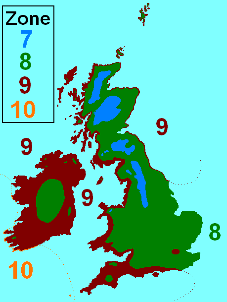
Hardiness zones
 Ireland's (and Britain's) hardiness zones
Most of Ireland is in hardiness zone 9, with the interior being zone 8 and the south-west coast being in zone 10.
Sunshine
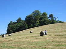 July sunshine in County Cavan
The sunniest months are May and June. During these months sunshine duration averages between 5 and 6½ hours per day over most of the country. The south-east gets the most sunshine, averaging over 7 hours a day in early summer. December is the dullest month with an average daily sunshine ranging from about 1 hour in the north to almost 2 hours in the south-east. Over the year as a whole most areas get an average of between 3¼ and 3¾ hours of sunshine each day. Irish skies are completely covered by cloud roughly half of the time.
The sunniest part of the island is the south-east coast. Rosslare, County Wexford is the sunniest area, and receives on average 4.33 hours of sunshine per day (1,580.45 hours per year).[13]
The dullest, i.e., least sunny, part of the island is in the northern half of the country. Clones, County Monaghan is the dullest area, receiving on average 3.19 hours of sunshine per day (1,164.35 hours per year).[3]
Precipitation
Rainfall is, by far, the most common form of precipitation on the island.[1]
Rainfall
 Flooded farmland in County Down
Rainfall is extremely common throughout Ireland, although some parts of the west coast receive over four times as much rain as the east coast. Rainfall in Ireland normally comes from Atlantic frontal systems which travel north-east over the Island, bringing cloud and rain. Most of the eastern half of the country has between 750 and 1,000 mm (29.5 and 39.4 in) of rainfall in the year. Rainfall in the west generally averages between 1,000 and 1,250 mm (39.4 and 49.2 in). In many mountainous districts rainfall exceeds 3,000 mm (118.1 in) per year. The wettest months almost everywhere are December and January. April is the driest month generally, but in many southern parts June is the driest.
The average number of "wet days" (days with more than 1 mm (0.039 in) of rain) ranges from about 151 days a year along the east and south-east coasts, to about 225 days a year in parts of the west.
The wettest weather station is that in Valentia Island, County Kerry, which receives 1,430.1 mm (56.30 in) of rain per year, on average.[2]
The driest weather station is Casement Aerodrome, County Dublin, which receives 711.4 mm (28.01 in) of rain per year, on average.[14]
The weather station with the highest number of "wet days" is Belmullet, County Mayo with 193 days per year,[15] while the station with the lowest number of "wet days" is Dublin Airport, County Dublin with 128 days per year.[16]
Rainfall records
- The driest year recorded in Ireland was 1887, with only 356.6 mm (14.04 in) of rain recorded at Glasnevin, County Dublin.
- The longest drought in Ireland occurred in Limerick between 3 April 1938 and 10 May 1938 (37 days).
- The greatest monthly total was 790.0 mm (31.10 in); recorded at the Comeragh Mountains in October 1996.
- The greatest annual total was 3,964.9 mm (156.10 in); recorded at Ballaghbeena Gap in 1960.
- The greatest hourly total was 97 mm (3.82 in); recorded at Orra Beg, County Antrim, August 1980.
- The greatest daily total was 243.5 mm (9.59 in); recorded at Cloore Lake, County Kerry on 18 September 1993
Snowfall
 Snow in Wicklow
Severe cold weather is uncommon in Ireland with the majority of winter precipitation coming in the form of rain. Although hills and mountainous regions in the country can see up to 30 days of snowfall annually, most low lying regions of the island only see a few days of lying snow per year (from December to March inclusive), or may see no snow at all during some winters. However, in recent winters, there has been a significant increase in prolonged "cold snaps", in which heavy snow does fall across Ireland for several weeks, often causing disruption to traffic and services across Ireland. Consequently, there have been increased calls to prepare the country for snow and ice, including the distribution of grit, salt, and other snow-treatable minerals. In late 2011, the Irish Government set up "Winter-Ready", in order to prepare the country for such severe weather.[citation needed]
Due to the volatility of Ireland's weather (which is mainly because of the influence of the Atlantic Ocean, Gulf Stream and North Atlantic Drift, as well as Ireland's Northerly latitude and vulnerability to Siberian/Arctic winds) weather during the Winter months is very variable and difficult to predict, with the aforementioned factors making both extremely low temperatures and relatively mild temperatures possible.
The snowiest weather station is that in Clones, County Monaghan; which receives, on average, nearly 30 days of snow and/or sleet per year. Of these, 10.8 days have snow lying at 09:00.[3]
The least snowy weather station is that in Valentia Island, County Kerry; which receives, on average, 5.6 days of snow and/or sleet per year. Of these, 0.8 days have snow lying at 09:00.[2]
Hail
Hail, like snow and sleet, is also rare in Ireland; however it can occur at any time of the year.
Malin Head, County Donegal receives the most hail; with there being 48.4 days per year with hail falling.[17]
Roches Point, County Cork receives the least hail; with there being 8.0 days per year with hail falling.[18]
Thunder
Thunder is most common in Ireland late in summer; though can occur at any time of the year.
Cork Airport, County Cork experiences the least thunder; receiving it 3.7 days per year on average.[19]
Valentia Island, County Kerry experiences the most thunder; receiving it 7.1 days per year on average.[2]
Wind
Generally, the coast tends to be windier than inland areas; and the west tends to be windier than the east.
The station with the highest mean wind speed is Malin Head, County Donegal; averaging at 16.3 kn (30.2 km/h; 18.8 mph). Malin Head also receives the most gale force winds, recording them on average 66.0 days per year.[17]
The station with the lowest mean wind speed is Kilkenny, County Kilkenny; averaging at 6.5 kn (12.0 km/h; 7.5 mph).[20]
The station that records the least amount of gale force winds is that in Birr, County Offaly; recording them on average 1.2 days per year.[21]
The highest wind speed ever recorded in Ireland was 200 km/h (124 mph; 108 kn) at Kilkeel, County Down on 12 January 1974.
Tornadoes are very rare in Ireland, with around less than ten reported every year - mostly in August.[22]
Fog
 Fog in the Wicklow Mountains
Fog is more common inland and on higher altitudes; mainly during winter and during the morning at times of high pressure.
The foggiest station is that at Cork Airport, County Cork, which has 99.5 days of fog per year.[19]
The least foggy station is that at Valentia Island, County Kerry, which has 8.9 days of fog per year.[2]
Recent records
Rainfall
Rainfall records Year 2010 2009 2008 2007 2006 2005 Highest annual total 1,332 millimetres (52.4 in)
Valentia Observatory2,175 millimetres (85.6 in)
Valentia Observatory1,673 millimetres (65.9 in)
Valentia Observatory1,351 millimetres (53.2 in)
Valentia Observatory1,761 millimetres (69.3 in)
Valentia Observatory1,500 millimetres (59 in)
Valentia ObservatoryLowest annual total 671 millimetres (26.4 in)
Dublin Airport918 millimetres (36.1 in)
Dublin Airport944 millimetres (37.2 in)
Dublin Airport755 millimetres (29.7 in)
Rosslare678 millimetres (26.7 in)
Casement Aerodrome624 millimetres (24.6 in)
Casement AerodromeHighest daily rainfall 86.5 millimetres (3.41 in)
Knock Airport
6 September51.2 millimetres (2.02 in)
Cork Airport
19 November102.0 millimetres (4.02 in)
Belderrig
13 August53.3 millimetres (2.10 in)
Phoenix Park
22 June55.3 millimetres (2.18 in)
Valentia Observatory
25 October66.3 millimetres (2.61 in)
Cork Airport
24 JulySource: Met Éireann / Met Office Temperature
Temperature records Year 2010 2009 2008 2007 2006 2005 Highest mean annual temperature 10.1 °C (50.2 °F)
Valentia Observatory11.1 °C (52.0 °F)
Valentia Observatory11.1 °C (52.0 °F)
Valentia Observatory11.7 °C (53.1 °F)
Valentia Observatory11.4 °C (52.5 °F)
Valentia Observatory
and
Rosslare11.4 °C (52.5 °F)
Valentia ObservatoryLowest mean annual temperature 7.9 °C (46.2 °F)
Knock Airport8.7 °C (47.7 °F)
Knock Airport8.7 °C (47.7 °F)
Knock Airport9.5 °C (49.1 °F)
Knock Airport9.1 °C (48.4 °F)
Knock Airport9.1 °C (48.4 °F)
Knock AirportHighest temperature 26.8 °C (80.2 °F)
Ardfert
23 May28.6 °C (83.5 °F)
Galway
2 June25.9 °C (78.6 °F)
Ardtarmon
28 July
and
Castlederg
28 July26.9 °C (80.4 °F)
Ballyshannon
9 June32.3 °C (90.1 °F)
Elphin
19 July30.3 °C (86.5 °F)
Kildalton
12 JulyLowest temperature −18.7 °C (−1.7 °F)
Castlederg
23 December−10 °C (14.0 °F)
Mullingar
25 December−8.8 °C (16.2 °F)
Katesbridge
18 February−8 °C (17.6 °F)
Cavan
7 February−8.6 °C (16.5 °F)
Straide
3 March−5.6 °C (21.9 °F)
Casement Aerodrome
3 MarchSource: Met Éireann / Met Office Sunshine
Sunshine records Year 2010 2009 2008 2007 2006 2005 Highest annual total 1,771 hours
Cork Airport1,561 hours
Dublin Airport1,512 hours
Dublin Airport1,789 hours
Rosslare1,710 hours
Rosslare1,619 hours
RosslareLowest annual total 1,530 hours
Knock Airport1,319 hours
Knock Airport1,249 hours
Birr1,330 hours
Knock Airport1,304 hours
Knock Airport1,147 hours
BirrHighest daily sunshine 16.0 hours
Casement Aerodrome
20 June16.0 hours
Casement Aerodrome
24 June15.3 hours
Malin Head
26 May15.6 hours
Knock Airport
4 June
and
Malin Head
6 June15.8 hours
Malin Head
25 June15.6 hours
Rosslare
11 July
and
Dublin Airport
11 JulySource: Met Éireann / Met Office Visibility
Visibility is generally very good, because of the proximity of industry to the coast, allowing breezes to disperse any smoke.[23] Mist and fog often occur, as well as coastal fog in the east,[24] but it is generally not long-lasting. However in winter, it can be slow to clear.[23]
See also
References
- ^ Peel, M. C. and Finlayson, B. L. and McMahon, T. A. (2007). "Updated world map of the Köppen–Geiger climate classification". Hydrol. Earth Syst. Sci. 11: 1633–1644. ISSN 1027-5606. http://www.hydrol-earth-syst-sci.net/11/1633/2007/hess-11-1633-2007.html. (direct: Final Revised Paper)
- ^ a b c d e Met Éireann - Valentia Observatory (30 Year Averages)
- ^ a b c Met Éireann - Clones (30 Year Averages)
- ^ Met Éireann - Mullingar (30 Year Averages)
- ^ Met Éireann - Temperature
- ^ "N Ireland 1971-2000 averages". Meteorological Office. http://www.metoffice.gov.uk/climate/uk/averages/19712000/areal/n_ireland.html. Retrieved 2008-05-17.
- ^ "Days of Air Frost 1971-2000". Meteorological Office. http://www.metoffice.gov.uk/climate/uk/averages/19712000/daf/17.gif. Retrieved 2008-05-18.
- ^ "Days of Ground Frost 1971-2000". Meteorological Office. http://www.metoffice.gov.uk/climate/uk/averages/19712000/dgf/17.gif. Retrieved 2008-05-18.
- ^ Met Éireann - Roches Point (30 Year Averages)
- ^ Met Éireann - Kilkenny (30 Year Averages)
- ^ Met Éireann - Dublin Airport (30 Year Averages)
- ^ Met Éireann - Casement Aerodrome (30 Year Averages)
- ^ Met Éireann - Rosslare (30 Year Averages)
- ^ Met Éireann - Casement Aerodrome (30 Year Averages)
- ^ Met Éireann - Belmullet (30 Year Averages)
- ^ Met Éireann - Dublin Airport (30 Year Averages)
- ^ a b Met Éireann - Malin Head (30 Year Averages)
- ^ Met Éireann - Roche's Point (30 Year Averages)
- ^ a b Met Éireann - Cork Airport (30 Year Averages)
- ^ Met Éireann - Kilkenny (30 Year Averages)
- ^ Met Éireann - Birr (30 Year Averages)
- ^ BreakingNews.ie - Yesterday’s tornados ‘almost unheard of’
- ^ Cite error: Invalid
<ref>tag; no text was provided for refs namedMet_Office:Northern_Ireland_climate; see Help:Cite errors/Cite error references no text - ^ "Northern Ireland: Climate". Encyclopædia Britannica. http://www.britannica.com/eb/article-44640/Northern-Ireland. Retrieved 2008-05-17.
External links
Climate of Europe Sovereign
states- Albania
- Andorra
- Armenia
- Austria
- Azerbaijan
- Belarus
- Belgium
- Bosnia and Herzegovina
- Bulgaria
- Croatia
- Cyprus
- Czech Republic
- Denmark
- Estonia
- Finland
- France
- Georgia
- Germany
- Greece
- Hungary
- Iceland
- Ireland
- Italy
- Kazakhstan
- Latvia
- Liechtenstein
- Lithuania
- Luxembourg
- Macedonia
- Malta
- Moldova
- Monaco
- Montenegro
- Netherlands
- Norway
- Poland
- Portugal
- Romania
- Russia
- San Marino
- Serbia
- Slovakia
- Slovenia
- Spain
- Sweden
- Switzerland
- Turkey
- Ukraine
- United Kingdom
- (England
- Northern Ireland
- Scotland
- Wales)
- Vatican City
States with limited
recognition- Abkhazia
- Kosovo
- Nagorno-Karabakh
- Northern Cyprus
- South Ossetia
- Transnistria
Dependencies
and other territoriesOther entities - European Union
- Sovereign Military Order of Malta
Categories:- Climate by country
- Environment of Ireland


Wikimedia Foundation. 2010.