- Eglinton Tournament Bridge
Infobox Bridge
bridge_name = Eglinton Tournament Bridge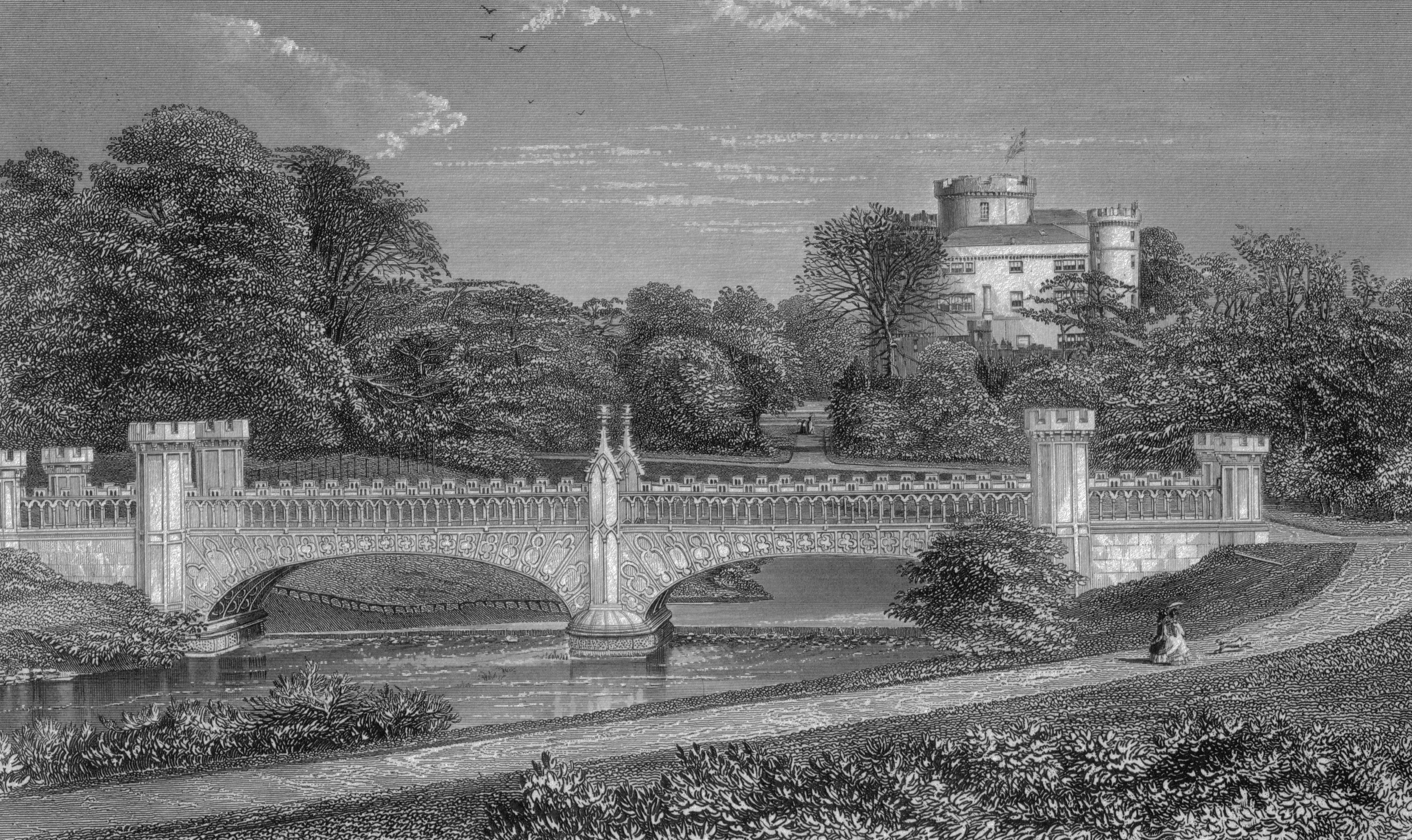
caption = Tournament Bridge and castle in 1876Dobie, James (1876). "Pont's Cuninghame" Pub. John Tweed.]
official_name = Tournament Bridge
carries = Pedestrians
crosses =Lugton Water
locale =Eglinton Country Park
maint =North Ayrshire Council Historic Scotland
id =
design = Gothic
mainspan =
length =
width =
height =
load =
clearance =
below =
traffic =
begin =
complete =
open = c. 1845
closed =
toll =
map_cue =
map_
map_text =
map_width =
coordinates = coord|55.6446|-4.6699|type:landmark_region:GB|display=inline,titleThe Eglinton Tournament Bridge is abridge located withinEglinton Country Park nearKilwinning ,North Ayrshire ,Scotland . The bridge crosses theLugton Water a short distance northwest ofEglinton Castle (OS ref: oscoor|NS32064224|NS32064224) and was named after theEglinton Tournament of 1839 . The castle and surrounding grounds were once home to the Montgomerie family, Earls of Eglinton and chiefs of theClan Montgomery .History
The Tournament Bridges
The surviving Tournament Bridge was built to provide an appropriate crossing point to gain access to the far side of the
Lugton Water . Archibald Montgomerie, the 13thEarl of Eglinton had the bridge built in a Gothic style, using cast iron for the arches, pinnacles, etc. and stone for the two pairs of miniature ornamental towers at either end. These towers have subtle design differences (See photographs) which are significant in the context of the extended history of the bridge. This 'Tournament' bridge was designed by the architect David Hamilton. The bridge's cast ironparapet is a repetition of the pointed Gothic arch design of the castle, surmounted by a battlement, and relieved in the centre with foliatedpinnacle s.Millar, A. H. (1885). "The Castles and Mansions of Ayrshire.' Reprinted by The Grimsay Press (2004). ISBN 1-84530-019x. P. 74.] The Tournament Bridge is B listed byHistoric Scotland . [http://www.historic-scotland.gov.uk/gardens_search_more_info.htm?s=eglinton+castle&r=Glasgow%2c+Clyde+and+Ayrshire&bool=1&PageID=2374&more_info=Site Historic gardens] ]The
1839 Eglinton Tournament was held on a meadow or holm at a loop in the Lugton Water. Most of the holm no longer exists, the excavations in this area having provided gravel and sand for the construction of the Kilwinning bypass and leaving behind an excavation pit which is now known as Eglinton Loch. The Knights on horseback and their retinue reached the tilt yard ('C' on the map) via an enclosed ride ('G' on the map), whilst the guests and visitors made their way to the stands via the route marked 'F' on the map illustrated. Both groups crossed over the previous three arched Gothic bridge. A map of 1837 of "Eglinton Castle, Grounds and Tilt yard" of 1837 shows that the tilt yard was already in extistence at this early date, but it is not recorded what its fate was after the tournament was over.Anstruther, Ian (1986). "The Knight and the Umbrella. An Account of the Eglinton Tournament 1839". Pub. Alan Sutton. Gloucester. ISBN 0-86299-302-4. P. III.]The 'new' Tournament Bridge served as a well used route across the Lugton Water, running through the deer park to the Eglinton kennels (previously Laigh Moncur), especially on days when the Eglinton Hunt met at the castle itself. The original bridge, also with two miniature towers, but with three arches and four pinnacles, stood roughly 100 yards further up the river towards the castle,Ness, J. A. (1969 - 70). Landmarks of Kilwynnyng. Privately produced. P. 29. as shown in several contemporary prints and maps as illustrated in the appropriate gallery of this article.Aitken, Robert (1829). "The Parish Atlas of Ayrshire - Cunninghame." Pub. W. Ballantine. Edinburgh.] It was this bridge that was used at the Eglinton Tournament as can be seen from the illustrations of the event, however the name was passed on to the 'new' bridge constructed downstream of it. No clear sign of this three arched bridge remains, a weir having been built at its old position; the 'old' bridge was constructed in 1811Close, Rob (1992), "Ayrshire Buildings." Royal Incorporated Architects of Scotland. ISBN 1873-190-069. P. 64.] [http://www.ayrshireroots.co.uk/Towns/Kilwinning/Kilwinning%20Historical%20Timeline.htm Ayrshire Roots] ] , therefore around the time of the 'new' castle being built in 1801/2 and also when the grounds were being laid out by Tweedie.
Surviving architects drawings show the designs for a three arched bridge and as stated, contemporary prints of the Eglinton Tournament also show a three arched Tournament bridge, with cast iron arches, pinnacles and parapets which may have been re-used in the later 'new' bridge which survives today.
The point at which the 'old' bridge crossed the Lugton was 102 feet broad and 100 yards downriver from the castle.Aiton, William (1811). Extract from the General View of the Agriculture of Ayr.] It had the Montgomerie coat of arms in the centre. Aiton describes it as being under construction in 1811.Aiton, William (1811). Extract from the General View of the Agriculture of Ayr.] The miniature castle towers on the demolished bridge are shown as each being surmounted by a double cross, but these do not figure on the 'new' Tournament Bridge; the 'old' bridge therefore may have been specially embellished for the tournament with temporary additions.A local minister, the Rev. Lee Ker, confirms which bridge was used at the tournament by relating in his book on
Kilwinning that the tournament procession passed over the Water of Lugton by "what is now called the Tournament Bridge, but which was then situated about 100 yards nearer the Castle and had three arches instead of two."Ker, Rev William Lee (1900). "Kilwinning" Pub. A. W. Cross, Kilwinning. P. 326.] This distance coincides with a weir today and an old path from the castle leads directly to it. Dane Love states that the bridge used by the tournament had been built by the 12th Earl in 1811.Love, Dane (2003). "Ayrshire: Discovering a County." Pub. Fort. Ayr. ISBN 0-9544461-1-9. P. 54.] In contemporary reports of the tournament no special mention of the bridge is made, suggesting that it was already a well established feature of the estate by that time and not an extravagant new feature specially built for the event.LauchlanLauchlan, Roy (1989). "Questions & Answers about the Montgomerie Family and the 1839 Tournaments." Pub. Kilwinning & District Preservation Society. P. 12.] confuses the issue by stating that an older bridge with three arches existed 100 yards up from the present one, however he states that the present bridge was built for the tournament. The old three arched bridge in fact still existed in 1840Leighton, John M. (1850)."Strath Clutha or the Beauties of the Clyde." Pub. Joseph Swan Engraver. Glasgow. Facing P. 229.] and at least as late as 1843."The Ayrshire Wreath MDCCCXLIII (1843): a collection of original pieces, in prose and verse, chiefly by native authors, on subjects relating to Ayrshire." Pub. H. Crawford & Son. Kilmarnock. Facing Title page.]
Construction of the 'new' Tournament Bridge
The new bridge may have been erected by the 13th Earl at some time between 1843 and 1856 as part of the total re-modelling of the course of the Lugton Water which had been first undertaken by the 12th Earl (1740 - 1819)"Landscape of the Knights. The Eglinton Story." Rub. Irvine Development Corporation. 1992. P. 27.] and which included the alteration of its course, the removal of the lakes or ponds and the creation of several weirs. The Lugton Water is liable to severe floodsThe Eglinton Archive.] and damage to the easily broken cast iron work by the force of the current, may have been a reason for its reconstruction at a different site. The first
Ordnance Survey map of 1856 shows the two arched bridge in position, a weir at the position of the old bridge and by this time the old lake had gone, replaced by a canalised Lugton Water with several weirs. Ironically the strengthening work done on the 'new' bridge to produce an extra arch of bricks in addition to the cast iron, may have weakened the structure, contributing to its eventual partial collapse.North Ayrshire Council, Roads and Transportation services. 2008] The army used the bridge extensively with large lorries and even tanks crossong over it.The lower courses of ashlar [http://en.wikibooks.org/wiki/A_Researcher%27s_Guide_to_Local_History_Terminology - Ashlar] ] on the bridge abutments and central pier were vermiculate. [http://en.wikibooks.org/wiki/A_Researcher%27s_Guide_to_Local_History_Terminology - Vermiculate stonework] ] At some point the height of the weir beneath had been raised using an odd assortment of re-used stonework; this would have increased the depth and extent of the waters behind it. The central pier and the original weir had used reworked but re-cycled stone, probably from Kilwinning Abbey; as illustrated by a stone window surround recovered during restoration work (See illustration).
Examination of the top of the outer towers shows that something was attached to the centres, the 'plug' hole still being present. It is possible that the holes are relate dto the method of lifting them into position during construction work. The larger towers are capped with cement and nothing is therefore visible. During restoration work (2008) electricity power cables or possibly gas pipes were located leading to the bridge and they may have served lights on top of some or all of the towers.North Ayrshire Council, Roads and Transportation services. 2008] These are not visible in the available illustrations. The Eglinton estate had its own gasworks and later its own power station, so it would have been natural to provide lighting on the bridge. The old OS maps show that by 1897 the gas works had been established here to supply the castle and offices, whilst by 1911 this had been replaced by an electricity works; the present day park workshop.
The larger and taller inner towers appear to have been re-used from the older bridge, this being confirmed by the presence of ornate carving which is now obscured by the low wall leading to them from the smaller towers. The curtain walls and the smaller and lower outer towers are made from a different type of stone and, as stated, the towers have a number of architectural differences, suggesting that they were made specifically for the 'new' Tournament Bridge (See photographs). During work on the central pier it was found that some of the hidden infill work is vermiculate ashlar from the 'old' bridge.
The cast iron sections of the arches are numbered and some of the sequence are absent, suggesting that these missing sections may have been damaged previously beyond repair and were not used therefore in the 'new' bridge.
Older bridges gallery
The 'new' Tournament Bridge
The Tournament Bridge and WWII
The Eglinton Castle Estate was requisitioned during
World War II and during this occupation the Tournament Bridge partly collapsed, partly due to alterations which had been made earlier by the Eglinton Estate, involving supposed strengthening using brickwork, as revealed during the 2008 restoration work.North Ayrshire Council, Roads and Transportation services. 2008] The bridge was never designed to take the heavy army lorries and tanks which used the bridge during the army occupation of the site and this led to a partial collapse in the 1940s. To save the bridge from total collapse the army Royal Engineers Regiment removed the cast iron outer facia coverings and the pinnacles, encasing the remaining cast iron arches in concrete as can be seen from contemporary photographs and as further revealed during restoration work. It is not known what happened to the pinnacles and cast iron coverings. It had been thought that they were safely in storage, however enquiries have led to nothing.North Ayrshire Council, Roads and Transportation services. 2008]Repair work
Other estate bridges
Originally the river would have been crossed by simple fords, however by the 18th century ornamental pleasure gardens had been formed and these were partly situated in what later became the deer park. No signs of these gardens are now visible, apart from
Crop mark s on aerial photographs taken around the end of the Second World War. A bridge was necessary to give access to the ornamental gardens and one is indicated on John Ainslie's map dated 1790, crossing the Lugton Water close to the castle itself. A small wooden bridge across the Lugton Water is shown in an illustration from around 1815, however this may not have been across the Lugton Water. Thomson's map of 1828 (See illustration) indicates a bridge crossing the Lugton Water at the castle where the three arched bridge was and a drive starting off at the position of the present day bridge, which may have been a ford at the time. Another bridge is suggested further upstream and close to the castle.Thomson, John (1828). A Map of the Northern Part of Ayrshire.] The wooden Laundry Bridge stood close to the castle and downstream from it was second wooden bridge which was washed away in a storm in 1938. Local children used it to build rafts. The restored Stables Bridge, also called Lady Jane's Bridge, lies on the Kilwinning Lodge drive and just downstream from it stood an elegant cast-iron bridge with a 50 foot span.Aiton, William (1811). Extract from the General View of the Agriculture of Ayr.] This bridge had high quality stonework on both of the abutments, much of which survive. This bridge gave access to the kitchen walled gardens and glasshouse ranges and lasted into the mid 1940s when the army removed it.The Suspension Bridge built by the army in the 1980s on behalf of the country park lies just below the weir beside the ruined gazebo. Lady Jane's cottage had a wooded pedestrian footbridge of which no sign remains.
The restored Diamond Bridge lies upstream near the Eglinton Loch and continues to give access to the old Toll Road from Irvine to Kilwinning via
Fergushill . This bridge was named after the nearby Black Diamond mine, the spoil heap or bing of which still remains rear the Chapelholm Gate. The colliery name in turn was associated with one of the 13th Earl's favourite horses, Black Diamond.A Gallery of the other bridges
Lugton Water
The Lugton Water was diverted and altered several times, for example in the 1790s its course was altered by the 12th Earl (1740 - 1819)"Landscape of the Knights. The Eglinton Story." Rub. Irvine Development Corporation. 1992. P. 27.] to run behind the Garden Cottage, rather than in front of it. The width was also changed at times, for instance five ponds or lakes were created by large weirs at one stage; the one at the Tournament Bridge is clearly visible in older prints of the 1840s (see illustrations) shown.Montgomeries of Eglinton. Ayr Division. Strathclyde Department of Education. P. 94.]
The size, shape and position of the various weirs was altered several times, latterly by Clement Wilson of the canning factory. One of the weirs lies directly beneath the restored Tournament Bridge. The one below the site of the old
Bowling Green andRobert Burns 's garden was 'U' shaped, holding back sufficient water at one time to form a lake with a small island bearing a singleyew tree. The 1938 OS map shows no fewer than seven weirs between the castle and the present day Suspension Bridge.The Clement Wilson gardens
In 1948 the Trustees of the late 16th Earl sold most of the remaining parts of the estate to Robert Howie and Sons of
Dunlop for £24,000"Landscape of the Knights. The Eglinton Story." Rub. Irvine Development Corporation. 1992. P. 12.] Sharp, Cameron (2007). "Eglinton Country Park Management Plan for 2007 - 2011". North Ayrshire Council. P. 5.] and in the 1950s the Wilson family purchased the Tournament Bridge, old offices, castle ruins, and other land from Robert Howie and Sons.Clement Wilson, the food processing factory owner, established the Clement Wilson Foundation which opened part of the grounds to the public, spending around £400,000 (around £4,317,000 in 2008 terms) on partially restoring the Tournament Bridge, consolidating the castle ruins, planting trees, landscaping, making paths, creating a rockery and waterfall feature, etc.Wilson, James (2008). Eglinton Archives - Written correspondence.]
2008 restoration
The restoration of the Tournament Bridge involves a faithful and historic renovation of the Tournament Bridge, based on surviving documentary evidence.
Historic Scotland requires a ‘faithful restoration where all details are replicated as closely as possible in terms of material, design and construction’.The existing concrete arches are to be removed as is the infill above. The arches will be replaced with the existing refurbished cast iron arch sections and new cast iron fascia sections, which will restore the original width of the structure. A secondary stainless steel pedestrian parapet is to be provided immediately behind the ballustrading. The load bearing capacity of the bridge will be carried by a modern steel structure concealed beneath the deck surface which will be timber, as this was considered to be the original material. [http://www.north-ayrshire.gov.uk/chiefexec/minutes.nsf/6939f82190c5aae2802572dd0046f16c/2e30178e790d6ec8802573f300400832?OpenDocument Minutes of North Ayrshire Council Executive Committee] ]The current timber parapets will be replaced with cast iron sections to match the original items. All of the cast iron elements are to be fabricated and fitted by the Ballantine
Bo'ness Iron Company to restore the splendour of the original structure.The Irvine Herald, Friday 25th April, 2008. P. 10.]The restoration involved
hydrodemolition to expose the cast iron arches through removing the concrete in which they had been embeded. This process used very high pressure water jets and confirmed the poor structural integrity of the iron arches. They were not however intended to be load bearing in the restored bridge and an upside was the degree of Gothic artwork found to exist on the arches.North Ayrshire Council, Roads and Transportation services. 2008]The estimated total project cost is £720k. Historic Scotland have indicated that they would be able to contribute some £161k, around £5k will be provided in kind, and the shortfall of £354k was the subject of the successful grant application to the
Heritage Lottery Fund . [http://www.north-ayrshire.gov.uk/ChiefExec/CommRA07.nsf/e9ee67f48fbb9003802569d700533758/1f6211e0e2530ce4802573e60045da0f?OpenDocument North Ayrshire Council minutes and the Tournament Bridge restoration] ]2008 restoration gallery
See also
*
The Iron Bridge - the world's first iron bridgeReferences
Wikimedia Foundation. 2010.