- Lawncrest, Philadelphia, Pennsylvania
-
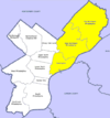
Lawncrest is a neighborhood in the "Near" (lower) Northeast Philadelphia, Pennsylvania. The name is an amalgram of Lawndale and Crescentville, the two primary communities that make up the neighborhood.
The community can trace its roots back to the 19th century as a small German community known to some as Marburg. Parts of Crescentville were known as "Grubbtown" during the Civil War. The main artery of the community, Rising Sun Avenue, was originally a toll road known as the Kensington & Oxford Turnpike. A sole remaining marker of this toll road once stood in front of the Engine 64 Firehouse at Rising Sun and Benner, near the bus stop. Today, only its base remains after it was destroyed in the 1960s by an auto accident.
The area of Lawncrest extends from Godfrey Avenue to Longshore Avenue. Adjacent neighborhoods include: Burholme to the north, Oxford Circle/Castor Gardens to the east, and Olney to the south. To the West is Cheltenham Township, Montgomery County. The Newtown Branch/New York Short Line of the Reading Railroad (now SEPTA/CSX) separates Lawncrest from Montgomery County. Tookany/Tacony Creek also skirts through a portion of the Community.
The community has excellent public transportation. Two SEPTA Fox Chase Line Regional Rail stations serve the community: Lawndale Station at Robbins and Newtown Aves and Cheltenham Station at Martins Mill Road and Hasbrook Ave. These two small community stations see an average daily ridership of over 1000 people, mostly from the Lawncrest Community. Oddly enough, due to the way the county lines are drawn, Lawndale Station actually is located within Cheltenham Township/Montgomery County, while Cheltenham Station is actually within Lawndale/Philadelphia County.
Crescentville Station, closed in the 1970s, was located at the bottom of Godfrey Ave, behind Bond Bread and was nothing more than a dirt/gravel platform. A second Crescentville Station, which served the Frankford Branch of the Reading RR, was located directly behind the Bond Bread building on the south side of the railroad right of way. It was closed when passenger service ended on that branch in the 1930s.
Several SEPTA bus lines also serve the community. The route 18 bus runs from Cedarbrook Mall–Olney Terminal up to Fox Chase using Rising Sun, while the routes 19, 24, 26 and 67 buses serve the Eastern portions of the neighborhood, connecting to the Olney, Frankford and Fern Rock Transportation Centers via direct service or single transfer. All routes have connecting service to the Broad Street subway and Market-Frankford elevated lines.
The primary ZIP Code is 19111 (Fox Chase Post Office) for the area North of Comly Street and 19120 (Olney P.O.) for the area South of Comly Street. Most of the southern end of the Community is actually built on the former property of the Wentz Farm. Portions of the East side of Crescentville are actually built over former swamp land, while the West side was built on more stable bedrock.
Rising Sun Avenue is usually identified as the main artery through Lawncrest, though originally, Ashmead Road/Levick Street was the primary Road. The business area along "the Avenue" is commonly known for its numerous pizza parlors, small "mom 'n' pop" stores and doctors' offices. There are a good number of corner stores, hair salons, bars and even a couple Chinese take-out places that line the avenue as well. Two movie theaters once served the Lawncrest Community, the Lawndale at Rising Sun and Fanshawe Street and the CREST at Rising Sun and Cheltenham Ave. Only the Lawndale remains, now as a day care center. The Crest was torn down to make way for a 7-Eleven in 1988.
St. William's Parish, founded in 1920, covers most of the Crescentville end of the community and part of the lower end of Lawndale, from Magee Avenue South, while the upper end of Lawndale approximately covers the area of Presentation B.V.M. Parish which was founded in 1890. There are about a dozen Protestant Churches within the Community, the oldest being Trinity Oxford Church which dates back to 1698.
Contents
Recreation
In the heart of the community is the 18-acre (73,000 m2) Lawncrest Recreation Center and fields which was built on the location of an old City Reservoir. Also on this property are the Free Library of Philadelphia Lawncrest Branch, built in the 1960s and the Engine 64 Fire House built in 1924. The recreation area includes fields to play sports and other activities. There are tennis courts and basketball courts as well as a roller hockey rink, several baseball diamonds and the pool. Soccer is also played on the central fields in the Fall. Inside the Recreation Center there is a basketball court, gym, auditorium with stage, dance room and meeting rooms. The Lawncrest Athletic Association, created back in the 1950s, has since ceased operations. The LCAA was a non-profit organization that saw its peak in the 1980s when close to 1000 kids would be annually registered for the various activities during the summer months. Parents and volunteers conducted leagues for children aged 6 and up to play sports over the vast playing fields for a nominal fee. The LCAA offered baseball, softball, soccer, and, early in its history, football.
The Rec still offers a summer day camp for kids and a pre-school program known as 'Tot-rec'. The Rec is decorated with murals throughout. The gym is open during the day and is free for use.
Aside from the Lawncrest Recreation Center, Gibbons Police Athletic League (PAL) is located at the intersection of Longshore and Rising Sun Avenues in Lawndale on the property of the Trinity Oxford Church. There is a field at PAL for baseball and two basketball courts inside the building.
Schools
Most teens who live in Lawncrest attend either Cardinal Dougherty High School (Catholic-private) (Now closed), Northeast High School (Magnet-public), or Samuel Fels High School (public). Two Public elementary schools serve the area - Ben Franklin and Creighton and in addition, St. William Parish School, Presentation BVM Parish School and Cedar Grove Academy (in the former Lawndale Public School building) serve the private sector in education.
Other
Most older residents who chose not to remain in their homes, opt to live in one of two retirement homes/communities with the area. The Philadelphia Protestant Home (PPH) offers 3 levels of retirement living. Its campus takes up over 12 acres (49,000 m2) of land and has been within the community since 1889. Pilgrim Gardens also takes up a large portion of land just to the North in Burholme and also traces its routes back to the 1880s.
The community is especially known for its annual 4 July celebration which started back in 1915 as two separate events. The day includes a main parade down Rising Sun Avenue, baby parade, music, activities and a flea market at the Lawncrest Recreation Center, and fireworks at night. Many former residents return to Lawncrest for the 4th of July celebration. People from all parts of the city come here on 4 July as well. You will find people of all ages and backgrounds at the flea market that follows the parade.
Lawncrest saw several population "booms" over the years, particularly during 1920s–1950s era, with Pre and Post WW2 Residents building the neighborhood up from the small farming community it was prior to. There was a second boom in the mid-to-late 80's that saw many baby boomers residing in the community with their children. There has been little in the way of housing construction since the early 1970s. A large majority of the homes are owner occupied and maintained well under pride of ownership. The loss of several major employers in the area between 1970 and 1990 also had an effect on retaining residents in later years. Some of these major employers included: Sears & Roebuck, Canada Dry, Mrs. Pauls, Stokes Vacuum, 3M, Bond Bread, Exide Battery, among many others. While still a large employer, the Naval Inventory Control Point/Defense Supply Center (Commonly referred to locally as the Navy Depot) has reduced its staff from an all time high of 5,000 workers to just over 1,500 in recent years. This facility takes up over 145 acres (0.59 km2) of land in Lawncrest and is a barrier between Lawncrest and neighborhoods to the East with Levick Street and Martins Mill Road providing the only ways in and out.
Notable residents and natives
- Frank Bender, facial reconstruction artist and fine artist.
- Bil Keane, Creator of "Family Circus" comic strip.
- Andrea McArdle, original Annie on Broadway, singer, actress
Neighborhoods of the Northeast section of Philadelphia, Pennsylvania Academy Gardens • Ashton-Woodenbridge • Bridesburg • Burholme • Bustleton • Byberry • Castor Gardens • Crescentville • Crestmont Farms • Fishtown • Fox Chase • Frankford • Harrowgate • Holme Circle • Holmesburg • Juniata • Kensington • Lawndale • Lexington Park • Mayfair • Millbrook • Modena Park • Morrell Park • Normandy • Oxford Circle • Parkwood • Pennypack • Port Richmond • Rhawnhurst • Ryers • Somerton • Tacony • Torresdale • Upper Holmesburg • Winchester Park • Wissinoming
 Categories:
- Neighborhoods in Philadelphia, Pennsylvania

Wikimedia Foundation. 2010.