- Cheshunt Lock
-
Cheshunt Lock 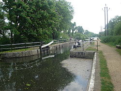
Waterway River Lee Navigation County Hertfordshire Maintained by British Waterways Operation Manual Length 85 feet (25.9 m) Width 16 feet (4.9 m) Fall 5 feet 1 inch (1.5 m) Distance to
Bow Creek14.5 miles (23.3 km) Distance to
Hertford Castle Weir11.8 miles (19.0 km) Geographical Data Coordinates 51°42′36″N 0°01′01″W / 51.710046°N 0.016882°WCoordinates: 51°42′36″N 0°01′01″W / 51.710046°N 0.016882°W Cheshunt Lock (No 9) is a lock on the River Lee Navigation at Cheshunt, Hertfordshire.
Contents
Geography
The lock is located in the River Lee Country Park which is a part of the Lee Valley Park. The Seventy Acres Lake to the east is an important site for the bittern. [1] To the west is North Met Pit another former gravel pit which is popular with anglers and naturalists. [2]
Public access
Pedestrian and cycle access by the towpath which is part of the Lea Valley Walk.
Public transport
Next lock upstream River Lee Navigation Next lock downstream Aqueduct Lock
1.0 mileCheshunt Lock
Grid reference: TL3700003169Waltham Common Lock
1.0 mileReferences
- ^ Bittern information Retrieved May 16, 2008
- ^ North Met Pit Retrieved May 16, 2008
External links
Counties Locks Hertford Lock · Ware Lock · Hardmead Lock · Stanstead Lock · Feildes Weir Lock · Dobbs Weir Lock · Carthagena Lock · Aqueduct Lock · Cheshunt Lock · Waltham Common Lock · Waltham Town Lock · Rammey Marsh Lock · Enfield Lock · Ponder's End Lock · Pickett's Lock · Stonebridge Lock · Tottenham Lock · Pond Lane Flood Gates · Old Ford Lock · Bow LocksWeirs Horns Mill Weir · Hertford Castle Weir · Hartham Weir · Ware Weir · Feildes Weir · Dobbs Weir · Carthagena Weir · Kings Weir · Newmans Weir · Middlesex Filter Beds WeirHertford Union Canal
(branch, below Old Ford)Limehouse Cut
(branch, at Bow Locks)Bow Back Rivers
(branches of the
Old River Lea)Three Mills Lock · City Mill Lock · Carpenter's Road Lock (defunct) · Marshgate Lane Lock (defunct) · Three Mills Wall River Weir
(These rivers form the waterways within the 2012 Olympic Park - they flow into Bow Creek)Categories:- Locks of the Lee Navigation
- Geography of Essex
- Geography of Hertfordshire

Wikimedia Foundation. 2010.