- Shendi
Infobox Settlement
official_name = Shendi
other_name =
native_name =
nickname =
settlement_type =
motto =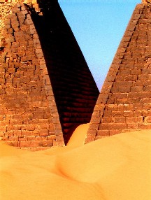
imagesize = 240px
image_caption = Pyramids near Shendi
flag_size =
image_
seal_size =
image_shield =
shield_size =
image_blank_emblem =
blank_emblem_type =
blank_emblem_size =
mapsize =
map_caption =
mapsize1 =
map_caption1 =
image_dot_
dot_mapsize =
dot_map_caption =
dot_x = |dot_y =
pushpin_
pushpin_label_position =bottom
pushpin_map_caption =Location in Sudan
subdivision_type = Country
subdivision_name =
subdivision_type1 = State
subdivision_name1 =River Nile State
subdivision_type2 =
subdivision_name2 =
subdivision_type3 =
subdivision_name3 =
subdivision_type4 =
subdivision_name4 =
government_footnotes =
government_type =
leader_title =
leader_name =
leader_title1 =
leader_name1 =
leader_title2 =
leader_name2 =
leader_title3 =
leader_name3 =
leader_title4 =
leader_name4 =
established_title =
established_date =
established_title2 =
established_date2 =
established_title3 =
established_date3 =
area_magnitude =
unit_pref =Imperial
area_footnotes =
area_total_km2 =
area_land_km2 =
area_water_km2 =
area_total_sq_mi =
area_land_sq_mi =
area_water_sq_mi =
area_water_percent =
area_urban_km2 =
area_urban_sq_mi =
area_metro_km2 =
area_metro_sq_mi =
area_blank1_title =
area_blank1_km2 =
area_blank1_sq_mi =
population_as_of =2007
population_footnotes =
population_note =
population_total =55,516
population_density_km2 =
population_density_sq_mi =
population_metro =
population_density_metro_km2 =
population_density_metro_sq_mi =
population_urban =
population_density_urban_km2 =
population_density_urban_sq_mi =
population_blank1_title =Ethnicities
population_blank1 =
population_blank2_title =Religions
population_blank2 =
population_density_blank1_km2 =
population_density_blank1_sq_mi =
timezone =
utc_offset =
timezone_DST =
utc_offset_DST =
latd=16|latm=41|lats= |latNS=N
longd=33 |longm=26 |longs= |longEW=E
elevation_footnotes =
elevation_m =
elevation_ft =
postal_code_type =
postal_code =
area_code =
blank_name =
blank_info =
blank1_name =
blank1_info =
website =
footnotes =Shendi or Shandi (Arabic: شندي) is a town in northern
Sudan , situated on the east bank of theNile 150 km northeast ofKhartoum . Shandi is also about 45 km southwest of the ancient city ofMeroe . Located in the River Nilewilayah , Shandi is the center of the Ja'aliin tribe and an important historic trading center. Its principal suburb on the west bank is Al-Matamma. A major traditional trade route across the Bayuda desert connects Al-Matamma to Marawi andNapata , 250 km to the northwest. The 1911 Encyclopedia Britannica provides the following historical details:"The origin of the name of the town came from the Daju tribe which inhabited it after being forced to migrate south & south-westward after the fall of Meroé in A.D. 350 which had been invaded by the army of
Ezana , king of Axum (Ethiopia). The word 'sugaŋdé' or 'chendé' means in the Daju language: 'a sheep' (See Browne, W. G. 1806); this indicates that they were herders who moved south & south-westward to Kordofan and Darfur looking for abundant pasture. TheAbabda tribe ofBedouin s settled there in the early 19th century.Johann Ludwig Burckhardt passed through on his way to theRed Sea in 1812, andCharles Rothschild discovered the plague vectorflea "Xenopsylla cheopis " there in 1901."Demographics
Economy
Very basic services and infrastructure mean that Shendi exists mainly as a center for trade in agricultural goods from nearby farms. Regular power cuts mean that expansion of the economy into industry remains impossible at the present time. Tourism related activity from the nearby Meriotic ruins is minimal due to a lack of facilities within the town. There is poor or non-existent sanitation and a lack of running water in most homes and businesses.
Communications
Roads have begun to be laid cross the city however these remain largely unsafe, as is the road to Khartoum. The railway station in the city is no longer used for passenger travel, although freight trains continue to use the tracks. Shendi is home to an airport (
ICAO code HSND).Mobile telephone coverage exists within the city, neighboring towns of
Misiktab and Al Mattamar, outlying villages and the ancient Meriotic pyramids to the north.Institutions
Schools exist within the town and local villages
A UNESCO funded center exists within the town to promote education in foreign languages and Information Technology.
A University exists within the city and draws students from across Sudan to study there, though the student body is of entirely Muslim extraction.
References
* [http://www.fallingrain.com/world/SU/53/Shendi.html FallingRain Map - elevation = 376m]

Wikimedia Foundation. 2010.