- Marsabit
-
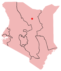
Marsabit is a town in northern Kenya, located 170 km east of the center of the East African Rift at 37°58' E, 2°19' N (37.97°E, 2.32 N). It is located in the Eastern Province and is almost surrounded by the Marsabit National Park and Reserve. It serves as the capital of Marsabit District, and lies southeast of the Chalbi Desert in a forested area known for its volcanoes and crater lakes.
Contents
Marsabit town
The town of Marsabit is an outpost of urban civilization in the vast desert of northern Kenya. The town is situated on an isolated extinct volcano, Mount Marsabit, which rises almost a kilometer above the desert. The hills here are heavily forested, in contrast to the desert beyond, with their own "insular" eco-system.
The town is inhabited by the Nilotic Samburu and Turkana, as well as the Cushitic-speaking Gabbra, Burji, Borana and Rendille. It is also home to some Somali and Ameru traders and migrants.
In addition, Marsabit has an airstrip and a mountain peak (Mount Marsabit), with "singing" wells just outside the town. Elephants can also often be seen in the local wildlife refuge that surrounds the town, occasionally breaking down fences and causing damage to local farmers crop beds.
The town's name is from the Amharic word 'Marsa bet' (Meaning Marsa's home/house) is believed to have been named after a farmer named 'Marsa' (ethnically Burji) who was brought to Marsabit from Mega (in Ethiopia) by the Consul to assist in consolidation of farming and permanent settlement on the slopes of Mount Marsabit.
Culture and religion
 Camels watering in Marsabit in 2005
Besides the aforementioned ethnic groups, there are other people from other parts of Kenya who are there working mostly for the government and business. About 40% of the people living in Marsabit are Christians, 32% Muslims and other 28% believe in traditional religions and others. Mostly, these groups have lived in peace, but starting in 1994 and lasting for almost a year, there were ethnic killings of Gabra by Borana, following a dispute over clan ownership of cattle—which are the main source of income for both groups, in addition to trade in goods and foodstuffs.
Marsabit is the announced location for a conference between Borana and Gabra elders scheduled for 2-6 June 2009. Discussions to resolve existing conflicts between the two groups have been underway for several years now, and agreements are expected to be sealed at the event at this conference in the presence of traditional leaders.[1]
Transport
Marsabit is approximately 550 kilometers or two days' drive from Nairobi via the towns of Isiolo and Archer's Post, by either hanging on top of the trucks or hiking lift in government vehicles a list in transport. There are two airstrips servicing charter aircraft one close to town about 10 minutes Drive towards Moyale (Marsabit Airstrip) and the second about 30 minutes away towards Chalbi. (Segel Airstrip)
Economy
Marsabit town is a trading and commercial center, with three petrol stations, a bank, post office, shops, restaurants, lodges and even a dry cleaner. The town facilitates the supply and movement of goods and services between Moyale (goods from Ethiopia) and Isiolo (goods from Nairobi). Agriculture also plays a role, as many grow millet and maize to be consumed locally and nomadic people supply beef by selling their cows.
Lake Paradise (which attracts game animals such as elephants and buffalo), and Bongole Crater located in the heart of the forest are both local attractions for tourists. The town and surrounding area are of rich cultural interest to anthropologists and other researchers.
Notes
- ^ "Borana and Gabra peace meeting in Dukana", Pastoralists Communication Initiative website (accessed 5 May 2009)
Coordinates: 2°20′N 37°59′E / 2.333°N 37.983°E
Categories:- Marsabit District
- Populated places in the Eastern Province of Kenya


Wikimedia Foundation. 2010.