- M-35 (Michigan highway)
-
M-35
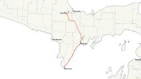
M-35 highlighted in redRoute information Maintained by MDOT Length: 128.388 mi[2] (206.620 km) Existed: ca. July 1, 1919[1] – present Tourist
routes:Lake Michigan Circle Tour, UP Hidden Coast Recreational Heritage Trail Major junctions South end:  US 41 at Menominee
 US 2 / US 41 between Escanaba and Gladstone
 M-553 near Gwinn
North end:  US 41 / M-28 near Negaunee
Location Counties: Menominee, Delta, Marquette Highway system Michigan State Trunkline Highway System
Interstate • US • State←  M-34
M-34M-36  →
→M-35 is a state trunkline highway in the Upper Peninsula (UP) of the US state of Michigan. Running for 127.99 miles (205.98 km) in a general north–south direction, it connects the cities of Menominee, Escanaba and Negaunee. The southern section of M-35 in Menominee and Delta counties carries two additional designations. M-35 forms a segment of the Lake Michigan Circle Tour, and it is the UP Hidden Coast Recreational Heritage Trail, which is a part of the Michigan Heritage Routes system. Along the southern section, the highway is the closest trunkline to the Green Bay, a section of Lake Michigan, and is also the shortest route between Menominee and Escanaba. The northern section of the highway turns inland through wooded terrain, connecting rural portions of Delta and Marquette counties.
M-35 is an original state trunkline that was first designated by July 1, 1919, originally intended to run from Menominee in the south to near Big Bay in the north, before turning toward L'Anse to end at Ontonagon. However, the section through the Huron Mountains in northern Marquette and Baraga counties was never built. Automobile pioneer Henry Ford helped halt this construction to gain favor with and membership in the exclusive Huron Mountain Club. Some discontinuous sections were later ceded to local control. The northern segment of the route between Ontonagon and Baraga was retained as a discontinuous segment of the highway; this northern segment was redesignated as another state trunkline. The northern end was rerouted out of the City of Negaunee into Negaunee Township to avoid mining activity near Palmer.
Contents
Route description
M-35 is primarily a two-lane roadway, with the exception of the 8.418-mile (13.547 km) section between Escanaba and Gladstone.[2] This section is a four-lane divided highway that runs concurrently with US Highway 2/US Highway 41 (US 2/US 41).[3] M-35 is also listed on the National Highway System along the US 2/US 41 concurrency.[4] The southern terminus is in the City of Menominee. From there, M-35 runs northeasterly to the Escanaba area before turning northwesterly to its northern terminus outside of the City of Negaunee in Negaunee Township.[3]
Menominee to Gladstone
 Looking south at M-35 from G-12 in Menominee County
The southern terminus of M-35 is north of downtown Menominee, at the corner of 10th Street (US 41) and North Shore Drive. It is a Y-shaped intersection near John Henes Park. This park sits on 50 acres (20 ha) of land, and it was donated to the City of Menominee by German–American brewer John Henes in 1907.[5] M-35 leads northeast from the intersection before turning north to head out of town. The highway runs northeasterly following the shoreline of the Green Bay, toward Escanaba. M-35 between Menominee and Gladstone forms part of the Lake Michigan Circle Tour.[3]
On August 26, 2007, the Michigan Department of Transportation (MDOT) announced that this section of M-35 was also designated the UP Hidden Coast Recreational Heritage Trail running for 64 miles (103 km) between Menominee and Gladstone.[6][7] As a part of the heritage trail, M-35 passes the mouths of the Cedar and Bark rivers. Wells State Park is located on M-35 in Cedar River[3] and Fuller Park is at the mouth of the Bark River.[8] MDOT's press release states:
The Heritage Route passes through both Delta and Menominee counties on the western shoreline of Lake Michigan in the central Upper Peninsula, and features parks, waterways, forests, trails, attractions, boat launches, harbors and campgrounds. Suggested stops range from cultural centers and modern entertainment, to historical sites and natural attractions.—James Lake, MDOT[9]M-35 is the shortest state trunkline highway between Menominee and Escanaba. Under American Association of State Highway and Transportation Officials (AASHTO) guidelines, US Highways are to follow the most direct path between two locations,[10] but US 41 runs inland and M-35 goes more directly up the Lake Michigan shoreline. According to the 2007 MDOT State Highway Map, the US 41 route runs for 65 miles (105 km) versus 55 miles (89 km) for M-35.[3] The original map for the US Highway System shows US 41 continuing north from Powers on a direct line to Marquette. This routing would be more direct than the current US 41 routing, but has not been built.[3][11]
At the Menominee–Delta county line, M-35 passes from the Central to the Eastern Time Zone.[3] After passing the south side of Escanaba, M-35 runs into town on Lake Shore Drive, passing to the south and east of the Delta County Airport before turning onto Lincoln Road. Just west of downtown, US 2/US 41 join M-35 at the intersection of Ludington Street and Lincoln Road. Ludington and Lincoln form the east–west and north–south axes respectively of the Escanaba street numbering grid. From these two streets, the east–west avenues and north–south streets are numbered in a grid in the City of Escanaba.[12] US 2/US 41 enter Escanaba from the west along Ludington Street, turning north along Lincoln Road, joining M-35. Here, M-35 joins the National Highway System,[4] which is a road system important to the nation's economy, defense, and mobility.[13]
From Escanaba, M-35 runs concurrently with US 2 and US 41 to Gladstone, where M-35 logs its highest average annual daily traffic (AADT) counts. The 2006 AADT figures show that 25,800 vehicles use the highway per day on a segment in north Escanaba.[14] Between the two cities, US 2/US 41/M-35 crosses the Escanaba River near the mouth just south of the paper mill.[15] North of the Escanaba, the highway follows the shoreline of Little Bay de Noc to Gladstone. M-35 separates from US 2/US 41 at an intersection with 4th Avenue North in Gladstone. This also marks the end of the National Highway System, Lake Michigan Circle Tour and Michigan Heritage Route designations on M-35.[3][4][9]
Gladstone to Negaunee
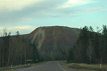 Waste rock piles from the Empire Mine along M-35 southbound approaching Palmer
M-35 turns northwesterly in Gladstone through northern Delta County and southern Marquette County and crosses the Days River in Brampton. From Perkins north, M-35 runs parallel to the Lake Superior & Ishpeming rail line between the iron mines of Marquette County and Escanaba. The station of Maple Ridge was located in the community of Rock along this line. M-35 crosses into Marquette County in the unincorporated location of McFarland and crosses the rail line before reaching the Little Lake in the community of the same name. The highway runs east–west through Little Lake to Gwinn.[3]
Built as a company town by the Cleveland-Cliffs Iron Company, Gwinn is listed on the National Register of Historic Places as the "Gwinn Model Town Historic District, Forsyth Township, Marquette County, Michigan".[16] M-35 follows Stephenson Avenue through the neighborhood of New Swanzy westward to the community of Gwinn. Inside Gwinn, the highway follows Pine Street northwest, passing through the downtown and into residential areas along Pine and Iron streets.[17]
M-35 runs northwest of Gwinn to Palmer along the outskirts of Cleveland-Cliffs' Empire Mine, where large piles of waste rock from the mining operations tower over the roadway. According to MDOT, the segment through Palmer logged the highway's lowest AADT, only 1,200 vehicles per day, in 2006.[18] North of Palmer, M-35 runs past Goose Lake to end in Negaunee Township. The northern terminus is 3.6 miles (5.8 km) east of Negaunee, just east of the former Marquette County Airport and the studios of WLUC-TV6 on US 41/M-28.[19]
History
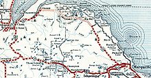 A section of the 1932 Michigan State Dept. of Highways road map showing M-35 in northern Marquette and Baraga counties[20]
The first path along part of the modern M-35 roadway was the Sault and Green Bay Trail, an old Native American trail, between Menominee and Escanaba. This trail continued eastward from Escanaba to Sault Ste. Marie and southerly to Green Bay, Wisconsin. It was a narrow path of approximately 12–18 inches (30–40 cm) in width, wide enough to permit single-file traffic.[21]
When designated by July 1, 1919, M-35 was to run from M-12/M-15 (modern US 2/US 41) at Gladstone in the south to Palmer before terminating in Negaunee at M-15 (modern US 41). Most maps showed M-35 continuing north to L'Anse.[1][20] At the time of M-35's creation, another designation, M-91, was assigned to a highway from Menominee northward to Cedar River.[1] By 1930, M-35 was extended southerly along US 2/US 41 from Gladstone to Escanaba. From there, M-35 continued as a new highway along the Green Bay shoreline to Cedar River and supplanted M-91.[22]
Huron Mountains
In 1919, the State Department of Highways, forerunner to today's MDOT, designated a scenic shoreline trunkline to run north from Negaunee to Skanee and L'Anse by way of Big Bay. The highway would continue from the L'Anse and Baraga area to eventually end at Ontonagon at an intersection with M-64.[22] Local Upper Peninsula historian Fred Rydholm summarized the routing planned in 1925 as extending "... in a northwesterly direction, across the Dead River, over the Panorama Hills, then west past the Elm Creek swamp, along the south side of Burnt Mountain, across the Cedar Creek, the Cliff Stream and out past Cliff Lake to Skanee and L'Anse".[23] This highway was designated as an extension of M-35, which ended in downtown Negaunee. Work was completed on a significant portion of the route in Marquette County by 1926. M-35 was routed east along M-15 toward Marquette before turning north-northwesterly toward Big Bay. This section of roadway follows the modern Marquette County Road 510 (CR 510). Similar work was completed in Baraga County connecting L'Anse and Skanee by 1932.[20]
Construction on the two ends left the center portion through the Huron Mountains unfinished and shown on state maps as a dashed line marked "impassable".[20] The section not included in CR 510, with guard rails and cement culverts[23] has been called "Blind 35" since.[24]
The Steel Bridge
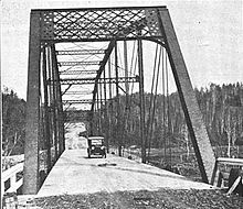 The Steel Bridge carrying M-35 over the Dead River in 1922
One of the first tasks for the State Highway Department was bridging the Dead River in Negaunee Township, 3 miles (5 km) north of US 41.[25] The state solved the problem by buying a bridge in Pennsylvania, where bridges of this design were more common.[25] MDOT describes the bridge as:
... a rare Pennsylvania through truss highway bridge, particularly because of the length [271 feet (83 m)] of this single span. It was purchased by the State Highway Department in 1919, moved from an unspecified Allegheny River site, probably considerably upstream from Pittsburgh, and then erected on this site in 1921.[26]The bridge is still in place over the Dead River and previously carried CR 510 as the successor to M-35 in northern Marquette County.[27] Known locally as "The Steel Bridge", it survived a May 15, 2003 flood caused by the breaching of the Silver Lake Dam.[26][28][29] The Marquette County Road Commission had announced plans in 2006 to bypass the Steel Bridge with a modern replacement, leaving the existing bridge as a footpath or bike path.[30] Construction on the bypass road and replacement bridge was begun in October 2007. The concrete work for the replacement span was started in late 2009, with an original projected completion date of November 1, 2010. The new crossing is 100 feet (30 m) above river level compared to the 10 feet (3.0 m) for the 1921 span. The total budget for bridge construction is $4.5 million with an additional $1.7 million for the approach work, with an 80 percent federal, 15 percent state and 5 percent county funding split.[31] The new bridge opened to traffic in September 2010, diverting traffic from the Steel Bridge. Completion of the new span came after about a decade of planning.[27]
Henry Ford
Records of the Huron Mountain Club, an exclusive private organization with large land holdings in northern Michigan, show that Henry Ford visited the Upper Peninsula many times, including at least once with Harvey Firestone and Thomas Edison on Ford's yacht, Sialia. Many of these trips involved research to keep his operations supplied.[32] His UP land provided wood for the manufacture of Ford automobiles such as the Model T, which required 250 board feet (0.59 m3) of lumber per car.[23] Ford, who was considering becoming the "owner–producer–handler" of the resources he needed, invested in sawmills in Alberta and Kingsford. He also bought the entire town of Pequaming, along the shores of the Keweenaw Bay. The town belonged to Dan Hebard, who also sold Ford a sawmill, tugboats, a 14-room bungalow, and land near the Huron Mountain Club. Hebard retired to spend his summers at a cabin on the Pine River on land belonging to the Club.[23]
Ford built a hydroelectric dam along the Menominee River to supply power to the Kingsford mill, bought the Imperial Mine, and opened the Blueberry Mine near Ishpeming to supply iron ore. The Ford Railroad was constructed between L'Anse and the Cliff River for his logging operations on 300,000 acres (100,000 ha) of timberland purchased in 1922. He often visited the Upper Peninsula on business, but as early as 1917, the year he ran for a seat in the U.S. Senate, he sought entry into the Huron Mountain Club. Since the club limited its membership, Ford worked to improve his chances. His admission would ultimately come when M-35 construction was halted in the Huron Mountains.[23]
Hunters, campers, hikers, fishermen and some landowners opposed highway construction near the Huron Mountains. Rydholm said, "... there seemed to be no groundswell of sentiment in favor of it, but it looked as the though the die was cast and nothing could be done to stop it".[23] The Huron Mountain Club members opposed the highway because it would open vast reaches of the back country and might harm the wilderness. Highway construction would also open the possibility of a resort hotel. William C. Weber, a real estate developer from Detroit, owned property along Mountain Lake, in northern Marquette County. A Michigan attorney general's opinion provided a way for blocking the road if two-thirds of the property over which the road would pass was owned by people opposed to the project. The proposed highway was to cross two 40-acre (16 ha) parcels of Huron Mountain Club property, but that was not enough to halt construction.[32]
In 1926, Hebard was elected the new president at the Huron Mountain Club[23] and changed its rules for admission.[32] Before the changes, all existing members voted on new admissions, and four "no" votes meant rejection. After Hebard's changes, only club directors could vote, and only one "no" was needed to block election.[32] In 1927, the road grading for M-35 had reached the Salmon Trout River. That same year, Ford bought more land near Mountain Lake. This property encompassed more than the requisite two-thirds necessary to stop construction of the road. In 1928, the road was moved to connect with the Big Bay Road (CR 550), leaving the stub of "Blind 35" behind.[23] According to club records, "by 1929, M-35 was dead in its tracks and Henry Ford was a member".[32] To commemorate his membership, Ford built a white pine log cabin on club property that cost between $80,000 and $100,000 in 1929 (equivalent to $1.03 million to $1.28 million in 2011).[23][33]
After Ford
In 1939, M-35 from Negaunee to Big Bay to L'Anse was officially canceled as a state trunkline highway.[34][35] Constructed portions were turned over to local control, becoming Skanee Road in Baraga County and CR 510 in Marquette County. This left a discontinuous routing for 13 years. The southern segment of M-35 ran from Menominee to Negaunee, and the northern segment ran from Baraga to Ontonagon along the modern M-38. The two segments were rejoined in 1953, closing the gap left by the cancelled Huron Mountain route. M-35 signs were added to existing highway signs westward from the end of the southern segment at Negaunee along US 41/M-28 and US 41 to Baraga, to connect with the northern segment westward to Ontonagon.[36]
In 1964, several abandoned underground mine shafts collapsed underneath the roadway, forcing a rerouting of M-35 out of the City of Negaunee.[37] Before the rerouting, M-35 was routed from Palmer north to Negaunee using a portion of County Road near Lucy Hill. It also followed Silver Street connecting with part of BUS M-28, a business loop of M-28, through downtown Negaunee to US 41 north of town. This former segment is still shown on some maps (such as Google Maps) as "Old M-35".[19] Since this rerouting, M-35 runs from Palmer past Goose Lake to end in Negaunee Township. The only naturbahn, or natural track, luge run in North America crosses the former routing of M-35 in Negaunee.[38] This luge run crosses over the abandoned street at the end of County Road at Lucy Hill.[19]
The last major changes to M-35 came in 1968 when the section from Baraga to Ontonagon was given the M-38 designation. The M-35 concurrencies were removed along US 41/M-28 and US 41 in Marquette and Baraga counties. This change shortened the highway designation and moved the northern terminus to the present location in Negaunee Township.[39][40] Since then, sections of the roadway were realigned in Richmond Township south of Palmer to straighten some of the many curves between Palmer and Gwinn on June 2, 1989.[41] MDOT has started construction of a new 20-space commuter parking lot at the southern terminus of M-553 at M-35 on August 11, 2008 with an expected completion date of August 30, 2008. This is part of an effort to offer expanded ride-sharing opportunities in Marquette County.[42]
Major intersections
The following table shows the major intersections along M-35. Included are intersections with county-designated highways and other primary county roads, other state trunklines and U.S. Highways.
County Location Mile[2] Destinations Notes Menominee Menominee 0.000  US 41 / LMCT south
Southern end of LMCT concurrency Cedar River 23.065  G-12 west (Cedar River Road) – Stephenson
Western terminus of G-12 Delta Escanaba 52.227 US 2 west / US 41 south (Ludington Street) – PowersSouth end of US 2/US 41 concurrency Gladstone 59.235  CR 426 west – Arnold
Eastern terminus of CR 426 60.645 US 2 east / US 41 north / LMCT east – Rapid River, MarquetteNorth end of US 2/US 41/LMCT concurrency Brampton 67.955 Brampton Road (27.5 Road) – Rapid River Western terminus of OLD M-186 Marquette Little Lake 97.301  CR 456 west (Little Lake Road) – Skandia
Eastern terminus of CR 456 Gwinn 101.121 M-553 north – MarquetteSouthern terminus of M-553 106.015  CR 557 south – Arnold
Northern terminus of CR 557 Palmer 118.624 
 CR 565 west (Missouri Road) to CR 476 – National Mine
Eastern terminus of CR 565 Negaunee Township 124.781  CR 480 – Negaunee, Sands Township
126.715–
126.744 CR 492
A concurrency of 153 feet (47 m) to cross railroad tracks; M-35 traffic yields to CR 492 128.388  US 41 / M-28 / LSCT – Negaunee, Marquette
1.000 mi = 1.609 km; 1.000 km = 0.621 mi
Concurrency terminus • Closed/Former • Incomplete access • UnopenedSee also
- Interstate 275, another highway in Michigan with a northern extension cancelled by landowner opposition
References
- ^ a b c Michigan State Highway Department (July 1, 1919). State of Michigan: Upper Peninsula (Map). Cartography by MSHD.
- ^ a b c Michigan Department of Transportation (2009). MDOT Physical Reference Finder Application (Map). Cartography by Michigan Center for Geographic Information. http://www.mcgi.state.mi.us/prfinder/. Retrieved April 13, 2010.
- ^ a b c d e f g h i Michigan Department of Transportation (2007). Official 2007 Department of Transportation Map (Map). 1 in.:15 mi./1 cm.:9 km.. Cartography by MDOT. Section E5-F6.
- ^ a b c Michigan Department of Transportation (April 23, 2006) (PDF). National Highway System, Michigan (Map). Cartography by MDOT. http://www.michigan.gov/documents/MDOT_NHS_Statewide_150626_7.pdf. Retrieved February 4, 2008.
- ^ Hunt, "Henes Park".
- ^ Hunt, "M-35 Along the Green Bay Shore".
- ^ "MDOT Declares UP Road as Heritage Route". Negaunee, MI: WLUC-TV. August 28, 2007.
- ^ Hunt, "M-35 Along the Green Bay Shore: Fuller Park".
- ^ a b "M-35 Named UP Hidden Coast Recreation Heritage Route" (Press release). Michigan Department of Transportation. August 26, 2007. http://www.michigan.gov/mdot/0,1607,7-151-9620-174951--,00.html. Retrieved August 29, 2007.
- ^ Staff (October 6, 1996). "Establishment and Development of United States Numbered Highways" (PDF). American Association of State Highway and Transportation Officials. p. 6. http://cms.transportation.org/sites/route/docs/HO1_Policy_Establ_Develop_USRN.pdf. Retrieved May 27, 2009.
- ^ Bureau of Public Roads (November 11, 1926) (PDF). United States System of Highways (Map). Cartography by American Association of State Highway Officials. http://www.okladot.state.ok.us/hqdiv/p-r-div/maps/misc-maps/1926us.pdf. Retrieved May 10, 2008.
- ^ Google, Inc. Google Maps – Escanaba, MI (Map). Cartography by Google, Inc. http://maps.google.com/maps?f=q&hl=en&geocode=&q=escanaba,+mi&ie=UTF8&ll=45.745006,-87.081757&spn=0.018868,0.030212&z=15. Retrieved May 4, 2008.
- ^ Slater.
- ^ Michigan Department of Transportation (2006) (PDF). ADT Map for Escanaba (Map). Cartography by MDOT. http://www.michigan.gov/documents/escanaba_19643_7.pdf. Retrieved May 17, 2008.
- ^ Hunt, "Escanaba".
- ^ Staff (June 24, 2002). "National Register of Historic Places: Michigan, Marquette County". National Register of Historic Places. http://www.nationalregisterofhistoricplaces.com/MI/Marquette/districts.html. Retrieved August 29, 2007.
- ^ Google, Inc. Google Maps – Gwinn, MI (Map). Cartography by Google, Inc. http://maps.google.com/maps?f=q&hl=en&geocode=&q=gwinn,+mi&ie=UTF8&ll=46.278438,-87.435851&spn=0.018687,0.030212&z=15. Retrieved March 16, 2008.
- ^ Michigan Department of Transportation (2006) (PDF). State ADT Map (Map). Cartography by MDOT. http://www.michigan.gov/documents/adtfront_20092_7.pdf. Retrieved May 17, 2008.
- ^ a b c Google, Inc. Google Maps – Negaunee, MI (Map). Cartography by Google, Inc. http://maps.google.com/maps?f=q&hl=en&q=Negaunee,+MI+49866&layer=&ie=UTF8&z=13&ll=46.484683,-87.582321&spn=0.074464,0.176468&om=1. Retrieved March 15, 2007.
- ^ a b c d Michigan State Highway Department (1932). Michigan State Department of Highways Map (Map). Cartography by MSHD.
- ^ Pohl & Brown.
- ^ a b ALA, pp. 45+.
- ^ a b c d e f g h i Rydholm, pp. 508–515
- ^ Rockford Map Publishers (2001). Land Atlas and Plat Book of Marquette County, Michigan (Map) (15th ed.). Rockford, IL. p. 65, Powell Twp. T51N–R27W inset. OCLC 41970440.
- ^ a b Hyde, pp. 70–72.
- ^ a b Staff (April 19, 2002). "County Rd. 510–Dead River". Michigan's Historic Bridges. Michigan Department of Transportation. http://www.michigan.gov/mdot/0,1607,7-151-9620_11154_11188-29396--,00.html. Retrieved February 4, 2008.
- ^ a b Pepin, John (October 4, 2010). "New Bridge Over the Dead River Drawing a lot of Attention, but be Careful". The Mining Journal (Marquette, MI). Archived from the original on February 3, 2011. http://www.webcitation.org/5wDvy5VJS. Retrieved October 21, 2010.
- ^ Grace, Francie (May 16, 2003). "2 Dams Burst In Michigan". CBS News. Archived from the original on February 3, 2011. http://www.webcitation.org/5wDvrIvu0. Retrieved February 4, 2008.
- ^ Egan, Dan (June 8, 2003). "Dike 'Safety Valve' Went Terribly Awry". Milwaukee Journal Sentinel.
- ^ "Plans to Replace Historic Bridge Underway". Negaunee, MI: WLUC-TV. May 2, 2006.
- ^ Pepin, John (June 7, 2010). "510 Bridge Replacement". The Mining Journal (Marquette, MI). Archived from the original on February 3, 2011. http://www.miningjournal.net/page/content.detail/id/545021.html. Retrieved September 13, 2010.
- ^ a b c d e Mayor, pp. 88–89.
- ^ "Consumer Price Index Estimate". Federal Reserve Bank of Minneapolis. http://www.minneapolisfed.org/community_education/teacher/calc/hist1800.cfm. Retrieved March 31, 2009.
- ^ Michigan State Highway Department (May 1, 1938). State of Michigan (Map). Cartography by MSHD.
- ^ Michigan State Highway Department (July 15, 1939). State of Michigan (Map). Cartography by MSHD.
- ^ Michigan State Highway Department (April 1, 1953). State of Michigan (Map). Cartography by MSHD.
- ^ Right of Way for the M-35 Relocation was purchased between March 20, 1964 and October 12, 1964 according to Michigan Department of Transportation. Right of Way Maps for Marquette County, Sheets 73–76 (Map). http://mdotwas1.mdot.state.mi.us/public/ROWFiles/results.cfm?Dir=Marquette. Retrieved May 8, 2008.
- ^ Hunt, "Negaunee: Lucy Hill Naturbahn Luge".
- ^ Michigan Department of State Highways (1968). Official Highway Map (Map). Cartography by MDSH. Section B3–B5.
- ^ Michigan Department of State Highways (1969). Official Highway Map (Map). Cartography by MDSH. Section B3–B5.
- ^ Michigan Department of Transportation (PDF). Right of Way Maps for Marquette County (Map). Cartography by MDOT. Sheet 78 inset. http://mdotwas1.mdot.state.mi.us/public/ROWFiles/files/Marquette/sheet078.pdf. Retrieved May 8, 2008.
- ^ "MDOT Building New Lot for Marquette County Commuters" (Press release). Michigan Department of Transportation. August 19, 2008. http://www.michigan.gov/mdot/0,1607,7-151-9620_11057-198497--,00.html. Retrieved August 26, 2008.
Works cited
- Automobile Legal Association (1930). "Route Log of State Highway Systems". Automobile Green Book (1930–31 ed.). Boston: Scarborough Motor Guide Co. OCLC 24448978.
- Hunt, Mary; Hunt, Don (2007). Hunts' Guide to Michigan's Upper Peninsula. Albion, MI: Midwestern Guides. http://hunts-upguide.com/. Retrieved August 29, 2007.</ref>
- Hyde, Charles K. (1993). Historic Highway Bridges of Michigan. Detroit: Wayne State University Press. ISBN 0-8143-2448-7.
- Mayor, Archer (1988). Dodge, Murray, ed.. ed. Huron Mountain Club: The First Hundred Years. Dykema, Rosemary, photography ed. Dexter, MI: Thompson-Shore. OCLC 608430314.
- Pohl, Dorothy G.; Brown, Norman E. (December 2, 1997). "The History of Roads in Michigan". Association of Southern Michigan Road Commissions. http://www.michiganhighways.org/history.html. Retrieved September 11, 2008.
- Rydholm, C. Fred (1989). Superior Heartland: A Backwoods History, Volume I. Ann Arbor, MI: Braun-Brumfield. ISBN 0-9639948-2-4.
- Slater, Rodney E. (Spring 1996). "The National Highway System: A Commitment To America's Future". Public Roads (Federal Highway Administration) 59 (4). ISSN 0033-3735. http://www.fhwa.dot.gov/publications/publicroads/96spring/p96sp2.cfm. Retrieved February 3, 2011.
External links
Categories:- State highways in Michigan
- Lake Michigan Circle Tour
- Transportation in Menominee County, Michigan
- Transportation in Delta County, Michigan
- Transportation in Marquette County, Michigan


Wikimedia Foundation. 2010.