- Mexico, Pampanga
-
For other uses, see Mexico (disambiguation).
Municipality of Mexico
Balen ning México
Bayan ng México— Municipality — Map of Pampanga showing the location of Mexico.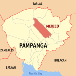 Location in the Philippines
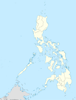
 Municipality of Mexico
Coordinates: 15°04′N 120°43′E / 15.067°N 120.717°ECoordinates: 15°04′N 120°43′E / 15.067°N 120.717°E Country  Philippines
Region Central Luzon (Region III) Province Pampanga District 3rd District Founded 1860 Barangays 43 Government - Mayor Teddy C. Tumang Area - Total 117.41 km2 (45.3 sq mi) Population (2007) - Total 141,298 - Density 1,203.5/km2 (3,116.9/sq mi) Time zone PST (UTC+8) ZIP code 2021 Income class 1st class Mexico is a 1st class municipality in the province of Pampanga, Philippines. According to the 2000 census, it has a population of 109,481 people in 20,382 households.
The town was named after Mexico, a country in North America after being confused with its native name "Masiku" which is often taken as "Elbowed" but according to most Kapampangan historians, it was named "Masiku" because "Siku" is an Old Kapampangan term for Chico or Sapodilla which grew richly in the town. It is a home of residential, commercial and recreational developments.
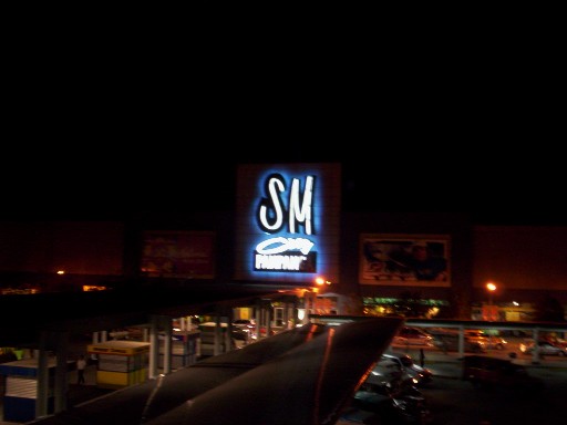
Population Census of Mexico, Pampanga Census Pop. Rate 1995 91,696 — 2000 109,481 3.88% 2007 141,298 3.58%  SM City Pampanga East Wing in Barangay Lagundi, Mexico, Pampanga
Contents
Barangays
Mexico is administratively subdivided into 43 barangays.
- Acli
- Anao
- Balas
- Buenavista
- Camuning
- Cawayan
- Concepcion
- Culubasa
- Divisoria
- Dolores (Piring)
- Eden
- Gandus
- Lagundi
- Laput
- Laug
- Masamat
- Masangsang (Sto. Cristo)
- Nueva Victoria
- Pandacaqui
- Pangatlan
- Panipuan
- Parian (Pob.)
- Sabanilla
- San Antonio
- San Carlos
- San Jose Malino
- San Jose Matulid
- San Juan
- San Lorenzo
- San Miguel
- San Nicolas
- San Pablo
- San Patricio
- San Rafael
- San Roque
- San Vicente
- Santa Cruz
- Santa Maria
- Santo Domingo
- Santo Rosario
- Sapang Maisac
- Suclaban
- Tangle (Tanglay)
History
In the 16th century, Mexico sat as a crossing point between the Áitâ Mag-Anchî and Áinu (Abûrlin) nations at the upper reaches of the Ábacan River and the international port cities of Bétis and Lúbao to the south. Upland products such as deerskins and beeswax became important commodities to the 16th century Japanese who made candles out of beeswax and samurai armours out of deerskins. Plying their goods down the Ábacan River, traders would slow down and dock at the place "where the river bends" (nung nú ya mákábákle ing ílug) before continuing their trip downstream. From there, the river is matúlid (straight) all the way to its mouth at Uáuâ. Enterprising merchants from the elsewhere in Luzon, and perhaps even from Japan and China formed a trading base at this natural checkpoint known as Makisíku or Másíku. Abacan river merges with Bulang Guinto (Golden bubble) creek before joining the Pampanga River.
In 1571, Mexico became the capital of the new colonial province of Pampanga at a place called Masangsang which meant Odiferous.[1] It was named "Mexico" due to the mispronounciation of the original name "Masiku" and in honour of the place where the first Spanish Governor General Miguel López de Legazpi founded his new life, Mexico City. Subsequently Toltecs, Aztecs and Mayans migrated here as by-product of the Manila Galleons' trade between New Spain and the East Indies. The capital of Pampanga was moved further downstream to Bacolor after the widespread Kapampangan Revolt of 1660 led by Don Francisco Maniago.
Culture
Mexico's town fiesta is celebrated every May 4 in honor of its patron saint, Santa Monica.
References
- ^ Conquistas
Books
- Gaspar de San Agustin, Conquistas de las Islas Filipinas 1565-1615, Translated by Luis Antonio Mañeru, 1st bilingual ed [Spanish and English], published by Pedro Galende, OSA: Intramuros, Manila, 1998
External links
- eK! - a Kapampangan journal of ideas
- Philippine Standard Geographic Code
- 1995 Philippine Census Information
- 2000 Philippine Census Information
- 2007 Philippine Census Information
Municipalities Component city Highly urbanized city (Administratively independent from the province, but grouped under Pampanga by the National Statistics Office)Largest municipalities in the Philippines Rank Municipalities Province Population (2007) Rank Municipality Province Population (2007) 1 Bacoor Cavite 441,197 11 Mabalacat Pampanga 203,307 2 Cainta Rizal 304,478 12 Silang Cavite 199,285 3 San Pedro Laguna 281,808 13 San Mateo Rizal 184,860 4 Taytay Rizal 262,485 14 Tanza Cavite 171,795 5 Imus Cavite 253,158 15 Marilao Bulacan 160,452 6 Binangonan Rizal 238,931 16 Lubao Pampanga 143,058 7 Rodriguez Rizal 223,594 17 Mexico Pampanga 141,298 8 General Trias Cavite 218,387 18 Jolo Sulu 140,307 9 Cabuyao Laguna 205,376 19 San Miguel Bulacan 138,839 10 Santa Maria Bulacan 205,258 20 Baliuag Bulacan 136,982 Philippines 2007 Census Categories:- Municipalities of Pampanga


Wikimedia Foundation. 2010.