- San Fernando, Bukidnon
Infobox Settlement
official_name = Municipality of San Fernando
other_name =
native_name =
nickname =
settlement_type =
motto =
imagesize = 180px
image_caption =
flag_size =
image_
seal_size = 150px
image_shield =
shield_size =
city_
citylogo_size =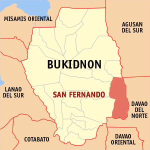
mapsize =
map_caption = Map ofBukidnon showing the location of San Fernando, Bukidnon
mapsize1 =
map_caption1 =
pushpin_
pushpin_label_position =
pushpin_map_caption =
pushpin_mapsize =
subdivision_type = Country
subdivision_name =Philippines
subdivision_type1 = Region
subdivision_name1 = Region X
subdivision_type2 = Province
subdivision_name2 = Bukidnon
subdivision_type3 = Districts
subdivision_name3 = 2nd District
subdivision_type4 =Barangays
subdivision_name4 = 24
government_type =
leader_title = Mayor
leader_name = Levi C. Edma, Sr.
leader_title1 = Vice Mayor
leader_name1 = Adam E. Santacera
established_title = Incorporated (town)
established_date =
established_title2 =
established_date2 =
established_title3 =
established_date3 =
area_magnitude =
unit_pref =
area_footnotes =
area_total_km2 = 638.63
area_land_km2 =
area_water_km2 =
area_total_sq_mi = 246.58
area_land_sq_mi =
area_water_sq_mi =
area_water_percent =
area_urban_km2 =
area_urban_sq_mi =
area_metro_km2 =
area_metro_sq_mi =
population_as_of = 2000
population_footnotes =
population_note =
population_total = 40, 165
population_density_km2 = 63
population_density_sq_mi = 163
population_metro =
population_density_metro_km2 =
population_density_metro_sq_mi =
population_urban =
population_density_urban_km2 =
population_density_urban_sq_mi =
timezone = PST
utc_offset = +8
timezone_DST =
utc_offset_DST =
latd= |latm= |lats= |latNS=
longd= |longm= |longs= |longEW=
elevation_footnotes =
elevation_m =
elevation_ft =
postal_code_type = ZIP code
postal_code = 8711
area_code = 88
blank_name =
blank_info =
blank1_name =
blank1_info =
website =
footnotes =San Fernando is a 2nd class municipality in the province of Bukidnon,
Philippines . According to the 2000 census, it has a population of 40,165 people in 8,112 households.History
The natives of
Bukidnon known as Tigwahanons and Matigsalugs were the original inhabitants of this area. They settled along the fertile river valleys of the Tigwa and Salug rivers. These people werenomadic by nature and subsisted mainly byhunting and eating forest products but they also maintained small plots ofcorn androot crops in places were they built their temporary shelters. They have afeudal type ofgovernment headed by a political chieftain known as “Datu ”, who also acted as their religious leader and armed forces chief.The municipality was formerly a district of the municipalities of Maramag, Dangcagan and Valencia City pursuant to Executive Order No. 347 of
Pres. Carlos P. Garcia datedJuly 29 ,1959 . During the reign of Gov. Teodoro Oblad and Cong. Cesar Fortich, a proposal was submitted to the defunct Congress for the creation of this district into municipality. OnJune 18 ,1966 , San Fernando was created into a municipality under R.A. 4789 and was named in honor of Fernando Damasco, the Father of former Gov. Catalino Damasco. The first set of government was installed at Barangay Namnam, approximately 48 kilometers away from Valencia City.The government
resettlement program forMindanao during the 1960s and 1970s attracted immigrants fromLuzon ,Visayas . The arrival of the migrants, attracted by the town’s rich agricultural potential, created moresettlement s in the area and contributed much in the development of the area. The original occupants of the town, the Tigwahanon and the Matigsalug, were then replaced by these lowlanders or “dumagats””. Only few natives remained in the lowland and the majority of them settled in the interior and mountainous areas of the municipality.On
July 27 ,1970 , however, the municipal council passed a resolution transferring the set of government from Namnam to Barangay Halapitan.Geography
Location
San Fernando is located in the southeast portion of the province of
Bukidnon . It is bounded in the north byMalaybalay City and Cabanglasan, in the east byDavao del Norte province, in the south byDavao City andNorth Cotabato province; and in the west by Quezon and Valencia City.The municipality’s
Poblacion is 31 kilometers from Valencia City and 71 kilometers from Malaybalay City.Topography
About eighty percent of the municipality’s area is mountainous. The Pantaron Mountain Range (Central Cordillera of Mindanao) forms part of the natural border between the municipality and the Davao provinces in the west while the Aga Mountains between Valencia City and Quezon.
The Tigwa River valley occupies the northern and central parts of the municipality while the Salug River valley is found in the southern part of the municipality.
Bodies of Water
The municipality has two major river systems: Tigwa River and Salug River. The Tigwa River is a tributary of the
Pulangi River , which empties into the Mindanao River in Cotabato. The Salug River is a tributary of theDavao River that empties intoDavao Gulf in the south.Demographics
The municipality has a total population of 48, 549 (2006, Projected) as of 2006 from 40, 165 in 2000 with 49 persons per square km.
Economy
The municipality is predominantly agricultural with
corn as the major product followed byrice andabaca .Rattan ,banana ,bamboo ,vegetables and root crops are also produced in the municipality.Politics and Administration
The municipality is administered by the Municipal Mayor together with the
Vice Mayor and theSangguniang Bayan . The mayor is the local chief executive officer of the municipality while the Sangguniang Bayan (or SB) serves as the local legislative arm as mandated by the Local Government Code of the Philippines of 1991. Under the Mayor’s Office are the following offices: Municipal Planning and Development Office, Municipal Civil Registrar’s Office, Municipal Engineering Office, Municipal Accounting Office, Municipal Treasurer’s Office, Municipal Assessor’s Office, Municipal Social Welfare and Development Office, Municipal Agriculture Office and Municipal Budget Office. These offices are mandated to deliver the basicsocial services to the inhabitants of the municipality.The Sangguniang Bayan is headed by the Vice Mayor, acting as its presiding officer, and seven (7) Sangguniang Bayan councilors. They formulate laws and ordinances relevant to the municipality.
San Fernando has twenty-four (25) barangays headed by a barangay captain together with seven Sangguniang Pambarangay members. 25 Barangays including Langasihan.
Transportation
The municipality has a total road network of 109.82 kilometers. The municipality can be reached by bus, jeepneys and habal-habal or motorcycles.
Barangays
San Fernando is politically subdivided into 24
barangay s.
* Bonacao
* Cabuling
* Kawayan
* Cayaga
* Dao
* Durian
* Iglugsad
* Kalagangan
* Kibongcog
* Little Baguio
* Nacabuklad
* Namnam
* Palacpacan
* Halapitan (Pob.)
* San Jose
* Santo Domingo
* Tugop
* Matupe
* Bulalang
* Candelaria
* Mabuhay (Kalagutay)
* Magkalungay
* Malayanan
* Sacramento ValleyExternal links
* [http://www.nscb.gov.ph/activestats/psgc/default.asp Philippine Standard Geographic Code]
* [http://www.census.gov.ph/data/census2007/index.html 2007 Official Philippine Census Information]
Wikimedia Foundation. 2010.