- Mindanao
-
Coordinates: 8°00′N 125°00′E / 8°N 125°E
Mindanao 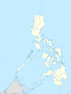
 Mindanao (Philippines)
Geography Location Southeast Asia Archipelago Philippine Archipelago Total islands 7,107 Major islands Mindanao, Sulu Area 97,530 km2 (37,657 sq mi) Area rank 19th Highest elevation 2,954 m (9,692 ft) Highest point Mount Apo Country Regions Caraga, Northern Mindanao, Zamboanga Peninsula, Davao Region, Autonomous Region of Muslim Mindanao (ARMM), SOCCSKSARGEN Provinces Agusan del Norte, Agusan del Sur, Basilan, Sulu, Tawi-tawi, Surigao del Norte, Surigao del Sur, Davao del Norte, Davao del Sur, Davao Oriental, Compostela Valley, Misamis Oriental, Misamis Occidental, Bukidnon, Lanao del Norte, Lanao del Sur, North Cotabato, South Cotabato, Saranggani, Sultan Kudarat, Maguindanao, Zamboanga del Norte, Zamboanga del Sur, Zamboanga Sibugay Largest city Davao City (pop. 1,363,337) Demographics Population 21,582,540 (as of 2007) Density 221.3 /km2 (573.2 /sq mi) Ethnic groups Bajao, Visayan (Butuanon, Surigaonon), Lumad (Kamayo, Manobo, Tasaday, T'boli), Moro (Maguindanao, Maranao), Zamboangueño Latino Mindanao /mɪndəˈnaʊ/ min-də-now is the second largest and easternmost island in the Philippines. It is also the name of one of the three island groups in the country, which consists of the island of Mindanao and smaller surrounding islands. The other two are Luzon and the Visayas. The island of Mindanao is called The Land of Promise. Mindanao is the only area of the Philippines with a significant Muslim presence.
Mindanao has been the site of a separatist movement by the Moro Islamic Liberation Front (MILF), caused by religious differences and widespread poverty. Fighting between MILF and Philippine forces has displaced over 100,000 people.
Contents
History
 An old Spanish map of Mindanao island
Mindanao is named after the Maguindanaons who constituted the largest Sultanate historically, and evidence from maps made during the 17th and 18th centuries suggests that the name was used to refer to the island by natives at the time. Evidence of human occupation dates back tens of thousands of years. In prehistoric times the Negrito people arrived. Sometime around 1500 BC Austronesian peoples spread throughout the Philippines and far beyond.
Islam first spread to the region during the 13th century through Arab traders from present-day Malaysia and Indonesia. Prior to this contact, the inhabitants of the area were primarily animists living in small autonomous communities.[1] The indigenous population was quickly converted and the first mosque in the Philippines was built in the mid 14th century in the town of Simunul.[1] The Philippine sultanates of Sulu and Maguindanao were subsequently in the 15th and 16th centuries, respectively. In the late 16th to early 17th centuries, the first contact with Spain occurred. By this time, Islam was well established in Mindanao and had started influencing groups as far north as present-day Manila on the island of Luzon.[1]
Upon the Spaniards' arrival to the Philippines, they were dismayed to find such a strong Muslim presence on the island, having just expelled the Moors from Spain after centuries of fighting. In fact, the name Moros (the Spanish word for "Moors") was given to the Muslim inhabitants by the Spanish.[1]
Today, the region is home to most of the country's Muslim or Moro populations, composed of many ethnic groups such as the Maranao and the Tausug, the Banguingui (users of the vinta), as well as the collective group of indigenous tribes known as the Lumad.
Geography
Mindanao is the second largest island in the country at 94,630 square kilometers, and is the eighth most populous island in the world. The island of Mindanao is larger than 125 countries worldwide, including the Netherlands, Austria, Portugal, Czech Republic, Hungary, Taiwan and Ireland. The island is mountainous, and is home to Mount Apo, the highest mountain in the country. Mindanao is surrounded by seas: the Sulu Sea to the west,[2] the Philippine Sea to the east, and the Celebes Sea to the south. Of all the islands of the Philippines, Mindanao and Borneo shows the greatest variety of physiographic development. High, rugged, faulted mountains; almost isolated volcanic peaks; high rolling plateaus; and broad, level, swampy plains are found there.
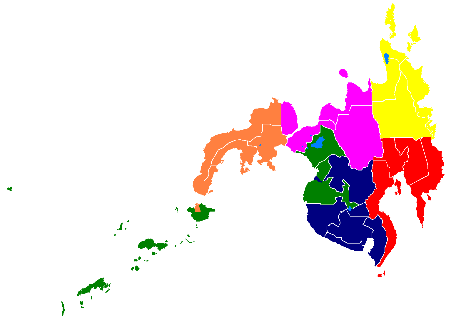
The island group of Mindanao encompasses Mindanao island itself and the Sulu Archipelago to the southwest. The island group is divided into six regions, which are further subdivided into 26 provinces.
Mountains and plateaus
 Mt. Apo, the highest peak in the Philippines.
The mountains of Mindanao can be conveniently grouped into five ranges, including both complex structural mountains and volcanoes. The structural mountains on the extreme eastern and western portions of the island show broad exposures of Mesozoic rock with ultrabasic rocks at the surface in many places along the east coast. Surface rock in other areas of the island is mainly Tertiary and Quaternary volcanic or sedimentary.
Paralleling the east coast, from Bilas Point in Surigao del Norte to Cape Agustin in southeast Davao, is a range of complex mountains known in their northern portion as the Diwata Mountains. This range is low and rolling in its central portion. A proposed road connecting Bislig on the east coast with the Agusan River would pass through a ten-mile (16 km) broad saddle across the mountains at a maximum elevation of less than 250 meters, while the existing east-west road from Lianga, 30 miles (48 km) north of Bislig, reaches a maximum elevation of only 450 meters. The Diwata Mountains, north of these low points, are considerably higher and more rugged, reaching an elevation of 2,012 meters in Mount Hilonghilong, 17 miles (27 km) northeast of Butuan City. The southern portion of this east coast range is broader and even more rugged than the northern section. In eastern Davao, several peaks rise above 2,500 meters and one unnamed mountain rises to 2,810 meters.
The east-facing coastal regions of Davao and Surigao del Sur are marked by a series of small coastal lowlands separated from each other by rugged forelands which extend to the water’s edge. Offshore are numerous coral reefs and tiny islets. This remote and forbidding coast is made doubly difficult to access during the months from October to March by the heavy surf driven before the northeast trade winds. A few miles offshore is found the Mindanao or Philippine Deep. This ocean trench, reaching measured depths of 35,400 feet (10,800 m), marks one of the greatest depths known on the earth’s surface.
A second north-south range extends along the western borders of Agusan and Davao provinces from Camiguin Island in the north to Tinaca Point in the south. This range is mainly structural in origin, but it also contains at least three active volcano peaks. In the central and northern portions of this range, there are several peaks between 2,000 and 2,500 meters, and here the belt of mountains is about 30 miles (48 km) across. West of Davao City are two active volcanoes: Mount Talomo at 2,693 meters and Mount Apo at 2,954 meters. Mount Apo is the highest point in the Philippines and dominates the skyline. South of Mount Apo, this central mountain belt is somewhat lower than it is to the north, with peaks averaging only 1,100 to 1,800 meters.
In Western Mindanao, a range of complex structural mountains forms the long, hand-like Zamboanga Peninsula. These mountains, reaching heights of only 1,200 meters, are not as high as the other structural belts in Mindanao. In addition, there are several places in the Zamboanga Mountains where small inter-mountain basins have been created, with some potential for future agricultural development. The northeastern end of this range is marked by the twin peaks of the now extinct volcano, Mount Malindang, which rise splendidly behind Ozamis City to a height of 2,425 meters. Mount Dapia is the highest mountain in the Zamboanga Peninsula, reaching a height of 2,617 meters (8,586 ft). Meanwhile, Batorampon Point is the highest mountain of the southernmost end of the peninsula, reaching a height of only 1,335 meters (4,380 ft); it is located in the boundary of Zamboanga City.
A series of volcanic mountains is found near Lake Lanao in a broad arc through Lanao del Sur, northern Cotabato and western Bukidnon provinces. At least six of the twenty odd peaks in this area are active and several are very impressive as they stand in semi-isolation. The Butig Peaks, with their four crater lakes, are easily seen from Cotabato. Mount Ragang, an active volcano cone reaching 2,815 meters, is the most isolated, while the greatest height is reached by Mount Kitanglad at 2,896 meters.
In southwestern Cotabato, still another range of volcanic mountains is found, this time paralleling the coast. These mountains have a maximum extent of 110 miles (180 km) from northwest to southeast and measure some 30 miles (48 km) across. One of the well-known mountains here is Mount Parker, whose almost circular crater lake measures a mile and a quarter in diameter and lies 300 meters below its 2,040-meter summit. Mount Matutum is a protected area and is considered as one of the major landmarks of South Cotabato Province.
A second important physiographic division of Mindanao is the series of upland plateaus in Bukidnon and Lanao del Sur provinces. These plateaus are rather extensive and almost surround several volcanoes in this area. The plateaus are made up of basaltic lava flows interbedded with ash and volcanic tuff. Near their edges, the plateaus are cut by deep canyons, and at several points spectacular waterfalls drop to the narrow coastal plain. These falls hold considerable promise for development of hydroelectric energy. Indeed, one such site at Maria Cristina Falls has already become a major producer. Because the rolling plateaus lie at an elevation averaging 700 meters above sea level, they offer relief from the often oppressive heat of the coastal lowlands. Lake Lanao occupies the major portion of one such plateau in Lanao del Sur. This largest lake on Mindanao and second in the country is roughly triangular in shape with an 18-mile (29 km)-long base. Having a surface at 780 meters above sea level, and being rimmed on the east, south and west by series of peaks reaching 2,300 meters, the lake provides a scenic grandeur and pleasant temperature seldom equaled in the country.[citation needed] Marawi City, at the northern tip of the lake, is bisected by the Agus River, which feeds the Maria Cristina Falls.
Another of Mindanao’s spectacular waterfall sites is located in Malabang, 15 miles (24 km) south of Lake Lanao. Here the Jose Abad Santos Falls present one of the nation’s scenic wonders at the gateway to a 200-hectare national park development.
The Limunsudan Falls, with an approximate height of 800 ft (240 m), is the highest waterfalls in the Philippines; it is located at Iligan City.
Plains
Mindanao contains two large inland lowland areas, the valleys of the Agusan and Mindanao rivers in Agusan and Cotabato Provinces, respectively. There is some indication that the Agusan Valley occupies a broad syncline between the central mountains and the east-coast mountains. This valley measures 110 miles (180 km) from south to north and varies from 20 to 30 miles (48 km) in width. 35 miles (56 km) north of the head of Davao Gulf lies the watershed between the Agusan and the tributaries of the Libuganon River, which flows to the Gulf. The elevation of this divide is well under 200 meters, indicating the almost continuous nature of the lowland from the Mindanao Sea on the north to the Davao Gulf.
The Mindanao River and its main tributaries, the Catisan and the Pulangi, form a valley with a maximum length of 120 miles (190 km) and a width which varies from 12 miles (19 km) at the river mouth to about 60 miles (97 km) in central Cotabato. The southern extensions of this Cotabato Valley extend uninterrupted across a 350-meter watershed from Illana Bay on the northwest to Sarangani Bay on the southeast.
Other lowlands of a coastal nature are to be found in various parts of Mindanao. Many of these are tiny isolated pockets, as along the northwest coast of Zamboanga. In other areas such as the Davao Plain, these coastal lowlands are as much as ten miles (16 km) wide and several times that length.
From Dipolog City eastward along the northern coast of Mindanao almost to Butuan City extends a rolling coastal plain of varying width. In Misamis Occidental, the now dormant Mount Malindang has created a lowland averaging eight miles (13 km) in width. Shallow Panquil Bay divides this province from Lanao del Norte, and is bordered by low-lying, poorly drained lowlands and extensive mangroves. In Misamis Oriental, the plain is narrower and in places almost pinched out by rugged forelands which reach to the sea. East of Cagayan de Oro, a rugged peninsula extends well into the Mindanao Sea.
Culture
Main article: Culture of the PhilippinesMain articles: Music of the Philippines and KulintangCebuano is spoken by the majority of people in Mindanao. Cebuano is generally the native language in most regions, except for the Muslim areas on the west coast and among the hill tribes.
The Spanish-based creole, Chavacano is the official language of Zamboanga City and the lingua franca in other parts of Zamboanga Peninsula and Basilan Province. The dialect Zamboangueño Chavacano is one of the six dialects of Chavacano (whose native speakers are known as the Zamboangueño Latino). Zamboangueño Chavacano is also spoken as a minority language in some other points of Mindanao such as Davao and Cotabato. Zamboangueño Chavacano is also recognized as minority language in Sabah, Malaysia as well.
There are still a number of Spanish speakers, most of them elderly members of mestizo families.
Christians form the majority, with 63% of the population; Muslims are 32% of the population (mostly on the southern part of the island); 5% are affiliated with other religions.[citation needed] The native Maguindanaon and other native Muslim or non-Muslim groups of Mindanao have a culture that is different from the main cultures of the Southern Philippines.
Political divisions
Main article: Political divisions of MindanaoThe island group of Mindanao is an arbitrary grouping of islands in the Southern Philippines which encompasses six administrative regions.[3] These regions are further subdivided into 26 provinces, of which only four are not on Mindanao island itself. Some of the areas are semi-autonomous Muslim areas. The island group includes the Sulu Archipelago to the southwest, which consists of the major islands of Basilan, Jolo, and Tawi-Tawi, plus outlying islands in other areas such as Camiguin, Dinagat, Siargao, Samal.
The six regions are:
Administrative region Area (km²) Population 2007 Census Population density (/km²) Zamboanga Peninsula 16,823 3,230,094 192.0 Northern Mindanao 20,132 3,952,437 196.3 Davao Region 20,244 4,156,653 205.3 SOCCSKSARGEN 22,466 3,829,081 170.4 Caraga 21,471 2,293,480 106.8 ARMM* 26,974 4,120,795 152.8 Mindanao (Group) 128,110 21,582,540 168.4 Mindanao is composed of 26 provinces, each headed by a Governor. A governor is elected by popular vote and can serve a maximum of three terms consisting of three years each.
As for representation in the Philippine Congress, Mindanao is represented by 46 Congressmen elected in the same manner as the governors.
Zamboanga Peninsula (Region IX)
 Zamboanga City skyline
Zamboanga Peninsula / Western Mindanao is a peninsula and an administrative region in the Philippines. The regional center is Zamboanga City. Its provinces are:
- Zamboanga del Norte
- Zamboanga del Sur
- Zamboanga Sibugay
- City of Isabela part of Basilan but out of its jurisdiction.
Northern Mindanao (Region X)
 Aerial view of Cagayan de Oro City.
Northern Mindanao is an all occupying the north-central part of Mindanao island, and the island-province of Camiguin. The regional center is Cagayan de Oro City. The provinces and cities are:
Davao Region (Region XI)
 Aerial view of Davao City.
Davao Region / Southern Mindanao is one of the regions of the Philippines, located on the southeastern portion of Mindanao. The regional center is Davao City. Its provinces are:
SOCCSKSARGEN Region (Region XII)
 Aerial view of General Santos City.
SOCCSKSARGEN is a region of the Philippines, located in central Mindanao. The regional center is Koronadal City. The name is an acronym that stands for the region's four provinces and one of its cities:
- South Cotabato with General Santos City
- Cotabato
- Cotabato City is a part of Maguindanao but a part of SOCCSKSARGEN Region
- Sultan Kudarat
- Sarangani Province
Caraga Region (Region XIII)
 Butuan City.
Caraga is an administrative region of the Philippines, on the northeastern portion of the island of Mindanao. The regional center is Butuan City. It's provinces are:
Autonomous Region for Muslim Mindanao (ARMM Region)
Autonomous Region in Muslim Mindanao (abbreviated ARMM) is the region, located in the Mindanao island group of the Philippines, that is composed of predominantly Muslim provinces. The regional center is . It's provinces are:
- Basilan except the City of Isabela
- Lanao del Sur
- Maguindanao except the City of Cotabato
- Sulu
- Tawi-Tawi
See also
- Caesarea Karoli
- Geography of the Philippines
- Rido, blood feuds
- Bangsamoro
- Moro people
- Islam in the Philippines
- Lumad
- Majapahit
- Srivijaya
- Sultanate of Sulu
- Sultanate of Maguindanao
- Regions of the Philippines
- Provinces of the Philippines
- 2006 Central Mindanao bombings
- July 2009 Mindanao bombings
Notes
References
- ^ a b c d Koerner, Brendan I. (28 January 2005). "How Islam got to the Philippines". Slate. http://www.slate.com/id/2112795/. Retrieved 4 October 2009.
- ^ C.Michael Hogan. 2011. Sulu Sea. Encyclopedia of Earth. Eds. P.Saundry & C.J.Cleveland. Washington DC
- ^ List of Regions in the Philippines
External links
- Mindanao Radio Stations Online
- Mindanao Magazine
- Moro Friends Community
- The Catalyst for Countryside Development
- Mindanao News
- Online Mindanao
- Taboan Mindanao
Categories:- Islands of the Philippines
- Mindanao
- Super Regions of the Philippines


Wikimedia Foundation. 2010.