- Masbate
-
"Masbate" redirects here. For other uses, see Masbate (disambiguation).
Masbate — Province — 
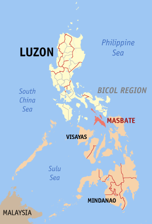
SealMap of the Philippines with Masbate highlighted
Coordinates: 12°10′N 123°35′E / 12.167°N 123.583°ECoordinates: 12°10′N 123°35′E / 12.167°N 123.583°E Country  Philippines
Region Bicol Region (Region V) Founded March 10, 1917 Capital Masbate City Government - Governor Rizalina L. Seachon-Lañete (NPC) Area - Total 4,151.8 km2 (1,603 sq mi) Area rank 33rd out of 80 Population (2007) - Total 768,939 - Rank 30th out of 80 - Density 185.2/km2 (479.7/sq mi) - Density rank 42nd out of 80 Divisions - Independent cities 0 - Component cities 1 - Municipalities 20 - Barangays 550 - Districts 1st to 3rd districts of Masbate Time zone PHT (UTC+8) ZIP Code 5400-5421 Spoken languages Bikol, Masbateño, Tagalog, English Masbate (Tagalog pronunciation: [masˈbate]) is an island province of the Philippines located in the Bicol Region. Its capital is Masbate City and consists of three major islands: Masbate, Ticao and Burias.
Contents
History
When Captain Luis Enriquez de Guzman anchored on the shores of Masbate in 1569, he found tiny settlements spread along the coasts engaged in flourishing trade with China. Chinese traders visited Masbate and founded small settlements during the Shri-Vijayan and Madjapahit periods. Ruins of cave-like dwellings resembling "kiva" (possibly built by Indians who accompanied the Chinese traders), were found along the coasts of Aroroy, Palanas, and Masbate. Porcelain jars dating back to the 10th century were excavated at Kalanay (Aroroy) in the 1930s.
Historical accounts show that the Christianization of the Bicol Region actually began in Masbate in 1569:
Father Alonso Jimenez was the first missionary to the islands of Masbate, Burias, Leyte and Samar. Then he went to Ibalon (Bicol) in Camarines Province, where he resided many years, and made many religious incursions into Albay Province and Sorsogon Province. Fray Jimenez is considered the apostle of the island of Masbate
In December 1600 Dutch Commander Admiral Oliver van Noorth, sought refuge at San Jacinto Harbor after his fleet lost to the Spanish Armada in Manila. He was later engaged in a fierce clash with Limahong's fleet at Canlibas-Matabao passage.
At the height of the Galleon Trade, Mobo contributed first class lumber for the construction of galleons, making it the center of trade in the province and was the capital of the province in the early part of the Spanish occupation
In 1864, Masbate was declared a separate province from Albay. Guiom was made the capital while Ticao became a commandancia-politicio-militar. Shortly before the declaration of Philippine independence by President Emilio Aguinaldo, the town of Masbate was established as the provincial capital.
The Americans came to Masbate in 1900 to extend their pacification campaign. In December 1908, Masbate was annexed to theprovince of Sorsogon. A bill declaring Masbate as independent province was approved on February 1, 1922.
As early as 1906, the Masbate representative made the proposal to the United States Congress to grant the Philippines independence.
The first Japanese elements arrived in Masbate the dawn of January 7, 1942 from Legazpi. They landed in several places without facing opposition- the province was too stunned to mount any resistance.
The Japanese occupation reduced Masbate to total economic shambles. Economic activities were limited to fishing, buying/selling, or stealing. Food production ground to a halt. Camote, pakol, banana blossoms, pith, and even such obscure fruits like barobo were used as food substitutes. Lakad-bulan served as cigarette, tea or coffee. Barter transaction prevailed. For lack of nutrition and sanitation, many people succumbed to beri-beri or malaria. Lice and ticks infestations spared only a lucky few.
Dr. Mateo S. Pecson, who was governor of the province, having refused to cooperate with the Japanese, evacuated the provincial government to Guiom, a command post used by the guerrillas. Pecson was eventually arrested by the Japanese and incarcerated in Cavite. He managed to escape; he later joined the guerrilla movement in Central Luzon.
In 1944, Provincial Board Member Atty. Jose L. Almario was conscripted by the Japanese to govern the province. During the Liberation, he was arrested by the guerrillias and charged with collaboration. He was exonerated and saved from set execution by a letter from General MacArthur.
Dr. Emilio B. Espinosa, the lone house representative of Masbate, fought against a congressional bill authorizing the conscription of Filipinos into the service of Imperial Japan and for this he was detained in Fort Santiago.
When Masbate was formally liberated by joint Filipino and American soldiers on April 3, 1945, Pecson was sent to Masbate by President Osmeña to organize the civil government, Pecson took the reins of government on May 11, 1945..
Geography
The island of Masbate lies at the center of the Philippine archipelago between latitudes 11o43’ north and 123o09’ east and 124o5’ east. It is bounded on the north by Burias and Ticao Pass, east by San Bernardino Strait, south by the Visayan Sea, and west by the Sibuyan Sea. Relative to mainland Bicol, the province faces the southwestern coasts of Camarines Sur, Albay, and Sorsogon.
The general surface configuration of the province ranges from slightly undulating to rolling and from hilly to mountainous. In each island, the rugged topography is concentrated in the northeastern portion and gradually recedes to blunt hills and rolling areas in the south, southeast, and southwest.
Masbate island is considered as the center of the Philippines.
Demography
The Province of Masbate has a population of 768,939 in the 2007 Census of Population with 397,524 registered voters (as of 2004). It consists of 20 municipalities, 1 component city and 550 barangays.
Language
The people speak predominantly Bikol, Masbateño (or Minasbate, the dialect unique to the province), some Visayan languages with a unique mixture of Tagalog and some shades of Hiligaynon (sometimes also known as Ilonggo). According to the 2000 Philippines Population Census, 27% of the population of Masbate province speak Cebuano. In Burias Island, they speak Bicol similarly as the people of Camarines Sur, due to the island’s proximity to the Bicol mainland. The people generally speak fluent English and Filipino.
Religion
The Diocese of Masbate was created on March 23, 1968, separating it from the Diocese of Sorsogon. It comprises then, and now, the civil province of Masbate with its 121 islands including the two larger ones Burias and Ticao. It is now a suffragan of the Archdiocese of Caceres. Its titular patron is St. Anthony of Padua.
Masbate's land area of 7000 square kilometers holds a population of 598,813 of which 85 per cent are Catholics. Devotional practices such as the rosary, novenas to saints, and other religious manifestations as processions, the misa de gallo and Holy Week traditional activities are still very much part of the way of life of most parishioners.
The Diocese of Masbate cannot truly boast, at this point, of great achievements in terms of programs and projects. But it has started to initiate various church programs spearheaded by the Diocesan Commissions on Religious Formation, Social Action and Liturgy, to start on its mission to steer its parishioners towards maturity in the Christian faith. This is done through catechesis, spiritual retreats, seminars, youth encounters, and the like.
There are a total 22 parishes in the Diocese of Masbate, ministered to by 43 priests and 11 religious sisters. It has 1 minor seminary, 4 pastoral centers, 3 elementary schools, 6 high schools, 1 college and 7 kindergarten schools. And among its faith communities are 20 BEC's 46 neo-catechumenal communities. 11 mandated organizations and 3 charismatic groups.
Literacy
The Province of Masbate's literacy rate is 95.90%. Its educational institutions consist of effective public and private schools like the Masbate National Comprehensive High School in Masbate City that has three campuses - (MNCHS-Bolo Campus, MNCHS-Main Campus, MNCHS-Annex Campus) and the state-supportedDr. Emilio B. Espinosa Sr. Memorial State College of Agriculture and Technology, Osmeña Colleges, Masbate Colleges, Holy Name Academy,a catholic institution run by the Augustinian Recollect Sisters in Palanas Masbate and Lucio Atabay Memorial Elementary School ( formerly, Nipa Elementary School ) in Nipa, Palanas, Masbate and many elementary, secondary schools and colleges.
Infrastructure
Being an agricultural province, Masbate remains a net importer of consumer and industrial products. The supply of goods came from Metro Manila, Cebu, Panay and Bicol Provinces. Construction materials, particularly cement are sometimes sourced as a far as Iligan City in Mindanao.
To meet the needs of growth and expansion of the industries, the infrastructure in most part of the province is continually being upgraded. These include the road and its network, transportation, communication facilities, seaports, airport and other support services.
The road and road network, particularly in Mainland Masbate, has kept on improving annually. Road structure is mostly cemented and/or asphalted and timber bridges have been concreted.
As a result, transportation sector has been a growing industry. Aircon minibuses and jeepneys are regularly plying in the two road sections of Mainland Masbate, which made transportation available round-the-clock for the need of the people and industries.
Economy and Mining
The Province of Masbate is classified as a first class province.
Masbate is endowed with rich natural resources. In line with its agriculture are other industries such as large farming, livestock and poultry raising. Along its coastal areas, fishing industry predominates. Agricultural lands are planted with rice, corn, rootcrops and coconut.
Masbate ranks second only to Bukidnon in raising cattle. Abouth 70% of these are sold to Metro Manila and other provinces in Luzon.Farming is the main source of livelihood. Copra is the leading product, followed by corn, rice and rootcrops. Fishing is a major industry along the coast.
The province is one of the richest in the country in terms of mineral resources that include gold, copper, silver, iron, manganese and chromite. A foreign-owned company, CGA mining limited, is operating a gold mine in Aroroy, Masbate. At least 4 million tons of ore per year are being processed by CGA. The mine has provided tax and fees to both local and national governments. With the millions of ore/rock being processed, after extracting the about 1% gold in the ore, millions of tons of tailings in the form of ground rocks or sediments and water plus some contaminants, are directed by the mine to her engineered tailings storage facility closed to mangrove and populated areas.
In case a strong earthquake of magnitude say 7.8 occur, there is no 100% assurance that the tailings storage facility embankment/dam of this mine in Aroroy can hold the millions tons of contaminated slurry . According to the designer, the embankment may suffer deformation during earthquake and it is not specified the extent of deformation. Deformation may result to escape of millions tons of contaminated sediments from this Dam.
Manufacturing firms are in the copra industry, handicrafts, furnituremaking and fish processing.
The province is surrounded with rich fishing areas where all kinds of commercial species of fish teemed in great abundance.
Rich minerals are found in the province. Masbate is described by geologists as a province sitting on a "pot of gold". Other minerals found in the area are manganese, copper, silver, iron, chromite, limestone, guano, and carbon.
Cottage industry is likewise another source of livelihood. They are: furniture and cabinet making, ceramics, garments, handicrafts and metalcrafts.
Note; the longest road in the philippines can only be found in San Pasual because in 50 years of constructing the road from San Pascual to claveria and the feather roads of barangays until now 20 percent only are finished.
Education
Major institutions of higher learning in the province include the Dr. Emilio B. Espinosa Sr. Memorial State College of Agriculture and Technology (DEBESMSCAT) in Mandaon and in Masbate City, Osmeña Colleges, Masbate Colleges, Liceo de Masbate and Southern Bicol College. Masbate also has national schools in Cataingan, Placer, San Jacinto, Mandaon, Mobo, etc. and Masbate city itself.
Political divisions
Masbate is subdivided into 20 municipalities and 1 city.
City/Municipality No. of
BarangaysArea
(km²)Population
(2007)Mayor
(2007–2010)Aroroy 41 62,635 Enrico Capinig Baleno 24 169.20 21,639 Gracia Mingoy-Llamado Balud 32 223.63 31,484 Clemente A. Arguelles, Jr Batuan 14 12,585 Charlie Yuson III Cataingan 36 224.21 48,827 Wilton Kho Cawayan 37 302.68 59,658 Ramon B. Abinuman Claveria 22 40,336 Eduardo M. Andueza Dimasalang 20 114.28 22,723 Demphna Du-Naga Esperanza 20 16,834 Mac John C. Seachon Mandaon 26 34,401 Emily Estipona Hao 
Masbate City 30 119.70 81,585 Socrates M. Tuazon Milagros 27 48,185 Dr. Natividad Magbalon Mobo 29 32,740 Atty. Percival D. Castillo Monreal 11 21,693 Ben G. Espiloy Palanas 24 24,830 Silvestre L. Alvarez, Sr. Pio V. Corpuz 18 79.99 22,102 Diomedes C. Amaroto Placer 35 48,469 Joshur Judd S. Lanete II San Fernando 26 19,179 Maria Vida Espinosa-Bravo San Jacinto 21 26,508 Hon. Leny Arcenas San Pascual 22 41,736 Zacarina A. Lazaro Uson 36 43,825 Felepe U. Sanchez Masbate is also divided into 3 congressional districts, with the following representatives.
- 1st District - Narciso Bravo Jr. (KAMPI)
- 2nd District - Antonio Kho (Lakas-NUCD)
- 3rd District - Scott Davies Lanete (NPC)
See also
Notes
External links
Municipalities Aroroy • Baleno • Balud • Batuan • Cataingan • Cawayan • Claveria • Dimasalang • Esperanza • Mandaon • Milagros • Mobo • Monreal • Palanas • Pio V. Corpuz • Placer • San Fernando • San Jacinto • San Pascual • UsonComponent city Categories:

Wikimedia Foundation. 2010.