- Clarkridge, Arkansas
-
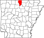
Clarkridge, Arkansas — Unincorporated community — Clarkridge's position in Arkansas.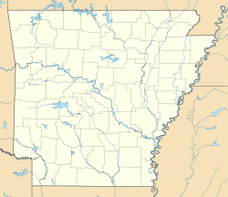
 Clarkridge, Arkansas
Coordinates: 36°28′40″N 92°21′5″W / 36.47778°N 92.35139°WCoordinates: 36°28′40″N 92°21′5″W / 36.47778°N 92.35139°W Country  United States
State  Arkansas
County Baxter Township Pigeon Elevation 265 m (869 ft) Time zone Central (CST) (UTC-6) - Summer (DST) CDT (UTC-5) GNIS feature ID 76623 U.S. Geological Survey Geographic Names Information System: Clarkridge, Arkansas Clarkridge, Arkansas (formerly Clark Ridge) is an unincorporated community in Baxter County, Arkansas, United States.[1] The community is located near the end of Arkansas Highway 201 near the Missouri state line.[2] Clarkridge has one post office, three churches and one resort on Norfork Lake. Clarkridge has a Volunteer Fire Department.
References
- ^ "Feature Detail Report for: Clarkridge, Arkansas." USGS. U.S. Geological Survey Geographic Names Information System: Clarkridge, Arkansas Retrieved March 14, 2011.
- ^ DeLorme. Arkansas Atlas and Gazetteer (Map) (Second ed.). Section 25.
Municipalities and communities of Baxter County, Arkansas County seat: Mountain Home Cities Cotter | Gassville | Lakeview | Mountain Home | Norfork | Salesville
Towns CDP Unincorporated
communitiesArkana | Buffalo City | Buford | Clarkridge | Gamaliel | Henderson | Hopewell | Monkey Run | Old Joe
Footnotes ‡This populated place also has portions in an adjacent county or counties
Categories:- Populated places in Baxter County, Arkansas
- Unincorporated communities in Arkansas
- Arkansas geography stubs


Wikimedia Foundation. 2010.