- Long Island Motor Parkway
-
"LIMP" redirects here. For other uses, see Limp (disambiguation).Long Island Motor Parkway
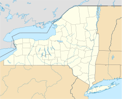

Location: Roughly Alley Pond and Cunningham Parks, bet. Winchester Blvd. and Clearview Expressway, bet. 73rd Ave. and Peck Ave., Queens, New York Coordinates: 40°44′13″N 73°45′35″W / 40.73694°N 73.75972°WCoordinates: 40°44′13″N 73°45′35″W / 40.73694°N 73.75972°W Area: 10 acres (4.0 ha) Built: 1908 Architect: Williams, E.G.; Brown, E.H. Governing body: Local NRHP Reference#: 02000301[1] Added to NRHP: April 01, 2002  Map showing the Long Island Motor Parkway (in purple). Click to expand
The Long Island Motor Parkway (LIMP), also known as the Vanderbilt Parkway and Motor Parkway, was the first roadway designed for automobile use only.[2] It was privately built by William Kissam Vanderbilt with overpasses and bridges to remove intersections. It opened in 1908 as a toll road and closed in 1938 when it was taken over by the State of New York in lieu of back taxes. Parts of the parkway survive today in sections of other roadways and as a bicycle trail in Queens, New York.
Contents
History
William Kissam Vanderbilt II, the great-grandson of Cornelius Vanderbilt, was an auto-racing enthusiast and created the Vanderbilt Cup, the first major road racing competition, in 1904. However, the race came under fire after a series of accidents and, with the goal of building a safe road that was also free of the dust churned up by horses, he floated a company to build a roadway that would serve only motor cars. Primarily so that he could organize his Vanderbilt Cup race safely, he floated a company to construct a roadway where the race could be run safely. The resulting Long Island Motor Parkway, with its banked turns, guard rails, reinforced concrete tarmac, and controlled access, was the first limited-access roadway opened in the world.[3]
The turnpike was originally planned to stretch for 70 miles (113 km) as a route in and out of New York City as far as Riverhead, the county seat of Suffolk County, New York, and point of division for the north and south forks of Long Island. Eventually, though, only 45 miles (from Queens in New York City to Lake Ronkonkoma, New York) were actually constructed, at a cost of $6 million.[3] Construction began in June 1908 (a year after the Bronx River Parkway), and a 10-mile-long section of the parkway opened (as far as modern Bethpage) to traffic in October 1908, making it the first superhighway put into use. The Long Island Motor Parkway was a toll road. By 1911, the road was extended to Lake Ronkonkoma.
The parkway, the first roadway designed exclusively for automobile use, was the first concrete highway built in the United States and it was the first to use overpasses and bridges to eliminate intersections.[4][dead link]
Roadway design advances of the 1920s rendered the Motor Parkway obsolete less than 20 years after construction. At the same time Robert Moses was planning the Northern State Parkway. Initially the owners and some Long Island officials wanted the Motor Parkway integrated into the state parkway system, despite its narrow roadway and steep bridges not meeting new standards. Robert Moses was against the idea, stating that the parkway would need significant reconstruction. The completion of the Northern State Parkway signaled the end for the Motor Parkway. In 1938 the parkway was sold to New York State for $80,000 in lieu of backtaxes and closed.[3] Most of the Motor Parkway in Queens (west of Winchester Boulevard, whose widening destroyed an overpass) exists as a bicycle trail from Cunningham Park to Alley Pond Park, part of the Brooklyn-Queens Greenway.
The Nassau County roadway has been developed, or turned into a right of way for Long Island Power Authority transmission lines. Part of the parkway in Suffolk County exists as Suffolk County Route 67 and parts of the parkway were incorporated into the Meadowbrook State Parkway.[3]
Racing
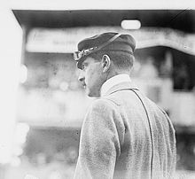 William K Vanderbilt II
An impetus for the building of the road was to provide a graded, banked and grade-separated highway suitable for racing. Vanderbilt had operated his Vanderbilt Cup races over local roads in Nassau County during the first decade of the 20th century, but the killing of two spectators and the injury of many others showed the need to eliminate racing on residential streets.
The parkway hosted races on its first open portion in 1908 and on the full road in 1909 and 1910, but another accident in the latter year, killing four with additional injuries, caused the New York Legislature to ban racing except on race tracks, ending the parkway's career as a racing road.
Access
As an early limited access road, access was only provided at a small number of toll booths, joined to local roads by short connector roads. Traffic could turn left between the parkway and connectors, thus crossing oncoming traffic, so it was not a freeway. The following access points existed:
 Historical marker, Huntington, LI
- Nassau Boulevard (now Long Island Expressway) west of Francis Lewis Boulevard
- Hillside Avenue - Springfield Boulevard south of 77th Avenue
- Great Neck - Lakeville Road south of Lake Road
- Roslyn - Roslyn Road south of Barnyard Lane
- Mineola - Jericho Turnpike at Rudolph Drive
- Garden City - Clinton Road at Vanderbilt Court
- Meadow Brook - Merrick Avenue north of Stewart Avenue
- Massapequa - Hicksville Road (New York State Route 107) south of Avoca Avenue
- Bethpage - Round Swamp Road south of Old Bethpage Road
- Huntington - Broad Hollow Road north of Spagnoli Road
- Deer Park - Deer Park Road (New York State Route 231)
- East Commack - Commack Spur along Harned Road to Jericho Turnpike (New York State Route 25)
- Brentwood - Washington Avenue
- Ronkonkoma - Rosevale Avenue
When the parkway opened, the toll was set at $2. Over the years, the toll declined to $1.50 in 1912, $1 in 1917, and 40c in 1938. The first six toll houses were designed by John Russell Pope, the architect who designed the rotunda in the American Museum of Natural History and the Jefferson Memorial.[3] The toll houses were designed to include living space for the toll collectors so that toll could be collected at all hours. One toll house now houses the Garden City Chamber of Commerce in Garden City, Long Island.
Remaining portions
County Route 67
Location: Huntington – Lake Ronkonkoma Length: 14.51 mi[5] (23.35 km)  Remnant of Long Island Motor Parkway circa 2008 at Springfield Boulevard in Queens, looking East
Most of the road from Queens to Western Suffolk County has been obliterated by homes, other roads and structures, or has returned to nature. Some parts can be traced, while some bridges still exist.
The western portion in Queens was reopened a few months after closure as a bicycle path from Cunningham Park to Alley Pond Park. This part of the old highway starts at Francis Lewis Boulevard in Cunningham Park near a park connecting Cunningham Park with Kissena Park. There is access to Peck Avenue just after the start of the bike path. It now runs parallel with 199 Street and crosses a bridge over 73 Avenue. It now swings back to Francis Lewis Boulevard, crossing it on a bridge. It continues through the park, crossing the Clearview Expressway on another bridge, and then Hollis Hills Terrace on a fourth bridge before leaving the park. There is now access to 209 and 210 Streets in Hollis Hills. It now goes through a wooded corridor, soon crossing over Bell Boulevard on a bridge, and provides access to 220 Street just east of Bell Boulevard. After crossing Springfield Boulevard on another bridge, there is access to Cloverdale Boulevard. The old highway now enters Alley Pond Park, crosses under the Grand Central Parkway, and provides access to Union Turnpike before ending at Union Turnpike and Winchester Boulevard at the park's boundary.
The highway itself survives as a continuous county road, Vanderbilt Motor Parkway (County Route 67), from Half Hollow Road in Dix Hills to its original end in Ronkonkoma, just a few blocks short of the lake. Signage along the way also identifies it variously as Vanderbilt Parkway and Motor Parkway. From Half Hollow Road, it goes northeast to NYS Route 231, Deer Park Avenue. It starts to parallel the Northern State Parkway and intersects with County Route 4, Commack Road, in Commack. It crosses the Saktigos State Parkway (access northbound only) and heads south to I-495, the Long Island Expressway. It now heads east, parallel with the expressway (there is access to and from the LIE), and then crosses it, heading southeast to NYS Route 111, Joshua's Path. It then heads north, crossing the LIE again at Exit 57, and then curves to the east and crosses NYS Route 454, Veterans Memorial Highway. It heads east, crosses Old Nichols and Terry Roads, and then goes northeast, ending at Rosedale Avenue, County Route 93, in Ronkonkoma, close to the lake.
Though not a limited access road since 1938, most of the road was recognizable into the 1970s, while new intersections continued to be cut through it. In the approximate middle of the road in and around Islandia, New York, office construction and other commercial building has widened the road and made it appear a typical highway. Nonetheless, other portions, especially at the western and eastern ends of the surviving road, can be enjoyed for greenery, graded and banked turns, and rolling hills, albeit at considerably less than racecar speeds.
Preservation
In 2005, two historians / preservationists[who?] voiced their intentions of preserving what undeveloped portions of original Long Island Motor Parkway pavement remain for use as part of a historical hike/bike trail (minus the existing Queens trail segment), submitting a formal proposal to Nassau County, Suffolk County, the Long Island Power Authority (which uses several portions of the old right-of-way to run powerlines) and the State of New York. Work is expected to begin on the idea at some point in the near future, and most of that work will be carried out by the New York State Department of Transportation.
The most prominent remaining toll house can be found in Garden City. [6] Once located at the juncture of Clinton Road and Vanderbilt Court, it was moved in 1989 to its current location in the heart of the village at 230 Seventh Street. It now serves as the headquarters of the Garden City Chamber of Commerce.[7]
Anniversaries
In 2008, the Long Island Motor Parkway celebrated its 100th Anniversary. On October 30, 2011, a centennial event will mark the 100th Anniversary of the completion of the parkway's Lake Ronkonkoma section. Led by the winner of the 1909 and 1910 Vanderbilt Cup races, a parade of automobiles made prior to 1948 will go from Dix Hills to Lake Ronkonkoma. [8]
References
- ^ "National Register Information System". National Register of Historic Places. National Park Service. 2009-03-13. http://nrhp.focus.nps.gov/natreg/docs/All_Data.html.
- ^ Kroplick, Howard; Al Velocchi (2009). Long Island Motor Parkway, The. Charleston SC: Acadia Publishing: Images of America. p. 7. ISBN 0738557935.
- ^ a b c d e Patton, Phil (October 9, 2008). "A 100-Year-Old Dream: A Road Just for Cars". The New York Times. http://www.nytimes.com/2008/10/12/automobiles/12LIMP.html?partner=permalink&exprod=permalink. Retrieved September 16, 2009.
- ^ http://www.newsday.com/community/guide/lihistory/ny-history-hs701a,0,6567870.story
- ^ "Region 3 Inventory Listing". New York State Department of Transportation. March 2, 2009. https://www.nysdot.gov/divisions/engineering/technical-services/highway-data-services/inventory-listing. Retrieved February 4, 2010.
- ^ Garden City Historical Society Garden City Toll Lodge
- ^ Giardino, Carisa (June 23, 2011). "Efforts Underway to Preserve Long Island Motor Parkway". Garden City Patch. http://gardencity.patch.com/articles/efforts-underway-to-preserve-long-island-motor-parkway. Retrieved August 26, 2011.
- ^ Sachem Patch, October 21, 2011 Motor Parkway Parade reschedued for October 30
External links
- Long Island Motor Parkway (VanderbiltCupRaces.com)
- Long Island Vanderbilt Parkway (NYCROADS.com)
- Long Island Motor Parkway Preservation Society (Sam Berliner III)
- Long Island Motor Parkway (Arrt's Arrchives)
- "The Age of the Auto: Sportsman William K. Vanderbilt II's cup race paves the way to the future," by Sylvia Adcock (Newsday—Long Island; Our Story)
- Art's Long Island Motor Parkway Site (Art K.)
- LIMP (wikimapia.org map showing route and remnants of the parkway)
Parkways on Long Island, New York East-west North-south Formerly proposed U.S. National Register of Historic Places Topics Lists by states Alabama • Alaska • Arizona • Arkansas • California • Colorado • Connecticut • Delaware • Florida • Georgia • Hawaii • Idaho • Illinois • Indiana • Iowa • Kansas • Kentucky • Louisiana • Maine • Maryland • Massachusetts • Michigan • Minnesota • Mississippi • Missouri • Montana • Nebraska • Nevada • New Hampshire • New Jersey • New Mexico • New York • North Carolina • North Dakota • Ohio • Oklahoma • Oregon • Pennsylvania • Rhode Island • South Carolina • South Dakota • Tennessee • Texas • Utah • Vermont • Virginia • Washington • West Virginia • Wisconsin • WyomingLists by territories Lists by associated states Other  Category:National Register of Historic Places •
  Portal:National Register of Historic PlacesCategories:
- Historic districts in New York
- Bike paths in New York
- Buildings and structures in Queens
- County routes in Suffolk County, New York
- Demolished highways in the United States
- Long Island highways
- Parks in Queens
- Parkways in New York City
- Roads on the National Register of Historic Places in New York
- Transportation in Nassau County, New York
- Transportation in Queens
- Vanderbilt Cup


Wikimedia Foundation. 2010.