- Old Leake
-
Coordinates: 53°01′55″N 0°05′50″E / 53.03192400°N 0.097341388°E
Old Leake 
St Marys church, Old Leake
 Old Leake
Old Leake shown within LincolnshirePopulation 1,803 (2001) OS grid reference TF407503 District Boston (borough) Shire county Lincolnshire Region East Midlands Country England Sovereign state United Kingdom Post town Boston Postcode district PE22 Dialling code 01205 Police Lincolnshire Fire Lincolnshire Ambulance East Midlands EU Parliament East Midlands UK Parliament Boston and Skegness List of places: UK • England • Lincolnshire Old Leake is a village and civil parish in Lincolnshire, England, around 8 miles (13 km) north-east of Boston, on the A52 road between Leverton and Wrangle at the junction of the B1184 (from Sibsey). The parish includes areas known as The Gride to the north west, Leake Commonside and Lade Bank to the north, and Leake Hurns End to the south east.
Contents
Geography
It is one of eighteen parishes which, together with Boston, form the Borough of Boston in the county of Lincolnshire, England. The local government has been arranged in this way since the reorganization of April 1, 1974, which resulted from the Local Government Act 1972. This parish forms part of the Old Leake and Wrangle electoral ward.
Hitherto, the parish had formed part of Boston Rural District, in the Parts of Holland. Holland was one of the three divisions (formally known as parts) of the traditional county of Lincolnshire. Since the Local Government Act of 1888, Holland had been in most respects, a county in itself.
Amenities
The parish church is a grade I listed building dedicated to Saint Mary, and dating from the 12th century, with the chancel being restored in 1875 by Temple Moore. There is a 15th century Alms Box [1] The lychgate is grade II listed and may have been built by Temple Moore.[2]
Howsams Mill is a grade II listed building in Leake Commonside built in 1859.[3]
 Water Tower at Old Leake
On the edge of a field sits a water tower of Swedish design which was put up with planning permission in 1966.
The village pubs are the White Hart on Church Road and the Bricklayer's Arms on Wainfleet Road (A52). The Giles School is on Church End. This is a secondary modern school with a sixth form. There is a National Health Service doctors' surgery, Old Leake Medical Centre, which takes patients from Old Leake and the surrounding villages, including Eastville, Wrangle, Friskney, Leverton, Butterwick, Freiston, Sibsey and Fishtoft.
Lade Bank Pumping Station
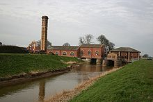 Lade Bank Pumping Station
Lade Bank lock was built on the Hobhole Drain in 1805 by John Rennie and 1867 the Lade Bank pumping station was built of red and yellow brick. Originally a lock of four cutwaters and two abutments with grooves and fixings for lock gates. In 1867 an engine house and pumping station with tall chimney were built above. The engine house contained six boilers to raise the steam to operate the two pumps. It was replaced by a modern station of 1936 also partly built on the original lock bases.[4]
Population
Population of Leake Civil Parish Year 1801 1811 1821 1831 1841 1851 1881 1891 Population[5] 911 922 1,417 1,744 1,859 2,062 2,120 1,962 Population of Old Leake Civil Parish Year 1901 1911 1921 1931 1941 1961 2001 Population[6] 1,387 1,340 1,438 1,492 1,614 1,557 1,803 Destinations from Old Leake 
Stickney, Stickford, Horncastle New Leake, Toynton St Peter, Spilsby Friskney, Wainfleet, Skegness Sibsey, Frithville, Langriville 
Wrangle  Old Leake

Boston, Frampton, Swineshead Leverton, Benington, Freiston Shore References
- ^ "St Marys Old Leake". National Heritage List for England. English Heritage. http://list.english-heritage.org.uk/resultsingle.aspx?uid=1147754. Retrieved 8 July 2011.
- ^ "Lychgate". National Heritage List for England. English Heritage. http://list.english-heritage.org.uk/resultsingle.aspx?uid=1062034. Retrieved 1 September 2011.
- ^ "Howsams Mill". National Heritage List for England. English Heritage. http://list.english-heritage.org.uk/resultsingle.aspx?uid=1360499. Retrieved 1 September 2011.
- ^ "Lade Bank Pumping Station". National Heritage List for England. English Heritage. http://list.english-heritage.org.uk/resultsingle.aspx?uid=1360501. Retrieved 8 July 2011.
- ^ "Vision of Britain". http://www.visionofbritain.org.uk/data_theme_page.jsp?u_id=10429869&c_id=10001043&data_theme=T_POP. Retrieved 1 September 2011.
- ^ "Vision of Britain". http://www.visionofbritain.org.uk/data_cube_page.jsp?data_theme=T_POP&data_cube=N_TOT_POP&u_id=10462850&c_id=10001043&add=N. Retrieved 1 September 2011.
External links
Categories:- Villages in Lincolnshire
- Civil parishes in Lincolnshire


Wikimedia Foundation. 2010.