- Crackington Haven
-
Coordinates: 50°44′40″N 4°38′16″W / 50.74454°N 4.63774°W
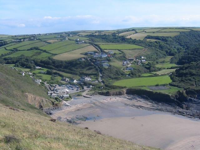
 Crackington Haven viewed from Penkenna Point looking south in 2003.
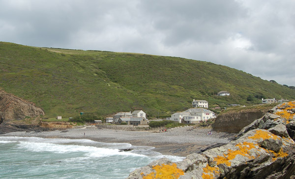
 Crackington Haven seen across the beach in 2005.
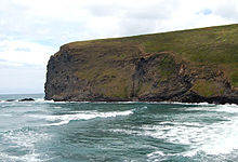 Penkenna Point in 2005 showing the folded strata of the rock.
Crackington Haven (Cornish: Porthkrag) is a coastal village in Cornwall, United Kingdom. It is located in the civil parish of St Gennys at grid reference SX140972 at the head of a cove on the Atlantic coast. The village is seven miles (11 km) south-southwest of Bude and four miles (7 km) north-northeast of Boscastle[1].
Middle Crackington and Higher Crackington are associated settlements. They are situated on the hill southeast of Crackington Haven, half-a-mile and one mile distant respectively.
Crackington Haven is popular with campers, walkers and geology students. The surrounding cliffs are well-known for their visible folded sedimentary rock formations. The village gives its name to the Crackington formation, a sequence of Carboniferous sandstones and grey shales[2].
The village has a small shop, two tea rooms and a pub called the Coombe Barton Inn in a building which was originally the house of the manager of a local slate quarry.
Crackington Haven has a stony foreshore but a sandy beach is revealed at low water. There are toilet facilities near the beach and lifeguard cover in the summer.
Immediately north of the beach is Pencarrow Point and a few hundred yards south is Cambeak headland. One mile south of Crackington Haven, High Cliff rises to 735 feet (224 m) with a sheer drop to the rocky foreshore[3]. It is Cornwall's highest cliff and is also classified as southern Britain's highest sheer-drop cliff (Great Hangman in Devon has a cliff face of 820 feet (250 m).[4]
History
Until the nineteenth century, Crackington Haven was a small port similar to many others on the north coast of Cornwall. Limestone and coal were imported and slate and other local produce were exported. After the railways reached the district in 1893 the village could be reached more easily (from the North Cornwall Railway station at Otterham) so holidaymaking became more common.
Crackington Haven was badly affected in 2004 by the flood that damaged several other villages, including Boscastle. The road bridge across the stream, several homes and pub were damaged by floodwater. (See also Boscastle flood of 2004)
References
- ^ Ordnance Survey: Landranger map sheet 190 Bude & Clovelly ISBN 9780319231456
- ^ [1] Dartmoor National Park Authority information sheet
- ^ Ordnance Survey: Landranger map sheet 190 Bude & Clovelly ISBN 9780319231456
- ^ Richards, Mark (1974) Walking the North Cornwall Coastal Footpath. Gloucester: Thornhill Press ISBN 0-904110-12-5
External links
 Media related to Crackington Haven at Wikimedia Commons
Geography of Cornwall Cornwall Portal Unitary authorities Major settlements Bodmin • Bude • Callington • Camborne • Camelford • Falmouth • Fowey • Hayle • Helston • Launceston • Liskeard • Looe • Lostwithiel • Marazion • Newlyn • Newquay • Padstow • Par • Penryn • Penzance • Porthleven • Redruth • Saltash • St Austell • St Blazey • St Columb Major • St Ives • St Just-in-Penwith • St Mawes • Stratton • Torpoint • Truro • Wadebridge
See also: Civil parishes in CornwallRivers Topics History • Status debate • Flag • Culture • Places • People • The Duchy • Diocese • Politics • Hundreds/shires • Places of interest • full list...Categories:- Beaches of Cornwall
- Geography of Cornwall
- Villages in Cornwall

Wikimedia Foundation. 2010.