- Dogdyke
-
Coordinates: 53°04′58″N 0°11′39″W / 53.082705°N 0.19421943°W
Dogdyke 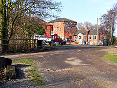
Dogdyke Marina (former railway station)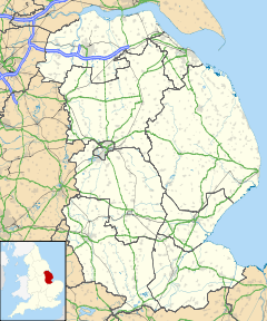
 Dogdyke
Dogdyke shown within LincolnshireOS grid reference TF210554 District East Lindsey Shire county Lincolnshire Region East Midlands Country England Sovereign state United Kingdom Postcode district LN4 Police Lincolnshire Fire Lincolnshire Ambulance East Midlands EU Parliament East Midlands UK Parliament Louth and Horncastle List of places: UK • England • Lincolnshire Dogdyke is a hamlet near Tattershall, Lincolnshire, England. It is at the confluence of the Rivers Bain and Witham, and close to where the River Slea joins the Witham.[1]
Nearby settlements are the hamlets of Chapel Hill, Tattershall Bridge and Hawthorn Hill.[1]
Dogdyke is part of the civil Parish of Dogdyke with Chapel Hill[2] within the district of North Kesteven[3] and is within the ecclesiastical parish of Billinghay. The civil parish also includes nearby Tattershall Bridge, where the A153 crosses the Witham.[1]
Contents
History
The placename and settlement dates from the 13th century from the Old English for the dyke where docks grow.[4] It was formerly situated on the east bank of the River Witham in Coningsby parish where it grew around the terminus of a ferry.[4]
The Chapel of Saint Nicholas was located in Dogdyke in the 14th Century, and was mentioned in 1342. It has long since vanished and its location has not been found.[5] Dogdyke appears as Dokedyke in the 14th century,[6] and fell within the ancient wapentake of Langoe.
Dogdyke County Primary School opened in 1871 as the Tattershall Bridge School, and was later administered by the Billinghay United District School Board, formed in 1879, when it became known as Billinghay Tattershall Bridge Board School. New premises were built in 1881 and it became Dogdyke council school in 1903, and Dogdyke County School abt 1947. It was reorganised as a primary School in 1963 and finally closed in July 1981.[7]
Drainage
The first drainage pump at Dogdyke was built in 1796 and was wind-powered. It was replaced in 1856 by the Dogdyke Pumping Station which was steam, and later diesel driven.[8] It is a local attraction.[says who?]
Dogdyke falls within the drainage area of the Witham Third District Internal Drainage Board.[9]
Chapel Hill, on the opposite bank of the Witham, falls within the drainage area of the Witham First District Internal Drainage Board.[10]
Businesses
Dogdyke has two public houses, a caravan park and a marina.
See also
References
- ^ a b c OSGB (03/04/2006). 122: Skegness & Horncastle (Map). 1:50000. OS Landranger (C2 ed.). ISBN 9780319229392. http://leisure.ordnancesurvey.co.uk/products/paper-maps/paper-maps-ordnance-survey-great-britain/paper-maps-ordnance-survey-great-britain-os-landranger-map/skegness-and-horncastle/pid-9780319229392.
TF205550 - ^ "Parish Council details". http://parishes.lincolnshire.gov.uk/DogdykeincChapelHill/.
- ^ "Map of parish boundaries in NKDC". http://www.n-kesteven.gov.uk/upload/public/attachments/1106/parish_cluster_map_generic1.pdf.
- ^ a b "Lincs to the Past". Lincolnshire Archives. http://www.lincstothepast.com/Settlement-of-Dogdyke/239591.record?pt=S. Retrieved 9 May 2011.
- ^ "Lincs to the Past". Lincolnshire Archives. http://www.lincstothepast.com/Unlocated-medieval-chapel-of-St-Nicholas-at-Dogdyke/239610.record?pt=S. Retrieved 9 May 2011.
- ^ Maxwell Lyte, H. C., ed (1914). Calendar of Close Rolls, Richard II. 1: 1377-1381. http://www.british-history.ac.uk/report.aspx?compid=107020&strquery=dogdyke.
- ^ "Lincs to the Past". Lincolnshire Archives. http://www.lincstothepast.com/DOGDYKE-COUNTY-PRIMARY-SCHOOL/886214.record?pt=S. Retrieved 9 May 2011.
- ^ "Lincs to the Past". Lincolnshire Archives. http://www.lincstothepast.com/Dog-Dyke-Pumping-Station--Tatterhsall/226863.record?pt=S. Retrieved 9 May 2011.
- ^ "Witham Third District IDB". http://www.witham-3rd-idb.gov.uk.
- ^ "Witham First District IDB". http://www.witham-1st-idb.gov.uk/.
External links
- GenUKi site, with description of parish and summary of boundary changes
- Pumping station preservation society
- Folk legend: The werewolf of Dogdyke
Categories:- Lincolnshire
- Villages in Lincolnshire
- Civil parishes in Lincolnshire
- Hamlets in England
- Lincolnshire geography stubs
- ^ a b c OSGB (03/04/2006). 122: Skegness & Horncastle (Map). 1:50000. OS Landranger (C2 ed.). ISBN 9780319229392. http://leisure.ordnancesurvey.co.uk/products/paper-maps/paper-maps-ordnance-survey-great-britain/paper-maps-ordnance-survey-great-britain-os-landranger-map/skegness-and-horncastle/pid-9780319229392.


Wikimedia Foundation. 2010.