Charlie Lake (British Columbia)

Charlie Lake (British Columbia)
Charlie Lake
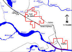
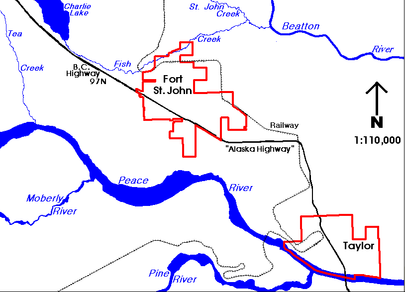
Charlie Lake situated north-west of Fort St. John
Coordinates 56°19′29″N 120°58′31″W / 56.32484°N 120.97536°W / 56.32484; -120.97536 (Charlie Lake)Coordinates: 56°19′29″N 120°58′31″W / 56.32484°N 120.97536°W / 56.32484; -120.97536 (Charlie Lake)
Primary inflows Stoddart Creek
Primary outflows Stoddart Creek
Basin countries Canada
Max. length 13 kilometers (8.1 mi)[1]
Max. width 3 kilometers (1.9 mi)
Surface elevation 700 meters (2,300 ft)
Settlements Charlie Lake

Charlie Lake is a lake in north-eastern British Columbia, Canada, situated 8 kilometers (5.0 mi) west from Fort St. John, along the Alaska Highway. The lake provides the water supply for the city of Fort St. John.[2] The Charlie Lake Formation, a stratigraphical unit of the Western Canadian Sedimentary Basin is named for the lake.

Geography

The lake is situated at an elevation of 700 meters (2,300 ft). It is formed along the Stoddart Creek, a right tributary of the Beatton River, itself a major tributary of the Peace River.

Two parks are established on the shores of the lake, Charlie Lake Provincial Park[1] on the west shore, and Beatton Provincial Park on the east shore. The settlement of Charlie Lake lies at the southern tip of the lake.

References


Wikimedia Foundation. 2010.

Игры ⚽ Поможем сделать НИР

Look at other dictionaries:

  • Charlie Lake, British Columbia — …   Wikipedia

  • Charlie Lake Cave — Lage: bei Fort St. John in British Columbia, Kanada Geographische Lage …   Deutsch Wikipedia

  • British Columbia — Colombie Britannique Britisch Kolumbien Wappen Flagge (Details) …   Deutsch Wikipedia

  • Charlie Lake Provincial Park — is a provincial park in British Columbia, Canada, established on the western shore of Charlie Lake. It is roughly 92 hectares in size. Contents 1 History and conservation 2 Location 3 Size …   Wikipedia

  • British Columbia — Colombie Britannique 54° N 125° W / 54, 125 …   Wikipédia en Français

  • British Columbia Ambulance Service — Infobox company company name = British Columbia Ambulance Service company company type = Crown Agency foundation = July 1, 1974 location = British Columbia, Canada num employees = 3,200 (2006) revenue = $252 Million industry = Emergency Medical… …   Wikipedia

  • British Columbia Highway 29 — Infobox road province=BC type=Hwy route=29 maint= length km= length round= length ref= established= direction a= starting terminus= junction= direction b= ending terminus= previous type=Hwy previous route=28 next type=Hwy next route=30Highway 29 …   Wikipedia

  • Highway 97 (British Columbia) — British Columbia Highway 97 ist die längste, durchgehende Fernstraße in der Provinz British Columbia im Westen von Kanada. Highway 97 südlich von Fort Nelson Inhaltsverzeichnis 1 …   Deutsch Wikipedia

  • Pouce Coupe, British Columbia — Infobox Settlement official name = Pouce Coupe other name = native name = nickname = settlement type = Village motto = imagesize = image caption = Pouce Coupe town hall flag size = image seal size = image shield = Pouce Coupe BC logo.jpg shield… …   Wikipedia

  • Bella Coola, British Columbia — Bella Coola is a community of approximately 600 at the western extremity of the Bella Coola valley. Bella Coola usually refers to the entire valley, encompassing the settlements of Bella Coola proper ( the townsite ), Lower Bella Coola,… …   Wikipedia

Share the article and excerpts

Direct link
Do a right-click on the link above
and select “Copy Link”