- Coast Range (EPA ecoregion)
-
This article is about the ecoregion designated by the EPA. For the mountains in California, see California Coast Ranges. For the mountains in Oregon, see Oregon Coast Range. For the mountains in Washington, see Olympic Mountains.
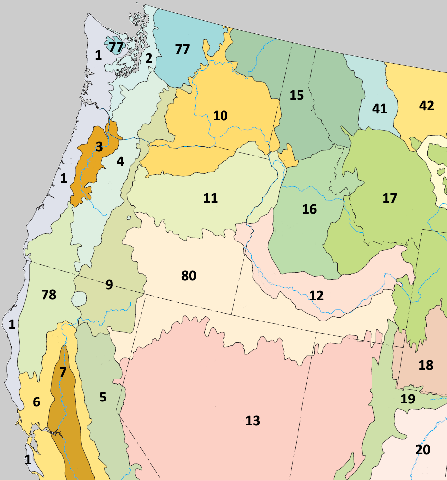
 Level III ecoregions in the Pacific Northwest. The Coast Range (1) borders the Puget Lowland (2), Willamette Valley (3), Southern and Central California Chaparral and Oak Woodlands (6), North Cascades (77), and Klamath Mountains (78) ecoregions.
The Coast Range ecoregion is a Level III ecoregion designated by the Environmental Protection Agency (EPA) in the U.S. states of Washington, Oregon, and California. It stretches along the Pacific Coast from the tip of the Olympic Peninsula in the north to the San Francisco Bay in the south, including Grays Harbor, Willapa Bay, and the Long Beach Peninsula in Washington, the entire length of the Oregon Coast, and the Northern California Coast. Named for the Coast Range mountains, it encompasses the lower elevations of the Olympic Mountains, the Oregon Coast Range, the Californian North Coast Ranges, and surrounding lowlands.[1][2]
The low mountains of the ecoregion are covered by highly productive, rain-drenched evergreen forests that are home to the three tallest conifer species in the world: Coast redwood,[3] Coast Douglas-fir,[4] and Sitka spruce.[5] Historically, Sitka spruce forests dominated the fog-shrouded coast, while a mosaic of western redcedar, western hemlock, and seral Douglas-fir blanketed the inland areas. Today, Douglas-fir plantations are prevalent on the intensively logged and managed landscape. Lithology influences land management strategies; slopes underlain by sedimentary rock are more susceptible to failure following clearcutting and road building than those underlain by volcanic rock.[1]
The Coast Range ecoregion has been subdivided into nine Level IV ecoregions. Level IV mapping is not yet complete in California, and the information below includes only the sections in Washington and Oregon.
Contents
Level IV ecoregions
 Level IV ecoregions in the Coast Range in Washington and Oregon. Contiguous areas in California have not been mapped yet. (Full map).
Coastal Lowlands (1a)
The Coastal Lowlands ecoregion contains beaches, sand dunes and spits, and low marine terraces below 400 feet (122 m) elevation. Characteristic features include wet forests, shallow freshwater lakes, estuarine marshes, and low-gradient, meandering tannic streams and rivers. Residential, commercial, and recreational developments are expanding in the coastal corridor. Many wetlands in the floodplains of the region's streams have been drained and converted into pastures for dairy farms, and associated stream degradation has occurred. Mature forests in the region are dominated by a canopy of Sitka spruce, western hemlock, and Douglas-fir, with salal, sword fern, vine maple, and Oregon grape in the shrub layer. The riparian zone supports red alder, western redcedar, and bigleaf maple with an understory of salmonberry; California bay-laurel is common in the south. Estuaries and coastal wetlands may feature Baltic rush, Lyngby’s sedge, tufted hairgrass, Pacific silverleaf, and seaside arrowgrass with shore pine, sweet gale, and Hooker’s willow. Stabilized dunes support shore pine over salal, rhododendron, and evergreen blueberry, with dune wildrye, Chilean strawberry, and dune bentgrass. Soil textures range from silty clay loam to sandy loam. The region covers 633 square miles (1,639 km2) in Oregon and 353 square miles (914 km2) in Washington, with the largest contiguous areas found near Grays Harbor, Willapa Bay, the mouth of the Columbia River, Tillamook Bay, and along the southern Oregon Coast. Public lands include the Grays Harbor, Willapa, Nestucca Bay, Siletz Bay, and Bandon Marsh National Wildlife Refuges, the Oregon Dunes National Recreation Area, and numerous state parks.[1][2]
Coastal Uplands (1b)
The Coastal Uplands ecoregion includes the headlands, high marine terraces, hills, and low mountains surrounding the Coastal Lowlands, with medium to high gradient tannic streams. Elevation varies from 400 to 2500 feet (120 to 760 m). The climate is marine-influenced with an extended winter rainy season and minimal seasonal temperature extremes. Abundant fog during the summer dry season reduces vegetation moisture stress. The Uplands region roughly corresponds with the historic distribution of Sitka spruce. After extensive logging, most of the Sitka spruce is gone, and today the forests are dominated by Douglas-fir and western hemlock, with a shrub layer of salal, sword fern, vine maple, Oregon grape, rhododendron, and evergreen blueberry. Wetter slopes and riparian areas feature red alder, bigleaf maple, and western redcedar, with a salmonberry and currant understory. The headlands are covered by grasslands. The region is nearly three times the size of the Coastal Lowlands, covering 1,431 square miles (3,706 km2) in Washington and 1,117 square miles (2,893 km2) in Oregon. Public lands include the Drift Creek Wilderness, the Siuslaw National Forest, and the Lewis and Clark and Cape Meares national wildlife refuges. California has not been mapped yet.[1][2]
Low Olympics (1c)
The Low Olympics ecoregion contains foothills and lower mountains of the Olympic Range, with U-shaped valleys and high gradient streams. It rises to an elevation of approximately 4,000 feet (1,219 m). Higher areas were glaciated. Copious precipitation (up to 200 inches (5,080 mm) a year) supports a lush, epiphyte-rich rainforest of western hemlock, western red cedar, and Douglas-fir, with Pacific silver fir at higher elevations. Riparian zones support red alder and bigleaf maple forests. Much of the region is in the third rotation of logging, including land within the Olympic National Forest. However, a portion of the region lies within Olympic National Park and contains ancient forests with extremely high biomass. The region covers 1,685 square miles (4,364 km2), entirely on the Olympic Peninsula of Washington. The higher elevations of the Olympic Mountains to the east are designated as part of the North Cascades ecoregion.[2]
Volcanics (1d)
The Volcanics ecoregion consists of steeply sloping mountains and capes underlain by fractured basaltic rocks. Elevation generally varies from 600 to 4100 feet (180 to 1250 m), although in some places the volcanic rock extends down to sea level. The region is marked by columnar and pillow basalt outcrops. Its mountains may have been offshore seamounts engulfed by continental sediments about 200 million years ago. High gradient, cascading streams and rivers occur, and the basaltic substrate preserves summer flows that are more consistent than streams on the sedimentary rocks in surrounding ecoregions. The streams still support runs of spring chinook salmon and summer steelhead. The region's Douglas-fir plantations are heavily logged. Mature forests consist of Douglas-fir, western hemlock, salal, sword fern, vine maple, Oregon grape, and rhododendron. Wetter slopes and riparian areas may support western redcedar, bigleaf maple, red alder, salmonberry, and oxalis. Grassy coastal headlands and mountaintop balds feature Roemer’s fescue, thin bentgrass, California oatgrass, and diverse forbs. This large but disjunct ecoregion covers 2,043 square miles (5,291 km2) in Oregon and 1,542 square miles (3,994 km2) in Washington, including parts of the Olympic and Siuslaw National Forests and the Cummins Creek and Rock Creek Wildernesses, as well as higher elevations in the Cape Meares National Wildlife Refuge. California has not been mapped yet.[1][2]
Outwash (1e)
The Outwash ecoregion is a gently sloping fan of glacial outwash material that forms a series of undulating terraces and plateaus. Elevation varies from 20 to 1000 feet (6 to 300 m). The region lies outside the zone of marine influence, and its medium gradient streams and rivers have lower summer flow than most other parts of the Coast Range. Mature forest types include Douglas-fir, western hemlock, red alder, bigleaf maple, and western red cedar, but today the region is largely dominated by industrial timber plantations. It is the smallest of the Coast Range subregions, covering 354 square miles (917 km2) in Grays Harbor County north of Aberdeen, Washington.[2]
Willapa Hills (1f)
The Willapa Hills ecoregion (named for the Willapa Hills) consists of low, rolling hills and low, gently sloping mountains with medium gradient streams and rivers. It rises to an elevation of approximately 1,300 feet (396 m). This region has a lower drainage density than other upland areas in the Coast Range. Logging is relatively easy and less expensive in this accessible terrain, and industrial timberland has almost completely replaced the historic forests. When disturbed, the silt- and clay-textured soils are easily eroded, thereby degrading stream quality. The vegetation consists of Douglas-fir and western hemlock forests, with sword fern, vine maple, salal, Oregon grape, and rhododendron shrub layer. Wetter slopes and riparian areas support red alder, western redcedar, bigleaf maple, salmonberry, and oxalis. Large herds of Roosevelt elk winter in the region. The region covers 1,277 square miles (3,307 km2) in southwestern Washington and 751 square miles (1,945 km2) in northwestern Oregon, inland from the coast.[1][2]
Mid-Coastal Sedimentary (1g)
The mountainous Mid-Coastal Sedimentary ecoregion lies outside of the coastal fog zone and is typically underlain by massive beds of sandstone and siltstone. Elevation varies from 300 to 3000 feet (90 to 900 m). The region is more rugged than the geologically similar Willapa Hills. Its Douglas-fir forests are intensively managed for logging, and the slopes are prone to failure when disturbed, particularly south of the Siuslaw River. Stream sedimentation is higher than in the Volcanics ecoregion. The mature forest consists of Douglas-fir and western hemlock, with salal, sword fern, vine maple, Oregon grape, and rhododendron; tanoak may be found on drier slopes to the south. Wetter slopes and riparian areas support bigleaf maple, western redcedar, grand fir, red alder, salmonberry, and oxalis, with California bay-laurel in the south. This is the largest of the Coast Range subregions, covering 3,739 square miles (9,684 km2) in the Central and Southern Oregon Coast Range.[1][2]
Southern Oregon Coastal Mountains (1h)
The Southern Oregon Coastal Mountains ecoregion is a geologically and botanically diverse ecoregion that is a transition zone between the Coast Range and the Siskiyou Mountains, which form part of the Klamath Mountains ecoregion to the east. Rising to an elevation of approximately 4,000 feet (1,219 m), this region has the climate of the Coast Range but the varied lithology of the higher, more dissected Siskiyou Mountains, underlain by Jurassic sandstone, metamorphosed sediments, granite, and serpentinite. Distributions of northern and southern vegetation blend together here and species diversity is high. Douglas-fir, western hemlock, tanoak, Port Orford cedar, and western redcedar are present, along with salal, sword fern, vine maple, Oregon grape, rhododendron, California bay-laurel, bigleaf maple, grand fir, red alder, salmonberry, and oxalis. The region covers 692 square miles (1,792 km2) in a remote area of Curry County in southwestern Oregon containing the Sixes and Elk River drainages. It includes Grassy Knob Wilderness within the Siskiyou National Forest.[1][2]
Redwood Zone (1i)
The low mountains of the Redwood Zone ecoregion lie entirely within the coastal fog zone. Elevation varies from 50 to 1800 feet (15 to 550 m). Historically, unbroken redwood forests moderated the local climate by trapping the coastal fog and producing shade. Remnants of unlogged redwood forest still survive east of Brookings, Oregon. Today, the region is characteristically covered by a mixed forest of coast redwood and Douglas-fir, with a shrub layer of vine maple, rhododendron, sword fern, and oxalis. The region covers 31 square miles (80 km2) in the far southwestern corner of Oregon. Larger sections in northwestern California have not been mapped yet.[1][2]
Gallery
Flora
-

Coast Douglas-fir, Oregon's state tree
-

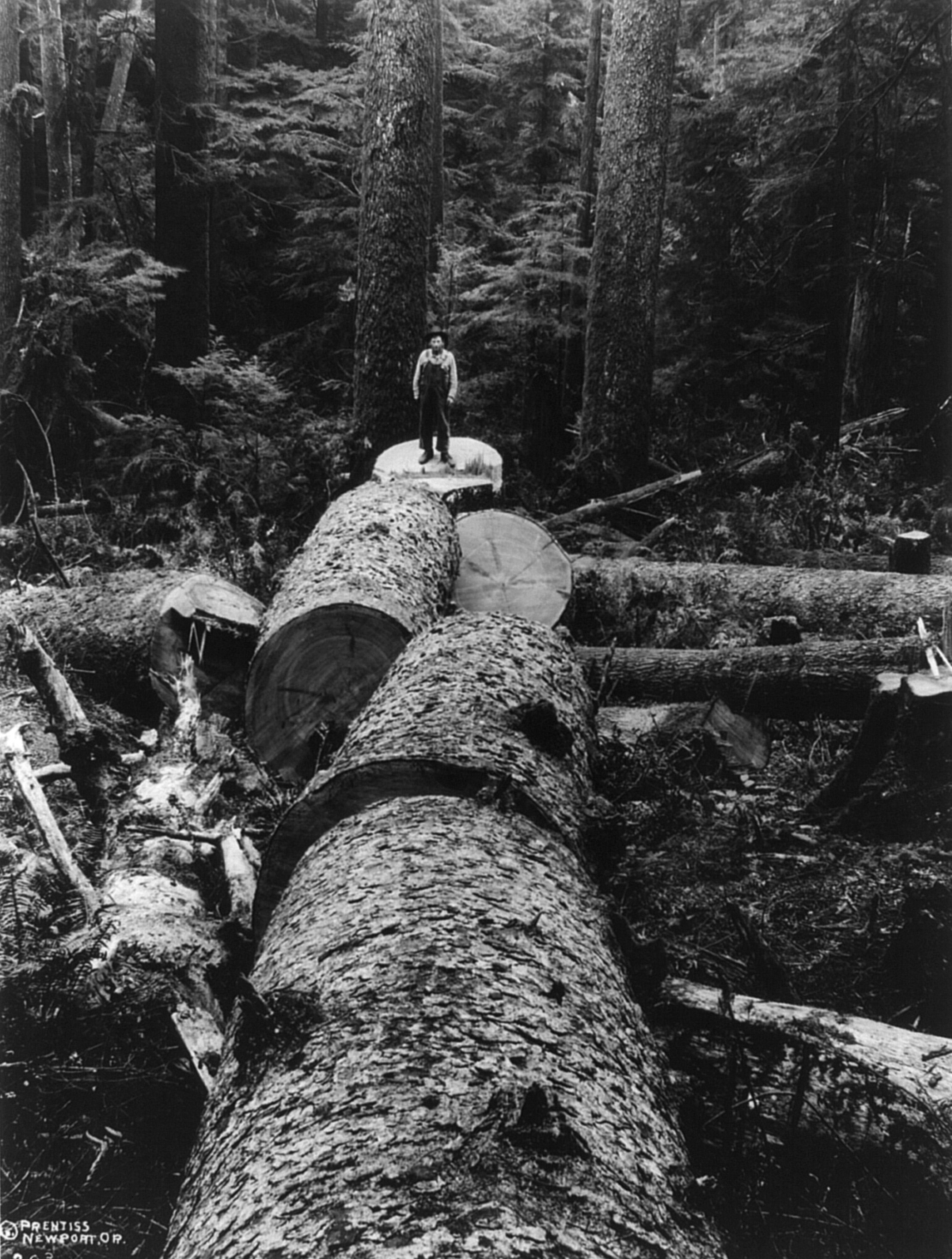
Sitka spruce logged in the Oregon Coast Range
-

Port Orford cedar, endemic to the Southern Oregon Coastal Mountains
-

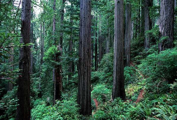
Coast redwood trees in Northern California
-

Vine maple
-

Grasses help stabilize the Oregon Dunes.
-

Salmonberry blossom
-

Salal flowers
Fauna
-

Douglas squirrel near the Oregon Coast
-

Snowy egret hunting fish
Landscapes
-

From Ecola State Park, a view of coastal uplands (foreground) and volcanic mountains (background)
-

Rock Creek Wilderness supports salmon, steelhead, and cutthroat trout.
-

Clearcutting in the Willapa Hills degrades stream quality.
-

Olympic rainforests have the highest living biomass density on earth.
-

The dynamic Lanphere Dunes in Humboldt County exemplify the coastal dune forest ecosystem.
See also
- Ecoregions defined by the EPA and the Commission for Environmental Cooperation:
- List of ecoregions in North America (CEC)
- List of ecoregions in the United States (EPA)
- List of ecoregions in Oregon
- List of ecoregions in Washington
- List of ecoregions in California
- The conservation group World Wildlife Fund maintains an alternate classification system:
References
- ^ a b c d e f g h i
 This article incorporates public domain material from the United States Geological Survey document "Ecoregions of Oregon" by Thorson, T.D., Bryce, S.A., Lammers, D.A., et al. (color poster with map, descriptive text, summary tables, and photographs; with a Reverse side).
 - ^ a b c d e f g h i j This article incorporates public domain material from the United States Geological Survey document "Ecoregions of Western Washington and Oregon" by Pater, D., Bryce, S.A., Kagan, J., et al. (color poster with map, descriptive text, summary tables, and photographs; with a Reverse side).
- ^ "Gymnosperm Database: Sequoia sempervirens". http://www.conifers.org/cu/se/index.htm. Retrieved 2008-05-01.
- ^ "Gymnosperm Database: Pseudotsuga menziesii". http://www.conifers.org/pi/ps/menziesii2.htm. Retrieved 2008-05-01.
- ^ "Gymnosperm Database: Picea sitchensis". http://www.conifers.org/pi/pic/sitchensis.htm. Retrieved 2008-05-01.
Level III Ecoregions in Oregon Marine West Coast Forest 1 Coast Range · 3 Willamette ValleyNorthwestern Forested Mountains North American Deserts as defined by the United States Environmental Protection Agency[1] Level III Ecoregions in the United States Marine West Coast Forest 1 Coast Range · 2 Puget Lowland · 3 Willamette Valley · 111 Ahklun and Kilbuck Mountains · 113 Alaska Peninsula Mountains · 115 Cook Inlet · 119 Pacific Coastal Mountains · 120 Coastal Western Hemlock-Sitka Spruce ForestsNorthwestern Forested Mountains 4 Cascades · 5 Sierra Nevada · 9 Eastern Cascades Slopes and Foothills · 11 Blue Mountains · 15 Northern Rockies · 16 Idaho Batholith · 17 Middle Rockies · 19 Wasatch and Uinta Mountains · 21 Southern Rockies · 41 Canadian Rockies · 77 North Cascades · 78 Klamath Mountains · 105 Interior Highlands · 116 Alaska Range · 117 Copper Plateau · 118 Wrangell MountainsMediterranean California 6 Southern and Central California Chaparral and Oak Woodlands · 7 Central California Valley · 8 Southern California MountainsNorth American Deserts 10 Columbia Plateau · 12 Snake River Plain · 13 Central Basin and Range · 14 Mojave Basin and Range · 18 Wyoming Basin · 20 Colorado Plateaus · 22 Arizona/New Mexico Plateau · 24 Chihuahuan Deserts · 80 Northern Basin and Range · 81 Sonoran Basin and RangeTemperate Sierras 23 Arizona/New Mexico MountainsGreat Plains 25 Western High Plains · 26 Southwestern Tablelands · 27 Central Great Plains · 28 Flint Hills · 29 Central Oklahoma/Texas Plains · 30 Edwards Plateau · 31 Southern Texas Plains · 34 Western Gulf Coastal Plain · 40 Central Irregular Plains · 42 Northwestern Glaciated Plains · 43 Northwestern Great Plains · 44 Nebraska Sand Hills · 45 Piedmont · 46 Northern Glaciated Plains · 47 Western Corn Belt Plains · 48 Lake Agassiz PlainEastern Temperate Forest 32 Texas Blackland Prairies · 33 East Central Texas Plains · 35 South Central Plains · 36 Ouachita Mountains · 37 Arkansas Valley · 38 Boston Mountains · 39 Ozark Highlands · 51 North Central Hardwood Forests · 52 Driftless Area · 53 Southeastern Wisconsin Till Plains · 54 Central Corn Belt Plains · 55 Eastern Corn Belt Plains · 56 Southern Michigan/Northern Indiana Drift Plains · 57 Huron/Erie Lake Plains · 59 Northeastern Coastal Zone · 60 Northern Appalachian Plateau and Uplands · 61 Erie Drift Plain · 63 Middle Atlantic Coastal Plain · 64 Northern Piedmont · 65 Southeastern Plains · 66 Blue Ridge · 67 Ridge and Valley · 68 Southwestern Appalachians · 69 Central Appalachians · 70 Western Allegheny Plateau · 71 Interior Plateau · 72 Interior River Valleys and Hills · 73 Mississippi Alluvial Plain · 74 Mississippi Valley Loess Plains · 75 Southern Coastal Plain · 82 Laurentian Plains and Hills · 83 Eastern Great Lakes and Hudson Lowlands · 84 Atlantic Coastal Pine BarrensNorthern Forests 49 Northern Minnesota Wetlands · 50 Northern Lakes and Forests · 58 Northeastern Highlands · 62 North Central AppalachiansTropical Wet Forests 76 Southern Florida Coastal PlainSouthern Semi-Arid Highlands 79 Madrean ArchipelagoTaiga 101 Arctic Coastal Plain · 102 Arctic Foothills · 103 Brooks Range · 104 Interior Forested Lowlands and Uplands · 106 Interior Bottomlands · 107 Yukon Flats · 108 Ogilvie MountainsTundra 109 Subarctic Coastal Plains · 110 Seward Peninsula · 112 Bristol Bay-Nushagak Lowlands · 114 Aleutian Islandsas defined by the United States Environmental Protection Agency[2] Categories:- Pacific Coast Ranges
- Ecoregions of the United States
- Regions of California
- Regions of Oregon
- Regions of Washington (state)
- Flora of Oregon
- Flora of Washington (state)
-


Wikimedia Foundation. 2010.