- Colliford Lake
-
Coordinates: 50°31′40″N 4°34′16″W / 50.52767°N 4.57100°W
 Colliford Lake
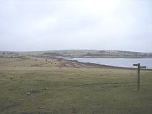 Northwest end of Colliford Lake
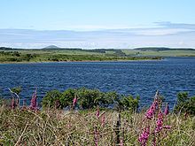
Colliford Lake is a reservoir on Bodmin Moor, Cornwall, United Kingdom. Covering more than 900 acres (3.6 km2),[1] it is the second largest lake in Cornwall, after The Loe. It is situated south of the A30 trunk road near the village of Bolventor, the approximate centre of the lake being at OS grid reference SX179730[2].
The northernmost point of the lake is approximately three-quarters of a mile (1 km) south of Bolventor at OS grid reference SX184756 and the headbank at the southermost point is approximately three miles (5 km) south of Bolventor at OS grid reference SX177709[3].
Leisure facilities on the site include angling and a 50-acre (200,000 m2) adventure and nature park, Colliford Lake Park,[4] which features trails and footpaths, play areas, wetlands, picnic areas and a cafe.[5]
Colliford Lake is managed by the South West Lakes Trust, an environmental and recreational charity which manages fifty inland water sites in Cornwall, Devon, and Somerset.[6]
References
- ^ Cornwall Calling website. Retrieved April 2010
- ^ Ordnance Survey: Landranger map sheet 201 Plymouth & Launceston ISBN 9780319231463
- ^ Ordnance Survey: Explorer map sheet 109 Bodmin Moor ISBN 9780319240472
- ^ Colliford Lake Park
- ^ Visit Britain website; Colliford Lake; retrieved April 2010
- ^ South West Lakes Trust website. Retrieved April 2010
Geography of Cornwall Unitary authorities Major settlements Bodmin • Bude • Callington • Camborne • Camelford • Falmouth • Fowey • Hayle • Helston • Launceston • Liskeard • Looe • Lostwithiel • Marazion • Newlyn • Newquay • Padstow • Par • Penryn • Penzance • Porthleven • Redruth • Saltash • St Austell • St Blazey • St Columb Major • St Ives • St Just-in-Penwith • St Mawes • Stratton • Torpoint • Truro • Wadebridge
See also: Civil parishes in CornwallRivers Topics History • Status debate • Flag • Culture • Places • People • The Duchy • Diocese • Politics • Hundreds/shires • Places of interest • full list...Categories:- Water supply stubs
- Cornwall geography stubs
- Bodmin Moor
- Drinking water reservoirs in England
- Geography of Cornwall


Wikimedia Foundation. 2010.