- Cowles Bog
-
Cowles Bog National Natural Landmark 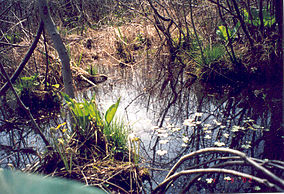
Cowles Bog in the spring with high water.Location Porter County, Indiana, USA Nearest city Michigan City, Indiana Coordinates 41°38′15″N 87°05′32″W / 41.6375°N 87.09222°WCoordinates: 41°38′15″N 87°05′32″W / 41.6375°N 87.09222°W Area Indiana Dunes National Lakeshore Established 1966 Governing body National Park Service Cowles Bog is named for Henry Chandler Cowles of the University of Chicago. Dr. Cowles is credited with the creation of the concept of Ecology. It was here at Cowles Bog that Dr. Cowles did his pioneering work. The bog is a National Natural Landmark.[1] Cowles Bog is more than 8,000 years old and is considered a fen, rather than a 'true' bog. Fens are more alkaline than a bog, which is acidic, like Pinhook Bog, also a part of the Indiana Dunes National Lakeshore.[2]
Contents
Location
The bog is located west of Mineral Springs Road. The general area is accessible by the Cowles Bog Trail of the Indiana Dunes National Lakeshore. Parking is available at the trailhead, just before the guardhouse to Dune Acres. The trail does not lead into the bog, which is nearly inaccessible due to the nature of the plant life surrounding it. See the description below. Dr. Cowles work included the bog, which is on the and of the marshlands to the south of the trail and the dune slopes to the north of the trail.[1]
Soils
The main body of the bog is composed of muck created from marsh plants and the woody plants that have encroached into the area. Surrounding the bog proper is an area covered with a thin layer of leaf litter over a thin layer of topsoil. The area is moderately acidic. Wet depressions exist which reveal a substratum of Maumee soils, a loamy fine sand. These loamy sands extend southward through the marsh area. To the north the dunes consist of Plainfield fine sand, which is heavily oxidized.[1]
Vegetation
The bog is a wetland woods. In the 1960s, there was still a noticeable open bog. This has effectively closed. The woods is dominated by Red maple and Yellow birch. There are tamarack, Paper birch, and White pine, which together only reach numbers equal to the Red maple and Yellow birch separately. Immature trees exist in all the lower layers of the woods with the Red maple and Yellow birch still dominating.[1]
The Shrub layer is along the bog’s edge and fills the center area of the bog. Dominant here are spicebush and poison sumac. The predominance of poison sumac makes access to the bog very difficult. Additionally, there are quantities of witch hazel, red osier, grape and blackberry.[1]
At ground level, the herb layer includes columbine, boneset, jewel weed, nettle, twinberry, May apple, hispid greenbrier, meadow rue, narrow-leaved cattail and grape.[1]
Orchids are becoming increasingly more common as restoration work has been going on putting orchids back in their natural habitat. Also Round-leaved sundew (Drosera rotundifolia) and Purple pitcher plant (Sarracenia purpurea) are increasingly more common.
Wildlife
The bog area primarily supports insect and bird life. Beavers have been known to inhabit the surrounding wetlands in 1988.[1]
Restoration
Since the early 1900s, when Dr. Cowles studied the 'bog', the land has been changing. The once diverse sedge meadow had been replaced by a monoculture of hybrid cattails. The National Park Service has identified that the changes which have caused this include: changes in seasonal water levels, water chemistry, changes in plant density, and changes in the soil and the seed banks. These changes have been the result of changes in the surrounding area, including the construction or roads and of drainage ditches. In 2009, the national lakeshore received a 3-year grant to begin the restoration of the bog.[2]
Cowles Bog Trail
The trail takes you along the northern edge of 'Cowles Bog'. The trail consist of three loops beginning at the Cowles Bog Trailhead parking area.[3] Lake Michigan can be reached on this trail in only 1.7 miles (2.7 km) by using the most direct route.
- The southern loop is 2.0 miles (3.2 km) long around the bog, with a return trip of about 0.8 miles (1.3 km) along Mineral Springs Road.
- The middle loop is 1.7 miles (2.7 km) and takes you into the dunes ridges and interdunal wetlands. It requires that you use the southern loop 0.8 miles (1.3 km) to get to and from it.
- The northern loop is connected to the middle loop and is 1.4 miles (2.3 km) long, crossing the foredunes and reaching Lake Michigan. This is the highest of the dunes and the steepest portion of the trail.

 Contours of the Cowles Bog Trail from the trailhead to Lake Michigan. Distances are in yards/meters. Vertical height exaggerated three times horizontal.
Cowles Research
- Cowles, H.C. 1899. Ecological relation of the vegetation on sand dunes of Lake Michigan. Bot. Gaz 27: 95-117; 167-202; 281-308; 361-388[1]
- ----------------. 1901. The physiographic ecology of Chicago and vicinity. Bot. Gaz. 31: 73-108; 145-182[1]
- ----------------. 1901. The plant societies of Chicago and vicinity. Bull. Geog. Soc. Of Chicago, No 2: 1-76[1]
See also
Sources
- Bennett, L.F. 1917. The sand dune region as a national park. Proc. Indiana Acad. Sci. 26: 261-263
- Buhl, C. A. 1935. Notes on the flora of the Indiana Dunes. Am Midland Nat. 16: 248-253[1]
- Cressey, G.R. 1928. The Indiana sand dunes and shore lines of the Lake Michigan basin. Univ. Chicago Press. Geog. Soc. Of Chicago, Bull. 8
- Eifrig, C.W. 1919. The birds of the sand dunes of northwestern Indiana. Proc Indiana Acad. Sci. 28: 280-303
- Lyon, M.W. Jr, 1923. Notes on the mammals of the dune region of Porter County, Indiana. Proc. Indiana Acad. Sci. 32: 209-221
- -------------------- 1924. Some soil and water reactions in the dunes region of Porter County. Proc Indiana Acad. Sci. 33: 281-284
- Olson, J.S. 1951. Vegetation –substrate relations in the Lake Michigan sand dunes. Ph.D. Dissertation, Univ. Chicago.
- ------------. 1958. Rates of succession and soil changes on southern Lake Michigan sand dunes. Bot. Gaz. 119: 125-170
- Peattie, D.C. 1930. Flora of the Indiana Dunes. Field Museum of Nat. History Chicago, 432p.
- Potzger, J.E. 1938. Some acidity studies in dunes and bogs. Proc. Indiana Acad. Sci 47: 100-105
- Rand, A. L. and A.S. Rand. 1946. Mammal bones from dunes south of Lake Michigan. Am. Midland Nat. 46: 649-659.
- Tryon, R.M. Jr. 1936. Ferns of the dune region of Indiana. Amer. Midland Nat. 17: 425-249.
References
- ^ a b c d e f g h i j k Natural Areas in Indiana and Their Preservation; Lindsey, Alton A., Damian V. Schmelz, Stanley A. Nichols; American Midland Naturalist, Dept of Biology, University of Notre Dame, Notre Dame, Indiana, 1969; pg 523-530
- ^ a b The Singing Sands; Vol. 30, NO. 2, Fall 2009; National Park Service, Indiana Dunes National Lakeshore; Porter, Indiana
- ^ Indiana Dunes National Lakeshore; Cowles Bog Trail, National Park Service
National Natural Landmarks in Indiana Big Walnut Creek • Cabin Creek Bog • Calvert and Porter Woods • Cowles Bog • Davis-Purdue Agriculture Center Forest • Donaldson Cave System and Woods • Dunes Nature Preserve • Fern Cliff • Hanging Rock and Wabash Reef • Harrison Spring • Hammer Woods • Hoosier Prairie • Hoot Woods • Kramer Woods • Marengo Cave • Meltzer Woods • Officer's Woods • Ohio Coral Reef • Pine Hills Natural Area • Pinhook Bog • Pioneer Mother's Memorial Forest • Portland Arch Nature Preserve • Rise at Orangeville • Rocky Hollow Falls Canyon Nature Preserve • Shrader-Weaver Woods • Tamarack Bog • Thornhill Nature Preserve • Tolliver Shallowhole • Wesley Chapel Gulf • Wesselman Woods Nature Preserve • Wyandotte CavesList including county and description Categories:- Bogs of Indiana
- Indiana Dunes National Lakeshore
- National Natural Landmarks in Indiana
- Protected areas of Porter County, Indiana
- Protected areas of Indiana
- Protected areas established in 1966


Wikimedia Foundation. 2010.