- Crum Road Bridge
-
Crum Road Bridge
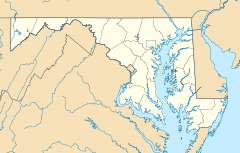

Nearest city: Walkersville, Maryland Coordinates: 39°28′47″N 77°19′39″W / 39.47972°N 77.3275°WCoordinates: 39°28′47″N 77°19′39″W / 39.47972°N 77.3275°W Built: 1875 Architect: King Iron Bridge Co. Architectural style: Other Governing body: Local NRHP Reference#: 78001463
[1]Added to NRHP: December 28, 1978 The Crum Road Bridge is a historic bridge near Walkersville, Frederick County, Maryland, United States. It spans Israel Creek southeast of Walkersville. The bridge is an iron bowstring pony truss bridge that is 62 feet in length and 15.8 feet in width. It was built about 1875, probably by the King Iron Bridge Company of Cleveland, Ohio.[2]
The Crum Road Bridge was listed on the National Register of Historic Places in 1978.[1]
References
- ^ a b "National Register Information System". National Register of Historic Places. National Park Service. 2008-04-15. http://nrhp.focus.nps.gov/natreg/docs/All_Data.html.
- ^ "Maryland Historical Trust". Crum Road Bridge. Maryland Historical Trust. 2008-11-21. http://www.mht.maryland.gov/nr/NRDetail.aspx?HDID=509&COUNTY=Frederick&FROM=NRCountyList.aspx?COUNTY=Frederick.
External links
- Crum Road Bridge, Frederick County, including photo in 1977, at Maryland Historical Trust
U.S. National Register of Historic Places in Maryland Lists by county Allegany • Anne Arundel • Baltimore County • Calvert • Caroline • Carroll • Cecil • Charles • Dorchester • Frederick • Garrett • Harford • Howard • Kent • Montgomery • Prince George's • Queen Anne's • Somerset • St. Mary's • Talbot • Washington • Wicomico • Worcester
Lists by city Other lists Keeper of the Register • History of the National Register of Historic Places • Property types • Historic district • Contributing property Bridges and tunnels on the National Register of Historic Places Alabama · Alaska · Arizona · Arkansas · California · Colorado · Connecticut · Delaware · Florida · Georgia · Guam · Hawaii · Idaho · Illinois · Indiana · Iowa · Kansas · Kentucky · Louisiana · Maine · Maryland · Massachusetts · Michigan · Minnesota · Mississippi · Missouri · Montana · Nebraska · Nevada · New Hampshire · New Jersey · New Mexico · New York · North Carolina · North Dakota · Ohio · Oklahoma · Oregon · Pennsylvania (covered) · Puerto Rico · Rhode Island · South Carolina · South Dakota · Tennessee · Texas · Utah · Vermont · Virginia · Washington · Washington, D.C. · West Virginia · Wisconsin · Wyoming
Categories:- Bridges on the National Register of Historic Places in Maryland
- Bridges in Frederick County, Maryland
- King Bridge Company
- Road bridges in Maryland
- Frederick County, Maryland Registered Historic Place stubs


Wikimedia Foundation. 2010.