- Davidka Square
-
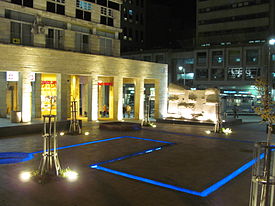 Davidka Square at night, looking toward the back of the Davidka memorial and Jaffa Road.
Davidka Square (Hebrew: כיכר הדוידקה, Kikar HaDavidka) is a public square at the intersection of Jaffa Road, Street of the Prophets, and Kiach Road in Jerusalem, Israel. Its official name is Kikar Haherut (Hebrew: כיכר החירות, Freedom Square).[1][2] It features a small memorial to the Davidka, a homemade Israeli mortar used in the defense of Jerusalem and other cities during the 1948 War of Independence.
Contents
Background
Main article: DavidkaIn the early stages of the War of Independence, the Israeli army had no artillery other than a primitive, homemade mortar that was not accurate but that made a thunderous explosion.[3][4][2] The noise from this weapon – called the Davidka ("Little David") after its inventor, engineer David Leibovitch – often sent the enemy fleeing in panic.[2][5][6] Mistaking the Davidka's explosion for an atomic bomb, the Arabs abandoned the northern town of Safed.[7] The mortar was also used by the Harel Brigade in its defense of Jerusalem.[4] The Israeli army used the Davidka exclusively until July 1948, when it was able to acquire conventional artillery such as mountain howitzers, cannons and field guns.[8]
Memorial
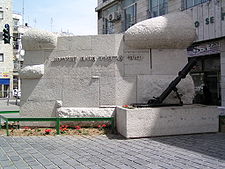 The memorial in 2006.
In 1956 the Jerusalem municipality commissioned a memorial to the Davidka designed by architect Asher Hiram.[1] A Davidka used by the Harel Brigade was mounted on a stone platform engraved with part of the verse from the Book of Kings: "I will defend this city, to save it" (2 Kings 19:34).[2][5] Two small, rounded projections on one side of the memorial and one larger protection on the other evoke the shape of the cap worn by Palmach soldiers.[5] On Israeli Fallen Soldiers and Victims of Terrorism Remembrance Day, people leave flowers and wreaths on the Davidka in memory of the soldiers who died in defense of the city.
Renovation
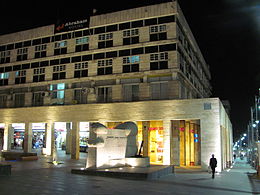 Partial view of Davidka Square at night, with the Davidka memorial at center and vertically-lit stone columns fronting the shopping arcade.
Davidka Square is one of the few commercial squares in the city.[1] It is surrounded on three sides by shops, and opens on to Jaffa Road, a major commercial artery. For decades it stood as a dreary, gray corner.[9] In 2009,[1] when work on the Jerusalem Light Rail project necessitated extensive infrastructure and redesign work on all three squares on Jaffa Road – the others being Tzahal Square near the Old City walls and Zion Square[10] – the Jerusalem municipality hired Mexican architect Ricardo Legorreta to renovate Davidka Square.[1]
Legorreta's plan enlarged the area designated for pedestrians and greenery to 99.486 square feet (9.2426 m2). He paved the square with reddish stones and added a blue trench as a "water element". To emphasize the historical importance of the site, Legorretta also designed elements on a double scale. These include a wall measuring 18 metres (59 ft) high and 9 metres (30 ft) wide, covered by red ceramic plaques, allowing the square "to be identified from far away" and stone columns 4.5 metres (15 ft) in height that function as "vertical lamps" during the night.[11] The standout design elements generated controversy among Jerusalem residents when they were first proposed.[1] Public opposition to the red wall nixed that design element.
Other Davidka memorials
Another Davidka memorial stands a few meters south of Safed's Town Hall, opposite the old British police station.[12][13] The memorial, established on 29 April 1956 and renovated in the 2000s, includes an engraved stone marker and an audio information post relating information about the liberation of Safed in both Hebrew and English, along with seating for tour groups. Every year on Israel's Remembrance Day, the city conducts a wreath-laying ceremony here.[14]
A Davidka also stands on display at the Beit Hativat Givati Museum in Metzudat Yoav.[15]
References
- ^ a b c d e f Zandberg, Esther (6 January 2009). "The Mexican's Magic Hat". Haaretz. http://www.haaretz.com/print-edition/news/the-mexican-s-magic-hat-1.267504. Retrieved 30 March 2011.
- ^ a b c d Eisenberg, Ronald (30 September 2006). The Streets of Jerusalem: Who, What, Why. Devora Publishing. pp. 145–146. ISBN 9781932687545. http://books.google.com/books?id=yqXXD_74yAEC&pg=PA145&dq=davidka+square&hl=en&ei=gkuSTbH-Bo3d4gaV8_WiAg&sa=X&oi=book_result&ct=result&resnum=5&ved=0CD0Q6AEwBA#v=onepage&q=davidka%20square&f=false.
- ^ Brecker, S. Michael. "Extracts from my Memoirs as a Volunteer in Israel’s War of Independence, 1948 – 1949". World Machal. http://www.machal.org.il/index.php?option=com_content&view=article&id=233&Itemid=321&lang=en. Retrieved 30 March 2011.
- ^ a b "Congratulations Caroline Glick Defender of Jerusalem". One Jerusalem. 6 March 2009. http://www.onejerusalem.org/2009/06/congratulations-caroline-glick.php. Retrieved 30 March 2011.
- ^ a b c Bar-Am, Aviva (25 January 2010). "Rehov Hanevi'im – Around the houses". The Jerusalem Post. http://www.jpost.com/LandedPages/PrintArticle.aspx?id=166738. Retrieved 30 March 2011.
- ^ Milstein, Uri; Sacks, Alan (1998). History of the War of Independence: The first invasion. University Press of America. p. 148. ISBN 0761807691. http://books.google.com/books?ei=lEqTTdH1F-SJ4gao45muAg&ct=result&id=3cxtAAAAMAAJ&dq=davidka+harel+siege+jerusalem&q=davidka. "The Jews have an atom bomb, word raced through the Arab settlements. An Arab information agency reported the use of 'artillery and other secret weapons in the Jewish attack on Abu-Kabir.'"
- ^ Joseph, Bernard (1960). The Faithful City: The siege of Jerusalem, 1948. Simon and Schuster. p. 73. http://books.google.com/books?id=xkcxAAAAIAAJ&pg=PA73&sig=ACfU3U2-7hNZHk4i46wWZper1xBzW_rhSg&q=atomic. "Its effect on the Arabs was sometimes considerable, notably at Safad, where they mistook it for an atomic weapon when they abandoned the city."
- ^ The American Zionist, Volumes 55-57, Zionist Organization of America, 1965, pp. 24–25, http://books.google.com/books?ei=UlSSTbTnGYvo4ga94Y2VAg&ct=result&id=KnfxAAAAMAAJ&dq=davidka+square&q=fond+weapons
- ^ Zohar, Gil (31 December 2010). "Kikar Davidka's Vibrant Revival". The Jerusalem Post. http://www.highbeam.com/doc/1P1-188515058.html. Retrieved 30 March 2011.
- ^ Lichtman, Gail (29 December 2006). "Central Jerusalem Gets Facelift". Jewish Independent. http://www.jewishindependent.ca/archives/Dec06/archives06Dec29-08.html. Retrieved 30 March 2011.
- ^ "Master Plan: Davidka Square". Legorretta + Legorretta. http://www.legorretalegorreta.com/lego_new/english/proyectos_detalle.php?id=96. Retrieved 30 March 2011.
- ^ Jacobs, Daniel (September 1998). Israel and the Palestinian Territories: The rough guide. Rough Guides, Ltd.. p. 242. ISBN 1858282489. http://books.google.com/books?id=TRc9ea_CKOUC&pg=RA1-PA242&dq=davidka+safed&hl=en&ei=3mGSTf79HsrA4gaZj_m3Ag&sa=X&oi=book_result&ct=result&resnum=8&ved=0CEsQ6AEwBw#v=onepage&q=davidka%20safed&f=false.
- ^ Kohn; Assaf, Roxane; Rafael, Miriam; Thomas, Amelia (1 March 2007). Israel & the Palestinian Territories. Lonely Planet. p. 277. ISBN 9781864502770. http://books.google.com/books?id=K_vDAu6UoSwC&pg=PA277&dq=davidka+safed&hl=en&ei=amWSTeDjNJHx4QbJwqi9Ag&sa=X&oi=book_result&ct=result&resnum=4&ved=0CDgQ6AEwAzgK#v=onepage&q=davidka%20safed&f=false.
- ^ "The Davidka Monument". safed.co.il. 2009. http://www.safed.co.il/davidka-monument.html. Retrieved 30 March 2011.
- ^ "Davidka Mortar". David Pride. 2011. http://www.davidpride.com/Israel/Givati_07.htm. Retrieved 30 March 2011.
External links
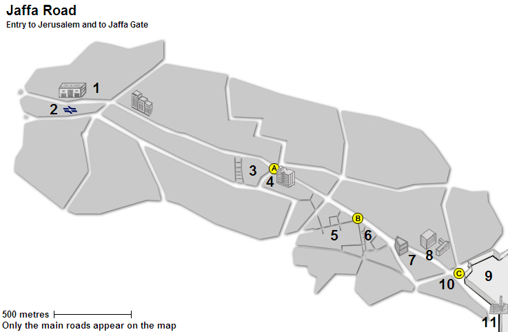
Jaffa Road 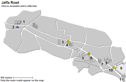
Places 1. Central Bus Station · 2. Railway station (planned) · 3. Mahane Yehuda Market · 4. Klal Center
5. Ben Yehuda Street · 6. Nahalat Shiva · 7. Generali Building · 8. Safra Square / City Hall · 9. Old City
10. Mamilla · 11. Jaffa Gate / Tower of DavidSquares A. Davidka Square · B. Zion Square · C. Tzahal Square · D. Safra Square Categories:- Squares in Jerusalem
- Monuments and memorials in Israel


Wikimedia Foundation. 2010.