- Derby Road railway station
-
Derby Road 
Location Place Ipswich Local authority Ipswich Operations Station code DBR Managed by National Express East Anglia Number of platforms 2 Live arrivals/departures and station information
from National Rail EnquiriesAnnual rail passenger usage 2004/05 * 30,872 2005/06 *  32,525
2006/07 * 35,9372007/08 * 39,3192008/09 *  38,920
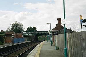
2009/10 * 35,868National Rail - UK railway stations A B C D E F G H I J K L M N O P Q R S T U V W X Y Z * Annual passenger usage based on sales of tickets in stated financial year(s) which end or originate at Derby Road from Office of Rail Regulation statistics. Please note: methodology may vary year on year. Derby Road is a railway station serving the Rose Hill area of Ipswich in Suffolk. The station is situated on the Ipswich-Felixstowe line. In the eighties there were rail served coal and scrapyards here, but these have now closed. There were also rail served factories to the south-east serving Crane's and Ransome Simms & Jefferies, also now removed.
The station is served by National Express East Anglia.
Contents
History
Derby Road station was opened in 1877 when the line from Westerfield Junction to Felixstowe opened. It attracted much local criticism in Ipswich as, at the time, it was inconveniently placed for the rest of the town. Prior to opening day when the line was being inspected the mayor made representations for a new station some half mile to the north between Spring Road and Woodbridge Road.[1]
Trams from Ipswich Cornhill used to arrive at the back of the station (in fact there was a horse tram shed at the side of the still existing Railway Hotel). Services ran to Felixstowe either from Ipswich or from Derby Road at busy times from a platform now covered by fencing belonging to the car sales company. Also a siding used to run behind the up platform and rolling stock was still stored there until the 1970s. The gent's toilet on the up platform was closed in the early 1980s. The signal box was removed in the late 1990s and the original up platform shelter was demolished in 2005 following years of vandalism. Part of the goods yard is now the garden/playground of Rose Hill School. Two Victorian Coal Merchants offices were removed in the early 1990s. The bridge under Derby Road was rebuilt in 2003 to take the higher containers from Felixstowe Docks. The temporary footbridge erected at this time is still extant although disused.
In the summer of 2011, a planning application was made which will see the demolition of the station buildings, removal of the car park and cycle racks. In its place, an old people's home will be built.[2]
Train Services
The following services currently call at Derby Road:
Operator Route Material Frequency NXEA Ipswich - Westerfield - Derby Road - Trimley - Felixstowe Class 153 1x per hour Preceding station  National Rail
Following station National Express East Anglia Historical railways Line and station openGreat Eastern Railway Line open, station closedFormer Service
When the line opened on May 1st 1877 Derby Road was served by 4 trains between Westerfield Junction and Felixstowe Pier. There were also two trains from Felixstowe that terminated at Derby Road and one that originated. By 1879 the service between Westerfield and Derby Road had increased to 6 trains per day and when the Great Eastern Railway took over the working of the line in September 1879 through working to Ipswich was begun. The 1939 timetable had 20 up (towards London) and 21 down services as well as three up and 4 down services that ran through to Liverpool Street. In 1951 the service had 19 workings in each direction (with 16 down and 15 up on a Sunday). By 1973 the service was operating 13 trains each way between Ipswich and Felixstowe Town station.
Orwell Halt
Between 'Derby Road' and 'Trimley' there was a station called 'Orwell'. Although situated in the middle of woods it was built to serve Colonel Tomline's House at Orwell Park. The station was the only original loop on the single track branch and according to the 1926 plan had a small goods yard. The station closed in 1955 although the station house is occupied and can be glimpsed through the trees especially after dark when it can look quite eerie. The Orwell Goods yard is also fairly obvious as a large clearing in the forest just south of the old station.
Bibliography
Alderson and Kenworthy Branch Lines to Felixstowe and Aldeburgh (Middleton Press 2003) ISBN 1-904474-20-9 H I Quayle and G T Bradbury, The Felixstowe Railway (The Oakwood Press 1978)
References
External links
- Train times and station information for Derby Road railway station from National Rail
Categories:- Railway stations in Suffolk
- Former Great Eastern Railway stations
- Railway stations served by National Express East Anglia
- DfT Category F2 stations

Wikimedia Foundation. 2010.