- Mahukona, Hawaii
-
Māhukona light 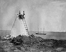
Original Māhukona light, 1904 Coordinates 20°10′49″N 155°54′5″W / 20.18028°N 155.90139°W Year first lit 1889 Deactivated 1915 Māhukona is a former settlement on the island of Hawaiʻi. The extinct submerged volcano Māhukona, off shore and to the south, is named for this area. It was once the terminus of the Hawaiian Railroad.
History
Māhukona was a traditional land division (ahupuaʻa) that extended from a bay to the slopes of Kohala mountain. Much was owned by Princess Ruth Keʻelikōlani at one time. The name means "false harbor" in the Hawaiian language.[1] Lapakahi State Historical Park is just to the south.[2] The harbor is located at 20°11′1″N 155°54′2″W / 20.18361°N 155.90056°WCoordinates: 20°11′1″N 155°54′2″W / 20.18361°N 155.90056°W just off of Akoni Pule Highway, Hawaii Route 270.[3]
While Samuel Garner Wilder was minister of the interior, he secured a charter for a railroad company in 1880. The first sugar plantation in the Kohala district was started by Elias Bond in 1863, but transportation proved difficult. Wilder's idea was to transport sugarcane from sugar plantations on the wet windward side of Kohala to Māhukona where ships could land. Wilder already ran a steamship company, so built a pier at the Māhukona harbor. Samuel Parker planned a railroad from the east coast to the port of Hilo, but was unable to fund the project.[4] Work was begun in 1881, the first track opened in 1882, and by 1883 had reached about 20 miles (32 km) to the plantation at Niuliʻi, 20°13′23″N 155°44′48″W / 20.22306°N 155.74667°W.[5] There it met the barrier of Pololu Valley.
 Hawaiian Railroad near Māhukona in newly built in 1882
Wilder named the first locomotive Kinau, after his wife.[6] He had plans to extend his railroad to Hilo, but that would not happen until after his death, by the Hawaii Consolidated Railway. The two would never be connected as dreamed by Wilder. In 1897 the railroad reincorporated as the Hawaii Railway Company, Ltd., and was bought out by the sugar companies in 1899.[4]
A sugar mill was built on the north side of the bay, and its remains still stand. A larger wharf was built in 1911 by the Territory of Hawaii that was immediately destroyed by a storm, and rebuilt again. In 1913 it was the fourth busiest port in the islands, but only had 13 vessels enter.[7] The first lighthouse was built in 1889 just to the south of the bay. In 1915 it was replaced by a concrete pyramid 22 feet (6.7 m) tall.[8] By 1937, the Kohala Sugar Company had considated all the business into the mill at Māhukona, and became Mahukona Terminals Ltd. In 1941 the port was forced to close for World War II. On October 29, 1945 the railroad shut down.[4]
The town which once consisted of about 40 families, was abandoned in the 1950s.[9] In 1956 the harbor was closed. The bay is now the site of a park of Hawaii County. Although called Māhukona Beach Park, the shoreline is rocky and there is no sandy beach. Fishing, picnic areas, and camping are available.[10]
In the 1990s a developer obtained permits to build a golf course and resort in the area.[11] The land-holding company was renamed the Kohala Preserve Conservation Trust, LLC, but encountered opposition from residents in the area.[12] A historic song about Māhukona, translated as "sugar boiler"[13] was recently recorded.[14]
References
- ^ Lloyd J. Soehren (2004). "lookup of Mahukona". on Hawaiian place names. Ulukau, the Hawaiian Electronic Library. http://ulukau.org/cgi-bin/hpn?e=p&a=q&l=en&q=Mahukona&d=HASH01662761228aad4197441eb1. Retrieved July 27, 2010.
- ^ Lapakahi State Historical Park entry on Hawaiʻi State Park web site
- ^ U.S. Geological Survey Geographic Names Information System: Māhukona
- ^ a b c Veronica S. Schweitzer (January 1998). "Sugar and Steam in Kohala". Coffee Times. http://www.coffeetimes.com/jan98.htm. Retrieved July 27, 2010.
- ^ Anne M. Prescott (1899). Makapala-by-the-sea: Hawaii. Hawaiian Gazette Company. p. 19. http://books.google.com/books?id=VvcqmqEc6ZwC&pg=PA19.
- ^ J. C. Condé (1971). Narrow gauge in a kingdom: the Hawaiian Railroad Company, 1878-1897. Glenwood Publishers. http://books.google.com/books?id=btFdAAAAIAAJ.
- ^ Chamber of Commerce of Honolulu (1914). Annual report. pp. 30, 48. http://books.google.com/books?id=GAUXAQAAIAAJ&pg=PA48.
- ^ United States Deptartment of Commerce (1918). Report of the Secretary of Commerce and reports of bureaus. Government Printing Office. pp. 595, 598. http://books.google.com/books?id=Wi7VAAAAMAAJ&pg=PA598.
- ^ "A grand Mahalo to our Māhukona ‘Ohana". Kohala Preserve Conservation Trust web site. October 27, 2009. http://www.kohalapreserve.com/news/46/a-grand-mahalo-to-our-mahukona-ohana. Retrieved July 27, 2010.
- ^ "North Kohala map". Shoreline access. on official Hawaiʻi County web site. http://www.co.hawaii.hi.us/planning/spa/north_kohala/map3.html. Retrieved July 27, 2010.
- ^ "Surety Holdings Corp—10SB12G". US Securities and Exchange Commission. February 9, 2001. http://www.secinfo.com/dsvr4.41Z7.htm. Retrieved July 27, 2010.
- ^ David Kimo Frankel (July 2009). "Māhukona development challenged". Ka Wai Ola Loa 2 (7). http://www.oha.org/kwo/loa/2009/07/story14.php. Retrieved July 27, 2010.
- ^ Kīhei de Silva (1997). "Māhukona". He Aloha Moku o Keawe: A Collection of Songs for Hawai‘i. Kamehameha Schools. http://apps.ksbe.edu/kaiwakiloumoku/kaleinamanu/he-aloha-moku-o-keawe/mahukona. Retrieved July 27, 2010. credited to book by Edward Kamakau Likalani (1852–1917).
- ^ "Hoʻokena 5". album listing on Hoʻokena web site. 1999. http://www.hookena.com/album-pages/hookena-5/hookena-5.html. Retrieved July 27, 2010. includes audio clip of song, track 14
External links
- Thomas A. Edison, Inc. (1906). "S.S. Kinau landing passengers, Mahukona, Hawaii". US Library of Congress. http://lccn.loc.gov/88706685. Retrieved July 26, 2010.
- "Minor light of Hawai'i - Mahukona, HI". Lighthouse friends web site. http://www.lighthousefriends.com/light.asp?ID=902. Retrieved July 26, 2010.
Railroads of Hawaii Tourist HARX • Heritage railways in Kauai • KPRY • LKP
Former See also: List of United States railroads by political divisionCategories:- Ghost towns in Hawaii
- Hawaii County, Hawaii
- Bays of Hawaii
- Landforms of Hawaii (island)


Wikimedia Foundation. 2010.