- Máramaros County
-
Máramaros County
Комітат Марамарош
Comitatul Maramureş
Comitatus Maramarosiensis
Máramaros vármegye
Komitat MaramureschCounty of the Kingdom of Hungary 1876–1920 
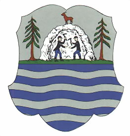
Coat of arms

Capital Máramarossziget History - Established 1876 - Treaty of Trianon June 4 1920 Area - 1910 9,716 km2 (3,751 sq mi) Population - 1910 357,700 Density 36.8 /km2 (95.4 /sq mi) Today part of Ukraine, Romania Sighetu Marmaţiei is the current name of the capital. Máramaros (Romanian: Maramureș; Rusyn: Мараморош / Maramorosh, Мараморыш / Maramorŷsh; Ukrainian: Мармарощина / Marmaroshchyna, Мараморщина / Maramorshchyna; Latin: Marmatia) is the name of a historic administrative county (comitatus) of the Kingdom of Hungary. Its territory is presently in north-western Romania and western Ukraine. The capital of the county was Máramarossziget (-Hungarian, at present Sighetu Marmaţiei in Romania).
Contents
Geography
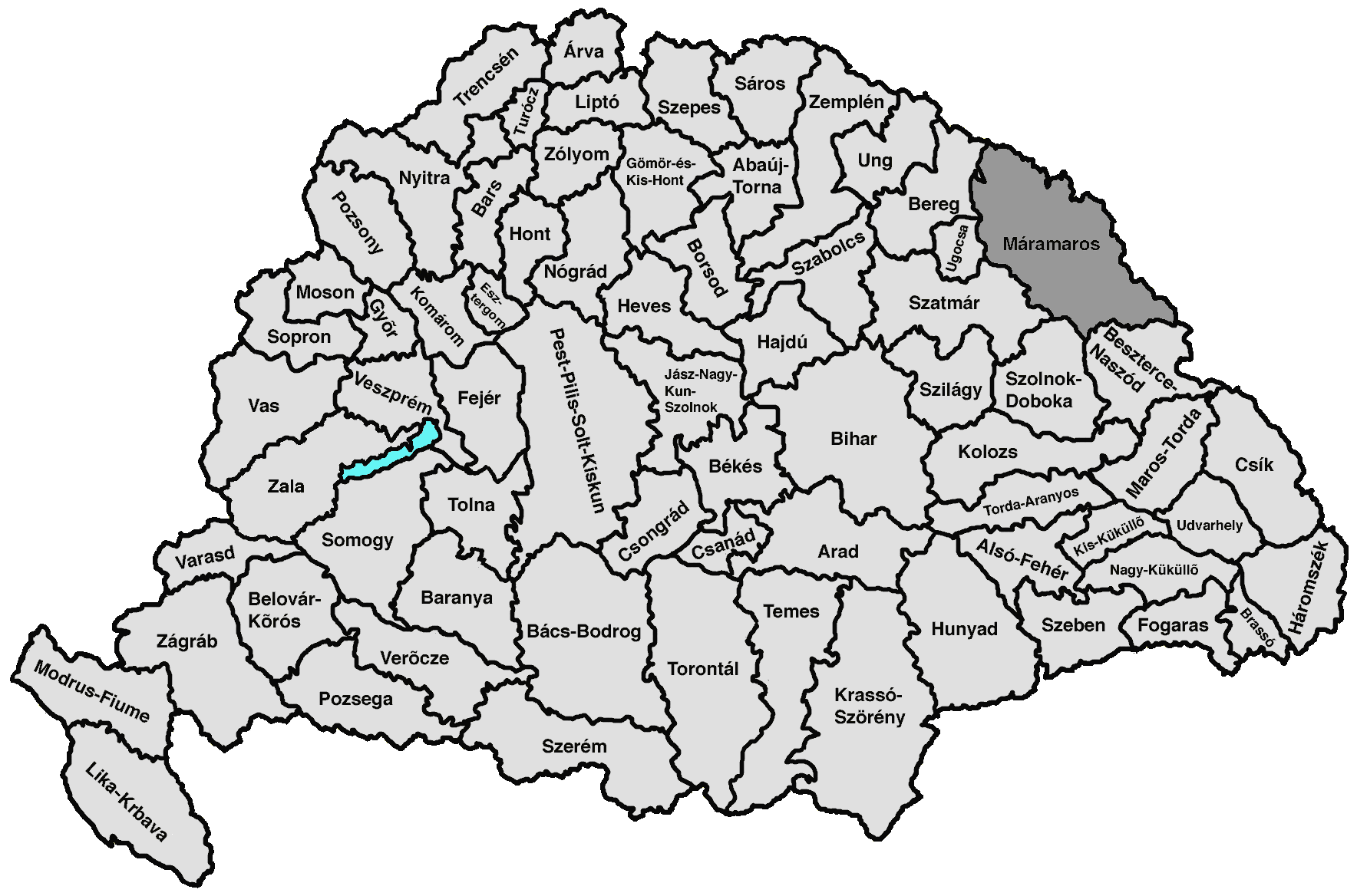
Máramaros county shared borders with the Austrian crownlands Galicia (currently in Poland and Ukraine) and Bukovina (currently in Romania and Ukraine) and the Hungarian counties Bereg, Ugocsa, Szatmár, Szolnok-Doboka and Beszterce-Naszód. It was situated on both sides of the river Tisza, and in the Carpathian mountains. Its area was 9720 km² around 1910.
History
In 1920 after the Treaty of Trianon, the northern part of the county became part of newly formed Czechoslovakia. The southern part (including Sighetu Marmației) became part of Romania.
During World War II, the Czechoslovak part was occupied by Hungary under the First Vienna Award. The county Máramaros was recreated, with Khust/Huszt as capital. The Romanian part was from 1940 to 1944 a part of Hungary. After World War II, the formerly Czechoslovak part of Máramaros county became part of the Soviet Union, Ukrainian SSR, Zakarpattia Oblast. Since 1991, when the Soviet Union split up, the Zakarpattya region is part of Ukraine.
The southern part of the county is now part of the Romanian county Maramureș.
Demographics
Population by language (1910 census):
- Ruthenian = 159,489 (44.59%)
- Romanian = 84,510 (23.63%)
- German = 59,552 (16.65%)
- Hungarian = 52,964 (14.81%)
Religion (1910 census):
- Greek Catholic 71.1%
- Jewish 18.4%
- Roman Catholic 7.3%
- Calvinist 2.7%
- Greek Orthodox 0.4%
- Lutheran 0.1%
Subdivisions
In the early 20th century, the subdivisions of Máramaros county were:
Districts (járás) District Capital Dolha Dolha, UA Dovhe Huszt Huszt, UA Khust Izavölgy Dragomérfalva, RO Dragomireşti Ökörmező Ökörmező, UA Mizhhir'ya Sugatag Aknasugatag, RO Ocna Şugatag Sziget Máramarossziget, RO Sighetu Marmaţiei Taracviz Taracköz, UA Teresva Técső Técső, UA Tiachiv Tiszavölgy Rahó, UA Rakhiv Visó Felsővisó, RO Vişeu de Sus Urban districts (rendezett tanácsú város) Máramarossziget, RO Sighetu Marmaţiei Rakhiv, Teresva, Tiachiv, Khust, Dovhe and Mizhhir'ya are presently in Ukraine; Sighetu Marmaţiei, Ocna Şugatag, Dragomireşti and Vişeu de Sus are presently in Romania.
Counties of the Kingdom of Hungary (1886) Abaúj-Torna · Alsó-Fehér · Arad · Árva · Bács-Bodrog · Baranya · Bars · Békés · Bereg · Beszterce-Naszód · Bihar · Borsod · Brassó · Csanád · Csík · Csongrád · Esztergom · Fejér · Fogaras · Gömör-Kishont · Győr · Hajdú · Háromszék · Heves · Hont · Hunyad · Jász-Nagykun-Szolnok · Kis-Küküllő · Kolozs · Komárom · Krassó-Szörény · Liptó · Máramaros · Maros-Torda · Moson · Nagy-Küküllő · Nógrád · Nyitra · Pest-Pilis-Solt-Kiskun · Pozsony · Sáros · Somogy · Sopron · Szabolcs · Szatmár · Szeben · Szepes · Szilágy · Szolnok-Doboka · Temes · Tolna · Torda-Aranyos · Torontál · Trencsén · Turóc · Udvarhely · Ugocsa · Ung · Vas · Veszprém · Zala · Zemplén · Zólyom
Corpus separatum: Fiume
Autonomous Kingdom of Croatia-Slavonia: Bjelovar-Križevci · Lika-Krbava · Modruš-Rijeka · Požega · Srijem · Varaždin · Virovitica · Zagreb
 Categories:
- States and territories established in 1876
- States and territories disestablished in 1920
- Counties in the Kingdom of Hungary
- Kingdom of Hungary counties in Transylvania
- Maramureş

Wikimedia Foundation. 2010.