- Marlborough Fault System
-
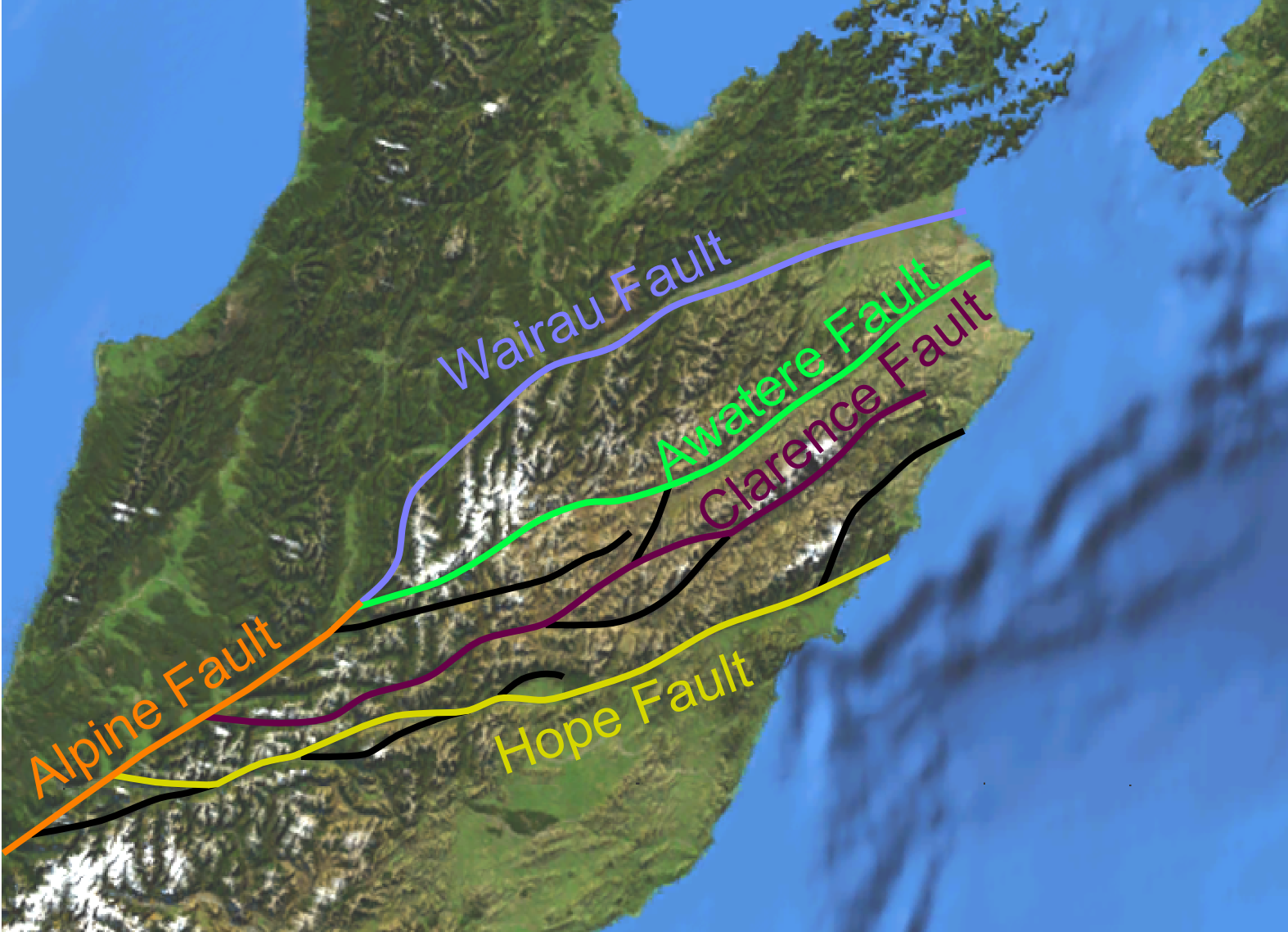
 Map of the Marlborough Fault System
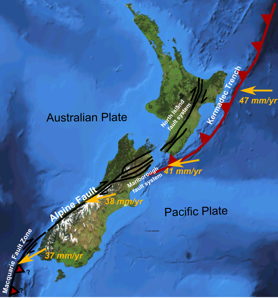
 Major active fault zones of New Zealand showing variation in displacement vector of Pacific Plate relative to Australian Plate along the boundary
The Marlborough Fault System is a set of four large dextral strike-slip faults and other related structures in the northern part of South Island, New Zealand, which transfer displacement between the mainly transform plate boundary of the Alpine fault and the mainly destructive boundary of the Kermadec Trench, and together form the boundary between the Australian and Pacific Plates.[1]
Contents
Geometry
The Marlborough Fault System consists of four main dominantly strike-slip fault strands, which together carry almost all of the displacement associated with the plate boundary. Other smaller faults form as splays of these main faults or accommodate deformation of the crust between them, such as the Newton and Hura Faults at the western end of the Hope Fault and the Jordan Thrust that formed the Seaward Kaikoura Range. The dextral strike-slip across this zone has also involved clockwise rotation of the intervening fault blocks of about 20° since the early Pliocene.[2]
Development
The Marlborough Fault System formed at about 5 Ma, during the early Pliocene, in response to a change in plate motions. The new plate vector was significantly oblique to the Alpine Fault, causing an increased amount of convergence. The set of strike-slip faults formed to accommodate this change by taking up most of the strike-slip component. [3]
Faults
There are four main fault strands, although many other smaller faults, of either strike-slip or thrust type are known.
Hope Fault
Main article: Hope FaultThe Hope Fault forms the southernmost part of the Marlborough Fault System. The estimated slip-rate during the Holocene is 20–25 mm/yr, just over half of the plate boundary displacement. At its northeastern end it links into the Jordan Thrust and most of the displacement is transferred onto that structure. It takes its name from the Hope River, which runs along one of the central fault segments.[1]
Clarence Fault
Main article: Clarence FaultThe Clarence Fault runs from close to the Alpine Fault to about 10 km west of Ward, where it appears to terminate abruptly. A Holocene slip-rate of 3.5–5.0 mm/yr is estimated for this fault. At the surface the displacement appears to be nearly pure horizontal, but continuous uplift of the neighbouring Inner Kaikoura Range over the same period, suggests that some of the dip-slip component thought to be present at depth on the fault zone is transferred onto thrust or reverse faults under the range.[4] An extra 10° of clockwise rotation has been recognised within the block that lies northeast of the tip of the Clarence fault.[2] It takes its name from the Clarence River, which follows the fault trace in the northeastern section of the fault.
Awatere Fault
Main article: Awatere FaultIt is formed of two main segments; the Molesworth section to the southwest and the Eastern section to the northeast. The estimated recent slip-rate for the Molesworth section is 4.4 mm/yr.[5] It takes its name from the Awatere River whose valley follows the fault trace along some of its length.
Wairau Fault
Main article: Wairau FaultThe Wairau Fault is sometimes regarded as a direct continuation of the Alpine Fault and may be referred to as the Alpine-Wairau Fault. It takes its name from the Wairau River, which follows the fault trace for most of its length. It has an estimated slip-rate of 3–5 mm/yr.[6]
Seismicity
All parts of the Marlborough Fault System are currently seismically active. Historical earthquakes (since European settlement) have occurred on both the Hope and Awatere Faults and on the smaller Poulter Fault. Studies of the geomorphology and the use of trenching across fault strands, has identified many earthquakes that occurred during the Holocene on many parts of the fault system.[1][4][5][6] The Hope Fault, which has the fastest slip rate is characterised by the shortest recurrence interval.
References
- ^ a b c Langridge, R.; Campbell J., Hill N., Pere V., Pope J., Pettinga J., Estrada B. & Berryman K. (2003). "Paleoseismology and slip rate of the Conway Segment of the Hope Fault at Greenburn Stream, South Island, New Zealand". Annals of Geophysics 46 (5). http://www.earth-prints.org/bitstream/2122/1007/1/1119_1140Langridge.pdf. Retrieved 27 June 2010.
- ^ a b Roberts, A.P. (1995). "Tectonic rotation about the termination of a major strike‐slip fault, Marlborough Fault System, New Zealand". Geophysical Research Letters 22 (3): 187–190. Bibcode 1995GeoRL..22..187R. doi:10.1029/94GL02582. http://www.agu.org/pubs/crossref/1995/94GL02582.shtml. Retrieved June 27, 2010.
- ^ Musgrave, R.J.. "Early to Middle Miocene Pacific-Australia plate boundary in New Zealand: an alternative transcurrent-fault system". In Hillis R.R. & Müller R.D.. Evolution and dynamics of the Australian plate. Geological Society of Australia Special Publications. 22. Geological Society of America. pp. 333–341. ISBN 9780813723723. http://books.google.co.uk/books?id=Ch_1JlLkKE0C&pg=PA333&lpg=PA333&dq=musgrave+plate+boundary+2003+new+zealand+alternative&source=bl&ots=hIDa14jdDJ&sig=9yvHjZxrfQzMpGUHGx0hS0xBct0&hl=en&ei=NCUvTM-fG6f20wTivLCZAw&sa=X&oi=book_result&ct=result&resnum=1&ved=0CBUQ6AEwAA#v=onepage&q=musgrave%20plate%20boundary%202003%20new%20zealand%20alternative&f=false. Retrieved 3 July 2010.
- ^ a b Nicol, A.; Van Dissen R. (2002). "Up-dip partitioning of displacement components on the oblique-slip Clarence Fault, New Zealand". Journal of Structural Geology 24 (9): 1521–1535. doi:10.1016/S0191-8141(01)00141-9. http://www.sciencedirect.com/science?_ob=ArticleURL&_udi=B6V9D-44HYFKT-1&_user=10&_coverDate=09%2F30%2F2002&_rdoc=1&_fmt=high&_orig=search&_sort=d&_docanchor=&view=c&_searchStrId=1383200950&_rerunOrigin=google&_acct=C000050221&_version=1&_urlVersion=0&_userid=10&md5=bebf097239f617fa380d92c27527c3d2.
- ^ a b Mason, D.P.M.; Little T.A. & Van Dissen R.J. (2006). "Rates of active faulting during late Quaternary fluvial terrace formation at Saxton River, Awatere fault, New Zealand". Geological Society of America Bulletin 118 (11-12): 1431–1446. doi:10.1130/B25961.1. http://bulletin.geoscienceworld.org/cgi/content/abstract/118/11-12/1431. Retrieved 27 June 2010.
- ^ a b Zachariasen, J.; Berryman K., Langridge R., Prentice C., Rymer M., Striling M. & Villamor P. (2006). "Timing of late Holocene surface rupture of the Wairau Fault, Marlborough, New Zealand". New Zealand Journal of Geology and Geophysics 49 (1): 159–174. http://www.royalsociety.org.nz/media/publications-journals-nzjg-2006-013-lo.pdf. Retrieved 2 July 2010.
Seismic faults of New Zealand North Island North Island Fault System Wairarapa Fault · Wellington Fault
South Island Marlborough Fault System Awatere Fault · Clarence Fault · Hope Fault · Wairau Fault
Canterbury Fault System Christchurch Fault · Greendale Fault · Port Hills Fault
Other Categories:- Seismic faults of New Zealand
Wikimedia Foundation. 2010.