- Mekor Chaim
-
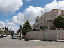 Mekor Chaim Street, Jerusalem
Mekor Chaim (also Makor Haim, Hebrew: מקור חיים, lit. Source of life) is a neighborhood in southwest Jerusalem, Israel.[1] It was named for Haim Cohen, a wealthy Jewish businessmen who donated large sums of money toward the purchase of land in Jerusalem before World War I.[2]
History
The funds donated to Hovevei Zion by Haim Cohen were transferred to the Jewish National Fund, which purchased 120 dunams of land on the southern fringes of Jerusalem. Mekor Chaim was established in 1926 by the religious Zionist Mizrahi movement.[2] It was planned as a village of 20 small farmsteads,[3] and was built along one main street which developed parallel to the railway line. Each family received a two-dunam plot for a house, garden and orchard. In the early days, the families had cow sheds and chicken coops. The building contractor, Mar Haim, was head of the first neighborhood committee. He arranged for the Hamekasher bus company to open a regular route between Mekor Chaim and the city center.[2] Initially, there was one central water tap in the south of the neighborhood. The committee purchased the water from the municipality and placed a watchman at the tap to count how many buckets each family drew. Later, raised water cisterns were built in the garden of each home. During the Arab riots of 1929, the residents took shelter in the synagogue, which was built like a fortress.
Located between the Arab villages of Malha and Beit Safafa, and far from other Jewish neighborhoods, Mekor Chaim was exposed to Arab sniping and endured a lengthy siege that began in December 1947. Convoys of supplies from Talpiot to Mekor Chaim were turned back by the British Army.[4] In the 1948 war, the Haganah was stationed there and it was the site of fierce battles.[1]
After the Six-Day War, the Talpiot industrial zone was developed, ending the neighborhood's isolation. In the mid-1980s, the Jerusalem city council established zoning laws to stop the encroachment of commerce and preserve the residential character of Mekor Chaim.[2]
Education
The Sudbury Democratic School is located in Mekor Chaim.[5]
References
- ^ a b "The Battle for Jerusalem in the War of Independence (1947–1948)". Jewish Virtual Library. 1996. http://www.jewishvirtuallibrary.org/jsource/History/battle47.html. Retrieved 19 March 2011.
- ^ a b c d "Jerusalem Neighborhoods: Mekor Haim". Municipality of Jerusalem. http://www.jerusalem.muni.il/jer_sys/picture/atarim/Toursite_form_atarEng.asp?site_id=2237&pic_cat=4&icon_cat=6&york_cat=9&type_id=197. Retrieved 19 March 2011.
- ^ "Rehavia & Makor Haim". Jewish Virtual Library. 1996. http://www.jewishvirtuallibrary.org/jsource/Society_&_Culture/geo/Rehavia.html. Retrieved 19 March 2011.
- ^ Steinberg, Jessica (17 April 2008). "Passover in Palestine: Memories of Seders in an Israel on the cusp of statehood". jewishjournal.com. http://www.jewishjournal.com/articles/article/passover_in_palestine_memories_of_seders_in_an_israel_on_the_cusp_of_stateh/. Retrieved 19 March 2011.
- ^ Cohen Yeshurun, Rachel. "Can a Democratic School Provide a Religious Education?". jdemschool.tripod.com. http://jdemschool.tripod.com/aricle12jewishedu.htm. Retrieved 19 March 2011.
Neighborhoods of Jerusalem Old City 
East Jerusalem American Colony • Al Bustan • Al-Issawiya • At-Tur • Bab a-Zahara • Beit Hanina • Jabel Mukaber • Ma'ale ha-Zeitim • Nachalat Shimon • Nof Zion • Ras al-Amud • Sheikh Jarrah • Shimon HaTzadik • Shuafat • Silwan • Sur Baher • Umm Tuba • Wadi al-JozHaredi neighborhoods Batei Munkatch • Batei Ungarin • Beit Yisrael • Ezrat Torah • Geula • Givat Shaul • Har Nof • Kerem Avraham • Kiryat Belz • Kiryat Mattersdorf • Kiryat Sanz • Kiryat Shomrei Emunim • Machanayim • Mea Shearim • Mekor Baruch • Nachalat Ya'akov • Ramat Shlomo • Ramot Polin • Sanhedria • Sanhedria Murhevet • Sha'arei Hesed • Shmuel HaNavi • Tel Arza • Unsdorf • Zikhron MosheCentral Neighborhoods Batei Nissan Bak • Beit David • Beit Ya'akov • Bukharan neighborhood • Even Yisrael • Ezrat Yisrael • Givat Ram • Katamon • Kiryat Shmuel • Kiryat Wolfson • Mahane Israel • Mahane Yehuda • Merhavia • Mishkenot Sha'ananim • Musrara • Nachalat Achim • Nachlaot • Nayot • Neve Sha'anan • Ohel Shlomo • Rehavia • Yemin MosheNorthern Neighborhoods French Hill • Givat HaMivtar • Ma'alot Dafna • Neve Yaakov • Pisgat Ze'ev • Ramat Eshkol • Ramot • Ramot PolinSouthern Neighborhoods Abu Tor • Baka • Beit Safafa • East Talpiot • The German Colony • Gilo • Givat HaMatos • Greek colony • Har Homa • Mekor Chaim • Ramat Rachel • TalpiotWestern Neighborhoods Bayit VeGan • Beit HaKerem • Givat Massuah • Givat Mordechai • Givat Oranim • Har Hotzvim • Ir Ganim • Katamonim • Kiryat HaYovel • Kiryat Menachem • Kiryat Moshe • Malha • Motza • Pat • Ramat Beit HaKerem • Ramat Denya • Ramat Sharett • Romema • Yefeh NofHistoric Neighborhoods See also: Ring Neighborhoods Coordinates: 31°45′14.55″N 35°12′45.2″E / 31.7540417°N 35.212556°E
Categories:- Neighbourhoods of Jerusalem


Wikimedia Foundation. 2010.