- Mercury Island
-
Mercury Island 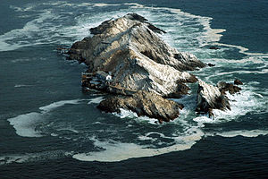
Mercury Island from the air. Note the building on the center left of this photograph for scale.
 Mercury IslandMercury Island (Namibia)
Geography Location Atlantic Ocean Coordinates 25°43′00″S 14°50′00″E / 25.7166667°S 14.8333333°ECoordinates: 25°43′00″S 14°50′00″E / 25.7166667°S 14.8333333°E Area 0.03 km2 (0.012 sq mi) Length 750 m (2,460 ft) Width 270 m (890 ft) Highest elevation 38 m (125 ft) Country NamibiaRegion Karas Region Constituency Lüderitz Constituency Demographics Population 2 (as of 2006) - not to be confused with the Mercury Islands of New Zealand
Mercury Island is a small rocky island off The Diamond Coast, Namibia. Despite its small size it is recognised by Bird Life and other global conservation groups as one of the Important Bird Areas (IBAs) for its important coastal seabird breeding.
Situation
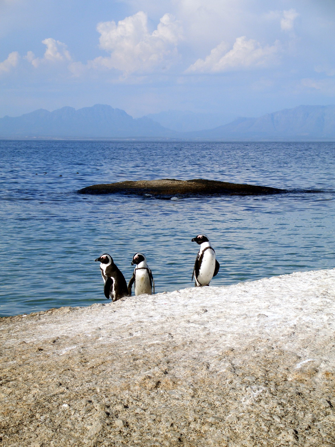
Mercury Island is situated in 800 metres offshore in Spencer Bay, 110 kilometres north of Lüderitz. The island is only 750 metres long (North-South) and about 270 metres wide, reaching a height of 38 metres above the sea. Steep, rocky, without vegetation, covered in a thick layer of bird guano, and riddled with a number of caves (one of which completely bisects the island), Mercury Island's name comes from the shaking which reverberates through the island during westerly wave action. Its nearest neighbour and like bird habitat is Ichaboe Island, about 65 kilometres to the south. With Ichaboe Island, Mercury is one of the two most important island seabird breeding sites along the Namibian coast. Consequently, it is permanently inhabited by a two-person bird research station, built on the remains of a bird guano mining dock[1] along the northeast side of the island.[2] The Island's 3 hectares are home to 16000 penguins, 1200 gannets and 5000 cormorants,[3] which range tens of kilometres out to sea, and return to the island to breed.[4]
Importance to wildlife
 Mercury Island and nearby islands support 96% of Namibia's endangered African Penguin population
Together with Ichaboe Island, Halifax Island and the Possession Islands, these islands support the entire Namibian breeding population of Cape Gannets Morus Capensis, 96% of the Namibian population of the endangered African Penguin Spheniscus Demersus, and nearly one quarter of the global breeding population of Crowned Cormorants Phalacrocorax coronatus.[5] Approximately 80% of the global population of the endangered Bank Cormorant Phalacrocorax neglectus breeds on Mercury Island and in the Ichaboe Islands.
There is a dwelling on the island, which is frequented by scientists and conservationists monitoring wildlife in the area.
References
- ^ Namibia: Forbidden Land. Infohub Travel.
- ^ P D MORANT. BENGUELA CURRENT LARGE MARINE ECOSYSTEM THEMATIC REPORT NO. 5: INTEGRATED OVERVIEW OF THE COASTAL ENVIRONMENT BETWEEN THE CONGO RIVER MOUTH AND CAPE AGULHAS. UNITED NATIONS DEVELOPMENT PROGRAMME/ENVIRONMENTEK, CSIR (South Africa). October 1999. pp. 78, 86.
- ^ Mercury Island, Namibia. Brady Gilchrist, Starship Millennium Voyage project, Thursday 15th February, 2001.
- ^ David Grémillet, Sue Lewis, Laurent Drapeau, Carl D. van Der Lingen, et al. Spatial match–mismatch in the Benguela upwelling zone: should we expect chlorophyll and sea-surface temperature to predict marine predator distributions? Journal of Applied Ecology 2008, 45, 610–621
- ^ "Walk on our coastline". Namibian Coast Conservation and Management Project (NACOMA). http://www.nacoma.org.na/Our_Coast/WalkOnOurCoastline.htm. Retrieved October 21, 2008.
Categories:- Lüderitz
- Geography of Karas Region
- Islands of Namibia
- Conservation in Namibia


Wikimedia Foundation. 2010.