- Minions, Cornwall
-
Coordinates: 50°30′51″N 4°27′17″W / 50.5142°N 4.4547°W
Minions Cornish: Menyon 
 Minions
Minions shown within CornwallOS grid reference SX261712 Parish Linkinhorne Unitary authority Cornwall Ceremonial county Cornwall Region South West Country England Sovereign state United Kingdom Post town LISKEARD Postcode district PL14 Dialling code 01579 Police Devon and Cornwall Fire Cornwall Ambulance South Western EU Parliament South West England UK Parliament South East Cornwall List of places: UK • England • Cornwall Minions (Cornish: Menyon) is a village in Cornwall, United Kingdom. It is situated on the eastern flank of Bodmin Moor northwest of Caradon Hill approximately four miles (6 km) north of Liskeard[1].
Minions is in the former Caradon administrative district and in the parish of Linkinhorne. At 300 metres (980 ft) it is said to be the highest village in Cornwall.
A stone circle known as the Hurlers is located on the west side of the village. Several other tumuli are also in the area, including Rillaton round barrow, where a Bronze Age gold beaker was discovered.
The Cheesewring, a distinctive rock formation, is a mile northwest.
Gallery
-

Street of cottages
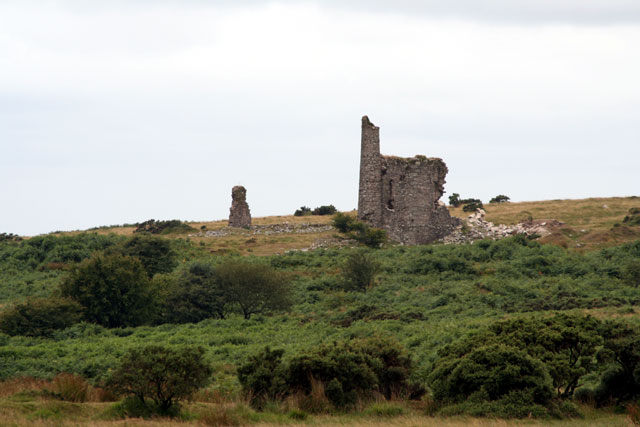
-

Engine house of a disused mine
-

Disused granite quarry on the moor
References
- ^ Ordnance Survey: Landranger map sheet 201 Plymouth & Launceston ISBN 9780319231463
Geography of Cornwall Cornwall Portal Unitary authorities Major settlements Bodmin • Bude • Callington • Camborne • Camelford • Falmouth • Fowey • Hayle • Helston • Launceston • Liskeard • Looe • Lostwithiel • Marazion • Newlyn • Newquay • Padstow • Par • Penryn • Penzance • Porthleven • Redruth • Saltash • St Austell • St Blazey • St Columb Major • St Ives • St Just-in-Penwith • St Mawes • Stratton • Torpoint • Truro • Wadebridge
See also: Civil parishes in CornwallRivers Topics History • Status debate • Flag • Culture • Places • People • The Duchy • Diocese • Politics • Hundreds/shires • Places of interest • full list...Categories:- Cornwall geography stubs
- Villages in Cornwall
- Bodmin Moor
-


Wikimedia Foundation. 2010.