National Register of Historic Places listings in Lake County, Minnesota
- National Register of Historic Places listings in Lake County, Minnesota
-
This is a list of sites on the National Register of Historic Places in Lake County, Minnesota. See National Register of Historic Places listings in Minnesota.
Current listings
|
Landmark name |
Image |
Date listed |
Location |
City or Town |
Summary |
| 1 |
Knife River |
|
| 2 |
Bridge No. 3589-Silver Creek Township |
 |
01998-06-29 June 29, 1998 |
U.S. Route 61 over the Stewart River
47°2′59″N 91°37′50″W / 47.04972°N 91.63056°W / 47.04972; -91.63056 (Bridge No. 3589--Silver Creek Township) |
Silver Creek Township |
|
| 3 |
Duluth and Iron Range Railroad Company Depot |
 |
01983-02-24 February 24, 1983 |
6th St. off South Ave.
47°1′9″N 91°40′12″W / 47.01917°N 91.67°W / 47.01917; -91.67 (Duluth and Iron Range Railroad Company Depot) |
Two Harbors |
|
| 4 |
John Dwan Office Building |
 |
01992-06-11 June 11, 1992 |
201 Waterfront Dr.
47°1′15″N 91°40′15″W / 47.02083°N 91.67083°W / 47.02083; -91.67083 (Dwan, John, Office Building) |
Two Harbors |
|
| 5 |
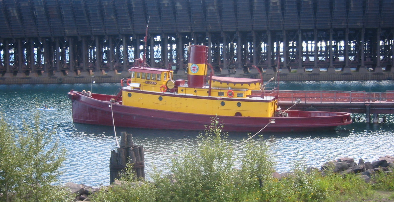
EDNA G (tugboat) |
 |
01975-06-05 June 5, 1975 |
Home port at the southern end of Poplar St. in Agate Bay
47°1′1″N 91°40′16″W / 47.01694°N 91.67111°W / 47.01694; -91.67111 (EDNA G (tugboat)) |
Two Harbors |
|
| 6 |
Gooseberry Falls State Park CCC/WPA/Rustic Style Historic Resources |
 |
01989-10-25 October 25, 1989 |
Off U.S. Route 61 northeast of Two Harbors
47°8′44″N 91°27′58″W / 47.14556°N 91.46611°W / 47.14556; -91.46611 (Gooseberry Falls State Park CCC/WPA/Rustic Style Historic Resources) |
Two Harbors |
|
| 7 |
HESPER Shipwreck Site |
 |
01994-04-14 April 14, 1994 |
Address Restricted |
Silver Bay |
|
| 8 |
Isabella Ranger Station |
|
02006-02-01 February 1, 2006 |
Address Restricted |
Isabella |
|
| 9 |
Lake County Courthouse and Sheriff's Residence |
 |
01983-02-24 February 24, 1983 |
601 3rd Ave.
47°1′20″N 91°40′16″W / 47.02222°N 91.67111°W / 47.02222; -91.67111 (Lake County Courthouse and Sheriff's Residence) |
Two Harbors |
|
| 10 |
Larsmont School |
 |
01992-06-18 June 18, 1992 |
County Highway 61
46°58′47″N 91°44′51″W / 46.97972°N 91.7475°W / 46.97972; -91.7475 (Larsmont School) |
Two Harbors |
|
| 11 |
MADEIRA (Schooner-Barge) Shipwreck |
 |
01992-07-23 July 23, 1992 |
Address Restricted |
Beaver Bay |
|
| 12 |
Edward and Lisa Mattson House and Fish House |
 |
01990-08-09 August 9, 1990 |
Off U.S. Route 61 at the Beaver Bay shore near Wieland Island
47°16′2″N 91°16′56″W / 47.26722°N 91.28222°W / 47.26722; -91.28222 (Mattson, Edward and Lisa, House and Fish House) |
East Beaver Bay |
|
| 13 |
Knife River |
Extra information |
| 14 |
Knife River |
|
| 15 |
SAMUEL P. ELY Shipwreck |
 |
01992-06-18 June 18, 1992 |
Address Restricted |
Two Harbors |
|
| 16 |
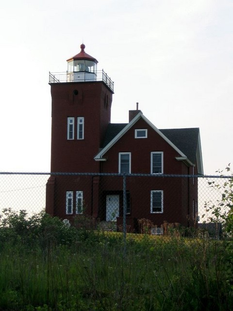
Split Rock Lighthouse |
 |
01969-06-23 June 23, 1969 |
About 20 miles northeast of Two Harbors on U.S. Route 61
47°12′1″N 91°22′3″W / 47.20028°N 91.3675°W / 47.20028; -91.3675 (Split Rock Lighthouse) |
Two Harbors |
|
| 17 |
Tettegouche Camp Historic District |
|
01989-01-17 January 17, 1989 |
Off County Highway 4
47°20′50″N 91°15′38″W / 47.34722°N 91.26056°W / 47.34722; -91.26056 (Tettegouche Camp Historic District) |
Silver Bay |
|
| 18 |
Two Harbors Carnegie Library |
 |
01986-07-31 July 31, 1986 |
4th Ave. and Waterfront Dr.
47°1′22″N 91°40′14″W / 47.02278°N 91.67056°W / 47.02278; -91.67056 (Two Harbors Carnegie Library) |
Two Harbors |
|
| 19 |
Two Harbors Light Station |
 |
01984-07-19 July 19, 1984 |
Agate and Burlington Bays
47°0′50″N 91°39′49″W / 47.01389°N 91.66361°W / 47.01389; -91.66361 (Two Harbors Light Station) |
Two Harbors |
|
Categories:
- Lake County, Minnesota
- National Register of Historic Places in Minnesota by county
- Buildings and structures in Lake County, Minnesota
Wikimedia Foundation.
2010.
Look at other dictionaries:
National Register of Historic Places listings in Ramsey County, Minnesota — Ramsey County This is a complete list of National Register of Historic Places listings in Ramsey County, Minnesota. There are 111 properties in the county listed on the National Register of Historic Places including three National Historic… … Wikipedia
National Register of Historic Places listings in Beltrami County, Minnesota — Location of Beltrami County in Minnesota This is a list of the National Register of Historic Places listings in Beltrami County, Minnesota. It is intended to be a complete list of the properties and districts on the National Register of Historic… … Wikipedia
National Register of Historic Places listings in Kandiyohi County, Minnesota — Location of Kandiyohi County in Minnesota This is a list of the National Register of Historic Places listings in Kandiyohi County, Minnesota. It is intended to be a complete list of the properties and districts on the National Register of… … Wikipedia
National Register of Historic Places listings in Koochiching County, Minnesota — Location of Koochiching County in Minnesota This is a list of the National Register of Historic Places listings in Koochiching County, Minnesota. It is intended to be a complete list of the properties and districts on the National Register of… … Wikipedia
National Register of Historic Places listings in Scott County, Minnesota — Location of Scott County in Minnesota This is a list of the National Register of Historic Places listings in Scott County, Minnesota. This is intended to be a complete list of the properties and districts on the National Register of Historic… … Wikipedia
National Register of Historic Places listings in Faribault County, Minnesota — Location of Faribault County in Minnesota This is a list of the National Register of Historic Places listings in Faribault County, Minnesota. It is intended to be a complete list of the properties and districts on the National Register of… … Wikipedia
National Register of Historic Places listings in Nobles County, Minnesota — Location of Nobles County in Minnesota This is a list of the National Register of Historic Places listings in Nobles County, Minnesota. It is intended to be a complete list of the properties and districts on the National Register of Historic… … Wikipedia
National Register of Historic Places listings in Pope County, Minnesota — Location of Pope County in Minnesota This is a list of the National Register of Historic Places listings in Pope County, Minnesota. It is intended to be a complete list of the properties and districts on the National Register of Historic Places… … Wikipedia
National Register of Historic Places listings in Aitkin County, Minnesota — Location of Aitkin County in Minnesota This is a list of the National Register of Historic Places listings in Aitkin County, Minnesota. It is intended to be a complete list of the properties and districts on the National Register of Historic… … Wikipedia
National Register of Historic Places listings in Lyon County, Minnesota — Location of Lyon County in Minnesota This is a list of the National Register of Historic Places listings in Lyon County, Minnesota. It is intended to be a complete list of the properties and districts on the National Register of Historic Places… … Wikipedia