National Register of Historic Places listings in Stephenson County, Illinois
- National Register of Historic Places listings in Stephenson County, Illinois
-
See also: List of Registered Historic Places in Illinois
Contents: List of Registered Historic Places in Stephenson County, Illinois, USA:
-
- This National Park Service list is complete through NPS recent listings posted November 10, 2011.[1]
|
Landmark name |
Image |
Date listed |
Location |
City or Town |
Summary |
| 1 |
John H. Addams Homestead |
 |
01979-04-17 April 17, 1979 |
425 N. Mill St.
42°23′26″N 89°38′16″W / 42.39056°N 89.63778°W / 42.39056; -89.63778 (Addams, John H., Homestead) |
Cedarville |
|
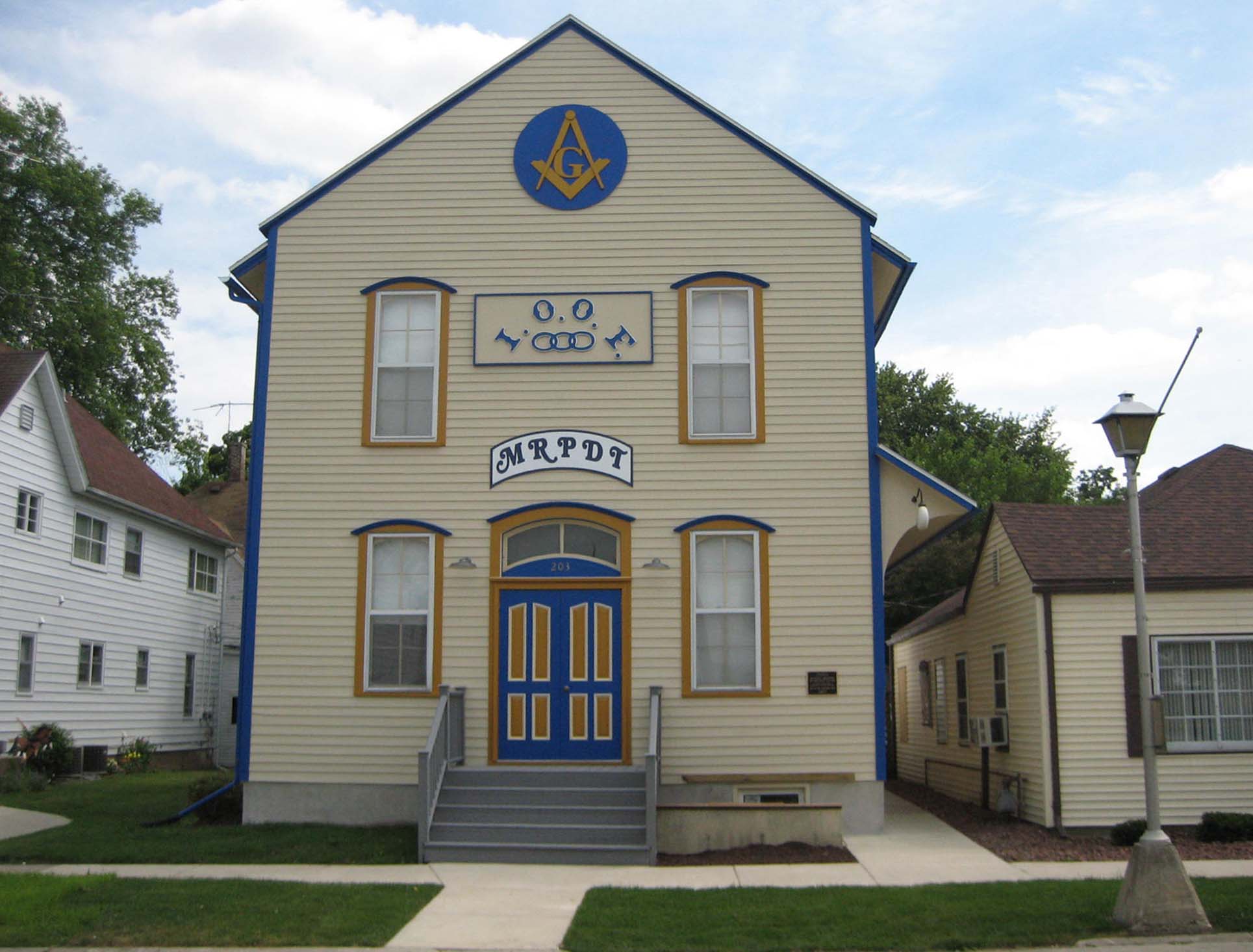
| 2 |
AF and AM Lodge 687, Orangeville |
 |
02003-05-09 May 9, 2003 |
203 W. High St.
42°28′6″N 89°38′44″W / 42.46833°N 89.64556°W / 42.46833; -89.64556 (AF and AM Lodge 687, Orangeville) |
Orangeville |
|
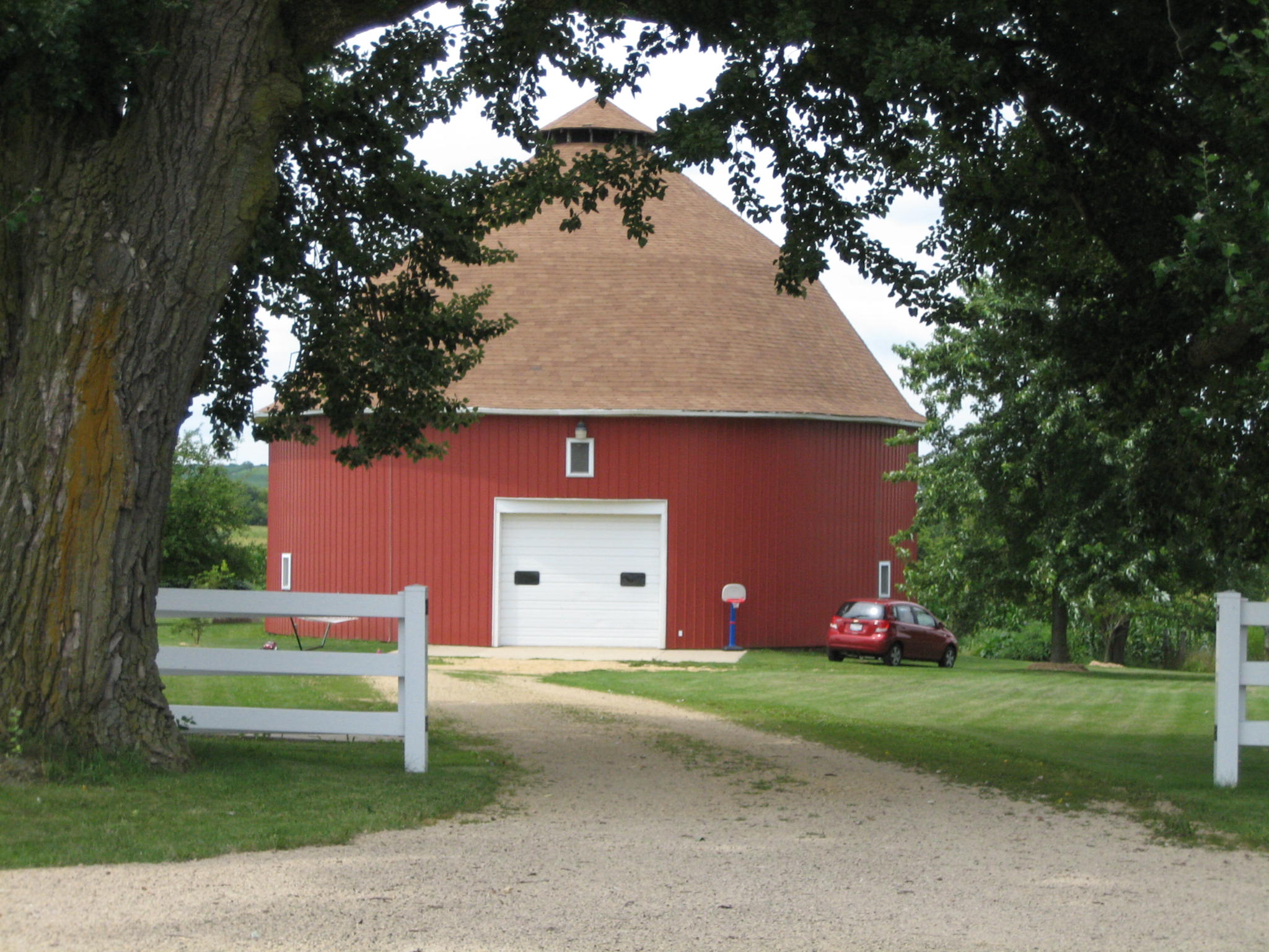
| 3 |
James Bruce Round Barn |
 |
01984-02-23 February 23, 1984 |
S of Freeport
42°15′7″N 89°38′57″W / 42.25194°N 89.64917°W / 42.25194; -89.64917 (Bruce, James, Round Barn) |
Freeport |
|
| 4 |
Central House |
 |
01999-05-20 May 20, 1999 |
210 W. High St.
42°28′9″N 89°38′47″W / 42.46917°N 89.64639°W / 42.46917; -89.64639 (Central House) |
Orangeville |
|
| 5 |
Charles Fehr Round Barn |
 |
01984-02-23 February 23, 1984 |
NE of Orangeville
42°29′46″N 89°31′20″W / 42.49611°N 89.52222°W / 42.49611; -89.52222 (Fehr, Charles, Round Barn) |
Orangeville |
|
| 6 |
Gerald Harbach Round Barn |
 |
01984-02-23 February 23, 1984 |
US 20
42°19′40″N 89°44′4″W / 42.32778°N 89.73444°W / 42.32778; -89.73444 (Harbach, Gerald, Round Barn) |
Eleroy |
|
| 7 |
Chris Jensen Round Barn |
|
01984-02-23 February 23, 1984 |
11723 W. Galena Rd.
42°23′30″N 89°50′6″W / 42.39167°N 89.835°W / 42.39167; -89.835 (Jensen, Chris, Round Barn) |
Lena |
|
| 8 |
Kellogg's Grove |
 |
01978-06-23 June 23, 1978 |
SE of Kent
42°17′46″N 89°53′13″W / 42.29611°N 89.88694°W / 42.29611; -89.88694 (Kellogg's Grove) |
Kent |
|
| 9 |
Lena Water Tower |
 |
01997-02-20 February 20, 1997 |
201 Vernon St.
42°22′49″N 89°49′41″W / 42.38028°N 89.82806°W / 42.38028; -89.82806 (Lena Water Tower) |
Lena |
|
| 10 |
Dennis Otte Round Barn |
 |
01984-02-23 February 23, 1984 |
E of Eleroy
42°20′1″N 89°44′16″W / 42.33361°N 89.73778°W / 42.33361; -89.73778 (Otte, Dennis, Round Barn) |
Eleroy |
|
| 11 |
People's State Bank |
 |
02004-08-20 August 20, 2004 |
300 W. High St.
42°28′15″N 89°38′49″W / 42.47083°N 89.64694°W / 42.47083; -89.64694 (People's State Bank) |
Orangeville |
|
| 12 |
William Ritzman House |
 |
02000-10-27 October 27, 2000 |
10715 IL 26 N
42°27′33″N 89°38′30″W / 42.45917°N 89.64167°W / 42.45917; -89.64167 (Ritzman, William, House) |
Orangeville |
|
| 13 |
Soldiers' Monument |
 |
01998-06-01 June 1, 1998 |
15 N. Galena Ave.
42°17′52″N 89°37′19″W / 42.29778°N 89.62194°W / 42.29778; -89.62194 (Soldiers' Monument) |
Freeport |
|
| 14 |
Stephenson County Courthouse |
|
01974-01-17 January 17, 1974 |
Courthouse Sq.
42°17′53″N 89°37′19″W / 42.29806°N 89.62194°W / 42.29806; -89.62194 (Stephenson County Courthouse) |
Freeport |
Apparently demolished, but still listed on the National Register in 2009 |
| 15 |
Oscar Taylor House |
 |
01984-05-11 May 11, 1984 |
1440 S. Carroll Ave.
42°17′4″N 89°36′54″W / 42.28444°N 89.615°W / 42.28444; -89.615 (Taylor, Oscar, House) |
Freeport |
|
| 16 |
Union House |
 |
02000-05-11 May 11, 2000 |
207 W. High St.
42°28′6″N 89°38′45″W / 42.46833°N 89.64583°W / 42.46833; -89.64583 (Union House) |
Orangeville |
|
See also
References
Categories:
- Stephenson County, Illinois
- National Register of Historic Places in Illinois by county
- National Register of Historic Places in Stephenson County, Illinois
Wikimedia Foundation.
2010.
Look at other dictionaries:
National Register of Historic Places listings in Madison County, Illinois — See also: National Register of Historic Places listings in Illinois Contents: National Register of Historic Places listings in Madison County, Illinois, USA: This National Park Service list is complete through NPS recent listings posted November… … Wikipedia
National Register of Historic Places listings in Cook County, Illinois — For places listed on the National Register in Chicago, see National Register of Historic Places listings in Chicago. Map of all coordinates from Google Map of all coordinates from Bing … Wikipedia
National Register of Historic Places listings in Clarke County, Mississippi — Location of Clarke County in Mississippi This is a list of the National Register of Historic Places listings in Clarke County, Mississippi. This is intended to be a complete list of the properties and districts on the National Register of… … Wikipedia
National Register of Historic Places listings in Madison County, Kentucky — Location of Madison County in Kentucky This is a list of the National Register of Historic Places listings in Madison County, Kentucky. This is intended to be a complete list of the properties and districts on the National Register of Historic… … Wikipedia
National Register of Historic Places listings in Searcy County, Arkansas — Location of Searcy County in Arkansas This is a list of the National Register of Historic Places listings in Searcy County, Arkansas. This is intended to be a complete list of the properties and districts on the National Register of Historic… … Wikipedia
National Register of Historic Places listings in Lee County, Iowa — Location of Lee County in Iowa This is a list of the National Register of Historic Places listings in Lee County, Iowa. This is intended to be a complete list of the properties and districts on the National Register of Historic Places in Lee… … Wikipedia
National Register of Historic Places listings in Boone County, Arkansas — Location of Boone County in Arkansas This is a list of the National Register of Historic Places listings in Boone County, Arkansas. This is intended to be a complete list of the properties and districts on the National Register of Historic Places … Wikipedia
National Register of Historic Places listings in Boone County, Kentucky — Location of Boone County in Kentucky This is a list of the National Register of Historic Places listings in Boone County, Kentucky. This is intended to be a complete list of the properties and districts on the National Register of Historic Places … Wikipedia
National Register of Historic Places listings in Illinois — Map of all coordinates from Google Map of all coordinates from Bing … Wikipedia
National Register of Historic Places listings in Frederick County, Virginia — Map of all coordinates from Google Map of all coordinates from Bing … Wikipedia
 Category:National Register of Historic Places •
  Portal:National Register of Historic PlacesCategories: