- North Foreland
-
Coordinates: 51°22′29″N 1°26′42″E / 51.37472°N 1.445°E
 North Foreland is the eastern extremity of the Isle of Thanet
 The North Foreland lighthouse is visible on the right of the photo of Kingsgate Castle.
North Foreland [1] is a chalk headland on the Kent coast of southeast England.
North Foreland forms the eastern end of the Isle of Thanet. It presents a bold cliff to the sea, and commands views over the southern North Sea.
Contents
Lighthouse
The necessity for a lighthouse at this place must have become apparent when the Goodwin Sands became dangerous and when it was found that in directing their course so as to keep clear of this land which extends so far into the sea ships were extremely liable to strike on the sands at night before they were aware. There was probably some sort of a beacon at an earlier period but the first distinct intimation concerning a lighthouse on the North Foreland is in the year 1636 when Charles I by letters-patent granted to Sir John Meldrum licence to continue and renew the lighthouses erected on the North and South Forelands.[2]
It seems that the lighthouse erected by Sir John consisted merely of a house built with timber lath and plaster on the top of which a light was kept in a large glass lantern for the purpose of directing ships in their course. This house was burnt down by accident in the year 1683 after which for some years use was made of a sort of beacon on which a light was hoisted. But near the end of the same century a strong octagonal structure of flint was erected on the top of which was an iron grate quite open to the air in which a good fire of coals was kept blazing at night.[2]
 Illustration from The Penny Magazine
About the year 1732 the top of this lighthouse was covered with a sort of lantern with large sash windows and the fire was kept bright by bellows with which the attendants blew throughout the night. This contrivance is said to have been for the purpose of saving coals but it would seem more probable that it was in order to preserve the fire from being extinguished by rain. However the plan did not work well and great injury resulted to navigation as many vessels were lost on the sands from not seeing the light and so little was it visible at sea that mariners asserted that they had often in hazy weather seen the Foreland before they could discover the light. They added that before the lantern was placed there and when the fire was kept in the open air the wind kept the fire in a constant blaze which was seen in the air far above the lighthouse. Complaints of this sort were so loud and frequent that the governors of Greenwich Hospital to whom the lighthouse belonged sent Sir John Thomson to examine and make arrangements on the subject. He ordered the lantern to be taken away and things to be restored to nearly their former state the light to continue burning all the night until daylight.[2]
Towards the end of the 18th century the North Foreland Lighthouse underwent some considerable alterations and repairs. Two stories of brick were built on the original structure which raised it to the height of 100 feet including the room at the top in which the lights were kept. To prevent accidents from fire it was coated with copper as was also the gallery around it. This gallery used to be much frequented by the visitors to Margate on account of the extensive views. [2]
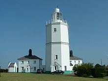 The lighthouse in 2005
Currently the North Foreland lighthouse is automated and unstaffed.
War
Two naval battles of the Anglo-Dutch Wars are called the Battle of the North Foreland after the cape:
- The Battle of the Gabbard, June 2 to June 3, 1653, in the First Anglo-Dutch War.
- The St. James's Day Battle, July 25 to July 26, 1666, in the Second Anglo-Dutch War.
References
External links
Categories:- Headlands of England
- Thanet
- Geography of Kent


Wikimedia Foundation. 2010.